Visitor info
All the practical information you need to know about Wombeyan Karst Conservation Reserve.
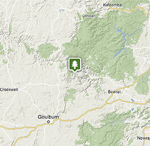
Getting there and parking
Get driving directions
You can only access Wombeyan Karst Conservation Reserve via Taralga and Wombeyan Caves Road. To get there:
From Sydney via Goulburn (3hr drive):
- Take the South Western Motorway to Goulburn
- From Goulburn, follow Tablelands Way through Taralga
- Take the Wombeyan Caves Road turnoff and drive for 23km (sealed and unsealed road).
From Sydney via Oberon (4hr drive):
- Take the M4 and Great Western Highway towards Lithgow
- Turn left onto Jenolan Caves Road, then after 23km turn right onto Duckmaloi Road
- From Oberon, follow Tablelands Way
- Take the Wombeyan Caves Road turnoff and drive for 23km (sealed and unsealed road).
From Canberra (2.5hr drive):
- Take the Federal Highway to Goulburn, then take Goulburn-Taralga-Oberon Road towards Taralga for about 45km
- Continue through Taralga for 10km until you reach the Wombeyan Caves turnoff
- Turn right onto Wombeyan Caves Road and drive for 23km (sealed and unsealed road).
From Wollongong (3hr drive):
- Take the Princes Highway towards Sydney
- Turn off at the Picton Road exit and follow for around 27km, then take the Hume Highway towards Goulburn
- From Goulburn, follow Tablelands Way through Taralga
- Take the Wombeyan Caves Road turnoff and drive for 23km (sealed and unsealed road).
Wombeyan Caves Road access via Mittagong is closed until further notice.
Refuel your vehicle on the way, as there is no petrol station at Wombeyan Karst Conservation Reserve.
Park entry points
- Wombeyan Caves East access See on map
- Wombeyan Caves West access See on map
Parking
- Accessible parking at Kui Kiosk See on map
- Wombeyan picnic area See on map
Road quality
- Mixture of sealed and unsealed roads
Vehicle access
- 2WD vehicles (no long vehicle access)
By bike
Check out the Bicycle information for NSW website for more information.
By public transport
For information about public transport options, visit the NSW country transport info website
Best times to visit
There are lots of great things waiting for you in Wombeyan Karst Conservation Reserve. Here are some of the highlights.
Autumn
Visit now and you'll see the gorgeous changing colours of the trees. The warm days and cool nights make this an ideaI time for camping.
Spring
While the caves can be visited all year round, a trip to Wombeyan in spring is well timed to catch wildflowers in full bloom.
Summer
A great time for a weekend camping trip - pitch your tent, enjoy breakfast cooked on the barbecue and the coolness of the caves on a guided tour.
Winter
Take advantage of the cooler weather and book a weekend getaway at Wombeyan Caves cabins.
Weather, temperature and rainfall
Summer temperature
Average
13°C and 26°C
Highest recorded
38.8°C
Winter temperature
Average
1°C and 11°C
Lowest recorded
-9.6°C
Rainfall
Wettest month
June
Driest month
April
The area’s highest recorded rainfall in one day
174.2mm
Facilities
Amenities
Toilets
Showers
Picnic tables
Barbecue facilities
Drinking water
Public phone Show more
Electric power
Maps and downloads
Prohibited
Drones
Flying a drone for recreational purposes is prohibited in this area. Drones may affect public enjoyment, safety and privacy, interfere with park operations, or pose a threat to wildlife. See the Drones in Parks policy.
This area may be a declared Drone Exclusion Zone, or may be subject to Civil Aviation Safety Authority (CASA) rules for flying near airports, aerodromes and helicopter landing sites. See CASA's Drone Flyer Rules.
Commercial filming and photography
Commercial filming or photography is prohibited without prior consent. You must apply for permission and contact the local office.
Gathering firewood
Firewood may not be collected from the park, so you'll need to bring your own supply.
Pets
Pets and domestic animals (other than certified assistance animals) are not permitted. Find out which regional parks allow dog walking and see the pets in parks policy for more information.
Smoking
NSW national parks are no smoking areas.
Contact
- in the Country NSW region
Wombeyan Karst Conservation Reserve is always open but may have to close at times due to poor weather or fire danger.
-
-
Wombeyan Caves office
02 4843 5976
Contact hours: 9am to 4.30pm daily. Closed Christmas Day. - 41 Victoria Arch Drive, Wombeyan Caves NSW 2580
-
Email: wombeyan.caves@environment.nsw.gov.au
-
Wombeyan Caves office
-
-
Oberon office
02 6336 6200
Contact hours: Monday to Friday, 9am to 4.30pm. - 38 Ross Street, Oberon NSW 2787
-
Email: npws.kanangra@environment.nsw.gov.au
-
Oberon office
Nearby towns
Taralga (26 km)
Many of Taralga's existing buildings date from the 1860s to the 1890s, and most of them consist of stone from local volcanic supplies. This has resulted in an architectural style unique to Taralga that is somewhere between Georgian and Victorian, giving the town a unique and picturesque aesthetic.
Crookwell (64 km)
Situated high on the Great Dividing Range more than 900 m above sea level, the area experiences four distinct seasons and is ideal for growing disease-free seed potatoes, making it a key supply area to Australia's potato-growing regions. Every March, the region celebrates the industry with the Crookwell Potato Festival.
Goulburn (72 km)
Named after Henry Goulburn - the British Secretary of State for the Colonies, Goulburn developed into a major centre for wool, and in 1863, it became Australia's first inland city. Today, the town is a rich hub of history, discovery and natural beauty.