Mountain Brush circuit
Tapin Tops National Park
What's nearby
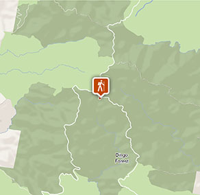
Nearby walking tracks
-
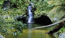
Potoroo Falls walk
Take a walk along Potoroo Falls walk which leads from the picnic area through rainforest to the beautiful Potoroo Falls, with its tranquil swimming hole.
Nearby things to do
-
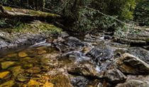
Potoroo Falls picnic area
Potoroo Falls picnic area is well-equipped with sheltered tables, wood barbecues and toilets. It’s a great place to enjoy a bite after you’ve walked to Potoroo Falls and had a splash in the swimming hole.
-
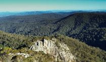
Rowleys Rock lookout
From Rowleys Rock lookout in Tapin Tops National Park, you can stand over 1000m above sea level and enjoy astonishing scenic views out over the park, Taree and beyond.
Nearby camping and accommodation
-
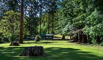
Dingo Tops campground
Dingo Tops campground is a great base to explore Tapin Tops National Park, with easy access to the park’s waterfalls and creeks and birdwatching opportunities.
Nearby parks
-
Tapin Tops National Park
A few hours drive north of Sydney, Tapin Tops National Park lies on a spectacular section of the Great Eastern Escarpment, high up in the mountains just northwest of Wingham.
Google Street View Trekker
Using Google Street View Trekker, we've captured imagery across a range of NSW national parks and attractions. Get a bird's eye view of these incredible landscapes before setting off on your own adventure.

Park info
- in Tapin Tops National Park in the North Coast region
Tapin Tops National Park is always open but may have to close at times due to poor weather or fire danger.