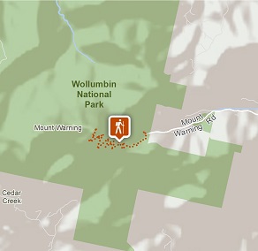
Wollumbin (Mount Warning) summit track
Wollumbin National Park
Visitor info
All the practical information you need to know about Wollumbin (Mount Warning) summit track.
Track grading
Features of this track
Distance
8.8km return
Time
5 - 6hrs
Quality of markings
Sign posted
Experience required
Some bushwalking experience recommended
Gradient
Very steep and difficult
Steps
Many steps
Quality of path
Formed track, some obstacles
Getting there and parking
Wollumbin National Park is located 12km south-west of Murwillumbah, off Kyogle Road.
From Murwillumbah:
- Take the Kyogle Rd towards Uki
- Around 10km from Murwillumbah, before you reach Uki, turn right into Mt Warning Road
- Continue 3.5km to the end of Mt Warning Rd, where you’ll reach Breakfast Creek carpark in the national park
Road quality
- Mount Warning Road is subject to rapidly rising floodwaters, even during localised storms.
- Sealed roads
Parking
- Limited parking is available at Breakfast Creek carpark. Not suitable for longer vehicles including coaches, caravans, and camper trailers.
- This is a high-risk area for theft, please don’t leave valuables in your car.
- Please make sure you don’t obstruct the emergency vehicle parking zone.
Facilities
- Toilet facilities are located at Breakfast Creek carpark.
- There are no toilets or rubbish facilities on the summit track. Please bag and carry out all waste, including toilet waste, to protect park environments and animals.
Maps and downloads
Accessibility
Not wheelchair-accessible.
Prohibited
Adventure activities including rock climbing and abseiling are prohibited in Wollumbin National Park.
Camp fires and solid fuel burners
Camping
Camping is not permitted in Wollumbin National Park. Camping and accommodation is available near the park on Mt Warning Road, and in Murwillumbah or Uki.
Generators
Pets
Pets and domestic animals (other than certified assistance animals) are not permitted. Find out which regional parks allow dog walking and see the pets in parks policy for more information.
Smoking
NSW national parks are no smoking areas.
Operated by
- Murwillumbah office
- npws.tweedbyron@environment.nsw.gov.au
Park info
- in Wollumbin National Park in the North Coast region
Wollumbin National Park is open, but may have to close at times due to perceived risk. The gate on Mount Warning Road entrance may also be closed from 5pm in winter and 6pm in summer (during daylight savings) and will reopen at 7am the following morning.