Overview
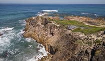
Experience 27km of coastal hiking over 2 or 3 days along Tomaree Coastal Walk, in Port Stephens. Start on a high at Tomaree Head Summit, learn about Worimi culture, and stay at one of the holiday parks or accommodation options.
- Where
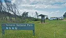
- Tomaree National Park in North Coast
- Accessibility
- No wheelchair access
- Distance
- 27km one-way
- Time suggested
- 2 - 3 days
- Grade
- Grade 4
- Trip Intention Form
-
It's a good idea to let someone know where you're going. Fill in a trip intention form to send important details about your trip to your emergency contact.
- What to
bring - Drinking water, hat, sunscreen, sturdy shoes, clothes for all weather conditions, mobile phone, first aid kit, dry bag, insect repellent, raincoat, snacks, tent, torch, towels
You can choose to tackle the 27 km Tomaree Coastal Walk over 2 or 3 days. We've included the 2 day itinerary below. If you're walking it over 3 days, you would just climb to Tomaree Head Summit and back on day 1 and start from Shoal Bay on day 2.
Day 1: Tomaree Head Summit to One Mile
Distance: 18 km
Time suggested: 7 to 8 hours
Toilets at: Shoal Bay, Fingal Bay, Barry Park, One Mile Beach
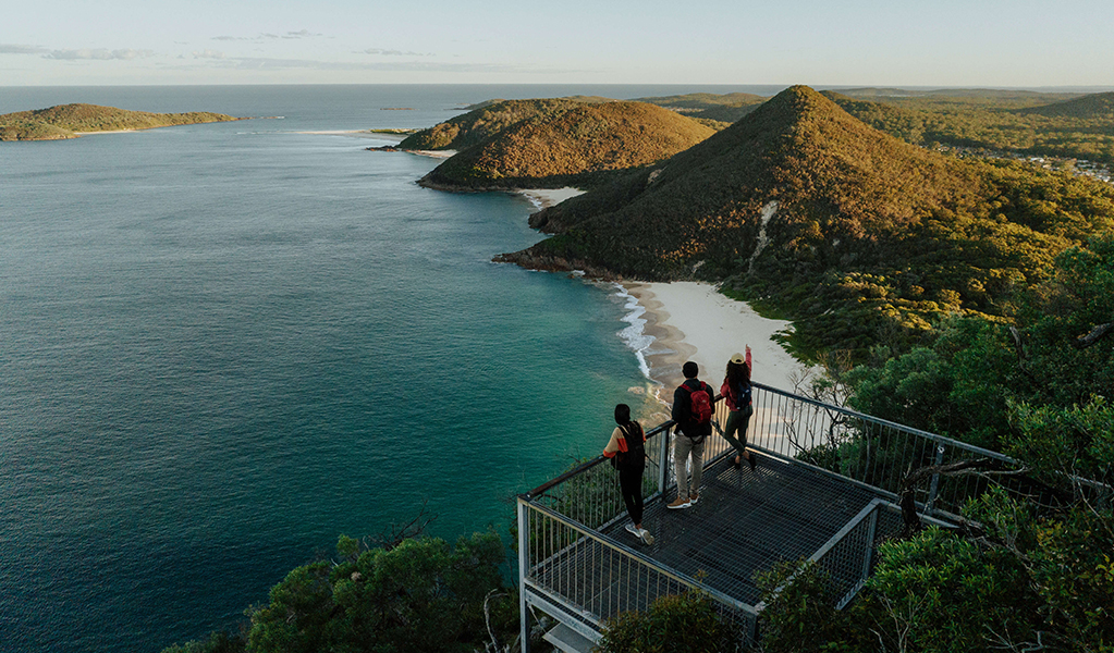
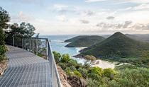
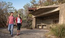
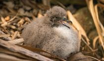
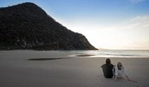
Day 1 is a big one, so rise early and make your way through Shoal Bay to the base of Tomaree Head Summit if you want to catch a spectacular sunrise from the highest point around. It’s a 2 km return walk to the summit and back, but well worth it. Check out the World War II gun emplacements and the Gould's Petrel augmented reality experience while you're up there.
After returning to the base, follow the trackhead signage featuring the iconic totem of a white-bellied sea eagle and begin the journey south across the sandy shores of Zenith Beach.
You'll traverse around the back of Quarry Hill where you might spot the resident echidnas on the hunt for ants. Listen out for wattlebirds and rare black glossy cockatoos in forests here.
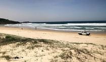
Fingal Bay is where you'll re-emerge, just in time for lunch and a swim if the weather is nice. We recommend swimming here if conditions are safe as it’s one of the few beaches with a lifeguard patrol.
Once you've had a well-deserved rest it's time to move on towards Barry Park which offers a spectacular lookout for whale watching as well as toilets and drinking water. The next section is the most remote part of the walk and this is your last chance to use any facilities until you reach One Mile Beach.
If the day is getting hot you'll be grateful for the cool shade of the forests soon. See if you can identify the melaleuca trees in the swampy areas, or the red bloodwoods and twisted limbs of smooth-barked apple forests on the hillsides. Every now and then you'll pass through a clump of striking gymea lilies, identified by the red spike of a single flower towering metres above you in the winter months.
If you happen to be walking in the cooler months, keep your eyes open for migrating humpback whales between May and November, as well as dolphins and sea eagles.
Near the end of your day, you can choose to take a short 200 metre side track down to a bay at Big Rocky, named for the dramatic volcanic red rocks that appear to have been violently pushed right up out of the earth. If you happen to arrive at low tide, you’ll be delighted by the wonders of the rockpools. It’s a great spot for a picnic and popular with those who enjoy fishing.
Once you reach the shores of Samurai Beach, you'll know that day 1 is almost done. Please note that Samurai Beach is clothing optional and also permits 4WDing on the sand. Climb up Middle Rock and follow the track away from the beach to end the day with a relaxing overnight stay at one of the holiday parks or accommodation options at One Mile.
Although there are no dinner options at One Mile you can order takeaway food to be delivered while you put your feet up and enjoy a well-earned rest. Or you might opt to take a short drive by bus, taxi, or car to one the many restaurants at Nelson Bay, Shoal Bay, or Anna Bay.
Day 2: One Mile to Birubi Point
Distance: 9 km
Time suggested: 3.5 to 4.5 hours
Toilets at: One Mile Beach, Boat Harbour, Fishermans Bay, Birubi Point
Today's hike is just 9 km so you might start the day with a visit to Port Stephens Koala Sanctuary or a swim at the south end of One Mile Beach where the surf lifesaving club is located.
You’ll enjoy salty air and sand dunes for miles as you follow the sea eagle totem on wayfinding signage along the coastline.
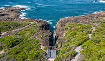
Take the winding sandstone track up the steps from One Mile Beach and into the eucalyptus forest. The walk guides you out across exposed coastal heathland populated with wrens and wattlebirds before you reach Slot canyon lookout which is sure to impress. Be sure to look for eagles and dolphins from this point, as well as migrating humpback whales between May and November.
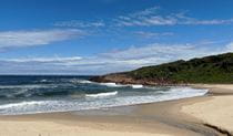
Continue along the coastal rock platforms and enjoy the especially pretty section tracing rocky bays and beaches just before you reach the sheltered coastal village of Boat Harbour. This is a good spot to take a break, refill your drinking water, and use the facilities.
The next section traverses Kingsley Beach followed by the smaller, more secluded Little Kingsley Beach. Climb up the sandstone path into a thick, windswept forest of tea tree and wattles and you’ll soon be delighted to find a surprise bridge tucked away in a small ferny gully among the twisted red and pink branches smooth barked apple or angophora trees.
Fishermans Bay is the next coastal village where you have a chance to refill your drinking water and use the facilities. From this point you can spot the unmistakable golden hills of Stockton Sand Dunes in Worimi Conservation Lands to the south. Continue along the coastal rock platforms keeping an eye out for the wayfinding signage and the tiny bridges that guide you to yet another impressive lookout. Perched on the edge of the rocks over the ocean is Iris Moore lookout and picnic area, where you might get a chance to watch some rock climbers and abseilers on the cliffs opposite.
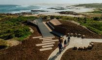
Your final wonder is the beautiful cultural artwork at Birubi Point Aboriginal Place, the ‘place of the Southern Cross’. Listen to the audio recording of Worimi artist, Gerard Black discussing the meaning of his artwork, ‘Matjarr nguka biinba’, as you learn the stories of this special place.
From here, it’s just a short stroll over to your final destination, Birubi Point where you can marvel at the sight of the largest coastal sand dune in the southern hemisphere. Reward yourself with a well-deserved swim at the patrolled beach, use the toilet facilities, and enjoy lunch. Congratulations, your 27 km adventure is complete.
Catch a bus or taxi back to your vehicle if you haven’t arranged a car shuffle from this location.
For those wanting to make the most of the afternoon, why not explore Worimi Conservation Lands further? You can try sandboarding, 4WD tours, camel rides, and more.
You can also choose to stay another night at one of the holiday parks or accomodation options in the area.
Along the way:

Local alerts
For the latest updates on fires, closures and other alerts in this area, see https://www.nationalparks.nsw.gov.au/things-to-do/walking-tracks/tomaree-coastal-walk-app/local-alerts
General enquiries
- National Parks Contact Centre
- 7am to 7pm daily
- 1300 072 757 (13000 PARKS) for the cost of a local call within Australia excluding mobiles
- parks.info@environment.nsw.gov.au
Park info
- in Tomaree National Park in the North Coast region
Tomaree National Park is always open but may have to close at times due to poor weather or fire danger.
Visitor info
All the practical information you need to know about Tomaree Coastal Walk.
Track grading
Features of this track
Distance
27km one-way
Time
2 - 3 days
Quality of markings
Clearly sign posted
Experience required
Some bushwalking experience recommended
Gradient
Short steep hills
Steps
Many steps
Quality of path
Formed track, some obstacles
Getting there and parking
The nearest town to the start point is Shoal Bay which is about 3 hours drive from Sydney and about 1 hour drive from Newcastle.
You’ll be starting the walk at Tomaree Head Summit near Shoal Bay. A combination of paid and free all-day parking is available along Shoal Bay Road, and at Zenith Beach upper and lower car parks. Refer to car park and road signage. Arrive early because this area is busy on weekends and in summer.
.From Nelson Bay:
- Follow Shoal Bay Road to the upper or lower Zenith Beach car park
Road quality
- Sealed roads
Vehicle access
- 2WD vehicles
Weather restrictions
- All weather
Parking
Parking is available at the upper or lower Zenith Beach car park.
On busy days you may need to find a parking spot on Shoal Bay Road.
By public transport
You can catch a bus or a local taxi from your accommodation to the base of Tomaree Head Summit.
Port Stephens Coaches run buses to Shoal Bay and Anna Bay. Route 130 stops at many locations along this walk including Shoal Bay, Nelson Bay, Fingal Bay, One Mile, Boat Harbour, Birubi Point and Anna Bay.
Visit the Transport for NSW website for trip planning.
Facilities
Toilets
Public toilets are available along this walk at: Fingal Bay Beach, One Mile Beach, Boat Harbour, Fishermans Bay, Robinson Reserve, and Birubi Point.
- Flush toilets
Showers
Beach shower facilities are available at Fingal Bay surf life saving club, One Mile Beach behind the surf life saving club, and Birubi Point surf life saving club.
- Cold showers
Picnic tables
Picnic tables are located at: Robinson Reserve near Birubi Point, Iris Moore lookout and picnic area, Fishermans Bay, Boat Harbour, One Mile Beach, and Fingal Bay Beach.
Cafe/kiosk
Cafés are located along the way at: Fingal Bay Beach, One Mile Beach, and Birubi Point (seasonal hours).
Carpark
Parking is available at the upper and lower car parks at Zenith Beach, behind Fingal Bay surf life saving club, behind One Mile Beach surf life saving club, Robinson Reserve at Anna Bay, and at Birubi Point surf life saving club.
Drinking water
Drinking water is available from amenities blocks along the way at: Fingal Bay, Barry Park, One Mile Beach, Boat Harbour, Fishermans Bay, and Birubi Point.
Maps and downloads
Accessibility
Disability access level - no wheelchair access
This multi-day experience is not wheelchair accessible, however there are several locations along the way that are:
- Iris Moore picnic area and lookout
- Birubi Point Aboriginal Place
- Fingal Bay Beach has a wheelchair accessible track to the water
- Barry Park has flat paths and easy access lookouts
Prohibited
Pets
Pets and domestic animals (other than certified assistance animals) are not permitted. Find out which regional parks allow dog walking and see the pets in parks policy for more information.
Smoking
NSW national parks are no smoking areas.
Learn more
Tomaree Coastal Walk is in Tomaree National Park. Here are just some of the reasons why this park is special:
Aboriginal heritage

Tomaree National Park is the traditional land of Worimi People and provided a range of resources, including food, medicines and shelter. The ancient landscape of the park is part of the cultural knowledge and 'Dreaming' stories of the Worimi People and remains an important Aboriginal place today. The south end of the park includes Birubi Point, a declared Aboriginal Place. A walk along the beaches of Tomaree National Park are a walk along ancient travel routes used by Worimi to travel north and south through their Country.
- Aboriginal culture Bring your students to this unique excursion in Tomaree National Park, near Port Stephens. They’ll experience the park through the eyes of an Aboriginal person on this Stage 2 (Years 3-4) Aboriginal culture Geography excursion.
- Birubi Point Aboriginal Place Learn more about the culture of the Worimi People at Birubi Point Aboriginal Place in Tomaree National Park, near Anna Bay. Hear Worimi artist, Gerard Black, discuss his artwork titled Matjarr nguka biinba.
- Birubi Point to One Mile Beach walking track This 7.5 km one-way walk from Birubi Point to One Mile Beach offers ocean views and Aboriginal culture. Located in Tomaree National Park near Port Stephens, it winds through several coastal villages with convenient facilities.
- Birubi storytelling: Matjarr nguka biinba A place of significance for Worimi People, Birubi Point is a declared Aboriginal Place. Listen to Worimi artist Gerard Black describing the meaning in his artwork through our video and audio stories.
- Junior ranger: Tomaree coastal adventure tour Be guided by a NPWS Discovery ranger on this bush to beach adventure in Tomaree National Park.
Birdlife and koala country

The park's beaches and rocks support sooty oystercatchers and the swamps support active populations of wallum froglet populations of migratory shore birds including the eastern curlew and red-necked stint. See if you can spot the passing bar-tailed godwit - this long-beaked bird holds the record for the longest non-stop flight; 11,000km without a break. Visit in winter to see colourful lorikeets and honeyeaters feeding on wildflowers in the coastal heathland and in summer you'll see migratory tropical species including cuckoos and rainforest pigeons. Look close at the surrounding shoreline and you may find green turtles and dugongs. Tomaree National Park also offers the opportunity to see one of Australia's iconic animals up close. See koalas feasting on swamp mahogany in and around the park, or in the trees around One Mile Beach carpark.
- Fingal Island eco-walk and lighthouse tour Discover the captivating history of Point Stephens Lighthouse and Fingal Island on this tour with Aquamarine Adventures. Take in the incredible views and immerse yourself in this magical landscape in Tomaree National Park, near Nelson Bay.
- Junior ranger: Tomaree coastal adventure tour Be guided by a NPWS Discovery ranger on this bush to beach adventure in Tomaree National Park.
- Ocean rockpool nature tour: Tomaree Discover the amazing world of rockpools along the rocky shores of Fishermans Bay on the Tomaree National Park coastline. See what you can find below the surface, not far from Nelson Bay.
- The Earth's environment Join The Earth's environment Geography excursion for Stage 2 (Years 3-4) students at Tomaree National Park, near Port Stephens. They'll discover how NSW National Parks safeguards over 10 per cent of land in NSW.
- Tomaree 4WD tag-along and passenger tours Explore the fabulous sand dunes of Tomaree National Park safely with experienced guides from 4WD Tag-Along and Passenger Tours, near Nelson Bay and Port Stephens.
Ancient landscape

The northern section of Tomaree National Park has 4 peaks, the largest being Tomaree Head at 162m high. Overall, the landscape is the residual surface of a peneplain uplifted during the tertiary period (65 to 1.8 million years ago) and subsequently eroded, leaving the more resistant volcanic rocks as small hills. Port Stephens is a flooded river valley. The western sections of the park are sand deposits of fluvial and estuarine origin.
- Embrace Tomaree women's guided coastal walk Join Women Embrace Adventure on a multi-day hiking getaway on the Tomaree Coastal Walk in beautiful Port Stephens, near Newcastle. This tour is all inclusive, so you don’t need to worry about a thing.
- Junior ranger: Tomaree coastal adventure tour Be guided by a NPWS Discovery ranger on this bush to beach adventure in Tomaree National Park.
- Ocean rockpool nature tour: Tomaree Discover the amazing world of rockpools along the rocky shores of Fishermans Bay on the Tomaree National Park coastline. See what you can find below the surface, not far from Nelson Bay.
- Surf lessons in Tomaree National Park Feel the thrill of riding waves at some of Australia’s most beautiful beaches on a surfing tour with Mojosurf in Tomaree National Park.
- Tomaree 4WD tag-along and passenger tours Explore the fabulous sand dunes of Tomaree National Park safely with experienced guides from 4WD Tag-Along and Passenger Tours, near Nelson Bay and Port Stephens.
Military history

Follow in the footsteps of Australian soldiers on the trail to Tomaree Head. The historic Fort Tomaree played an important role in the defence of Port Stephens during World War II, including Tomaree Head that was solidly armed with gun emplacements. You can take a guided Discovery tour of the gun emplacements to find out more about this historic site.
- Fingal Island eco-walk and lighthouse tour Discover the captivating history of Point Stephens Lighthouse and Fingal Island on this tour with Aquamarine Adventures. Take in the incredible views and immerse yourself in this magical landscape in Tomaree National Park, near Nelson Bay.
- Fort Tomaree walk Fort Tomaree walk is an easy walk that runs just below Tomaree Head Summit walk and takes you to the World War II gun emplacements, used in the defence of east coast Australia during World War II.
- Point Stephens Lighthouse and Fingal Island Take a boat or a tour to Fingal Island and explore Point Stephens Lighthouse and historic ruins. Aquamarine Adventure run regular tours to Fingal Island. It's not safe to walk across the sand spit to the island as the tide and swell can change quickly.
- World War II gun emplacements Discover the military history of Port Stephens on a guided tour of the historic gun emplacements at Tomaree Head in Tomaree National Park on the north coast of NSW.
Plants and animals protected in this park
Animals
-

Koala (Phascolarctos cinereus)
One of the most renowned Australian animals, the tree-dwelling marsupial koala can be found in gum tree forests and woodlands across eastern NSW, Victoria and Queensland, as well as in isolated regions in South Australia. With a vice-like grip, this perhaps most iconic but endangered Australian animal lives in tall eucalypts within a home range of several hectares.
-
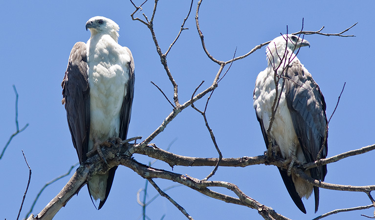
White-bellied sea eagle (Haliaeetus leucogaster)
White-bellied sea eagles can be easily identified by their white tail and dark grey wings. These raptors are often spotted cruising the coastal breezes throughout Australia, and make for some scenic bird watching. Powerful Australian birds of prey, they are known to mate for life, and return each year to the same nest to breed.
Plants
-

Old man banksia (Banksia serrata)
Hardy Australian native plants, old man banksias can be found along the coast, and in the dry sclerophyll forests and sandstone mountain ranges of NSW. With roughened bark and gnarled limbs, they produce a distinctive cylindrical yellow-green banksia flower which blossoms from summer to early autumn.
-

Smooth-barked apple (Angophora costata)
Smooth-barked apple gums, also known as Sydney red gum or rusty gum trees, are Australian native plants found along the NSW coast, and in the Sydney basin and parts of Queensland. Growing to heights of 15-30m, the russet-coloured angophoras shed their bark in spring to reveal spectacular new salmon-coloured bark.
-

Grass tree (Xanthorrea spp.)
An iconic part of the Australian landscape, the grass tree is widespread across eastern NSW. These Australian native plants have a thick fire-blackened trunk and long spiked leaves. They are found in heath and open forests across eastern NSW. The grass tree grows 1-5m in height and produces striking white-flowered spikes which grow up to 1m long.