Polblue Swamp track
Barrington Tops National Park
Visitor info
All the practical information you need to know about Polblue Swamp track.
Track grading
Features of this track
Distance
3km loop
Time
30min - 1hr
Quality of markings
Sign posted
Experience required
No experience required
Gradient
Gentle hills: The first section of the track from the picnic area has slight slopes uphill and downhill. The rest of the track has more uneven ground, with some steeper sections.
Quality of path
Formed track, some obstacles: The first 100m of the track from the picnic area is step-free and mostly flat, with a mix of hard-packed ground and timber surfaces. After the first 100m, the track becomes more sloped and uneven, with steeper sections.
The track is 1–1.5m wide and may have rocks and tree roots along its length.
Steps
Occasional steps: There are no steps along the first 500m of the walk. There are occasional steps along the rest of the walk.
Getting there and parking
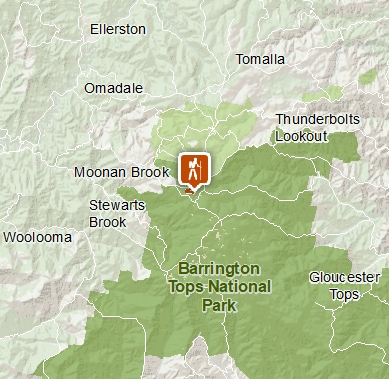
Polblue Swamp track starts at Polblue campground and picnic area in the Polblue and Devils Hole precinct of Barrington Tops National Park. To get there:
From Gloucester:
- Take Thunderbolts Way; this road becomes Scone Road and Barrington Tops Forest Road.
- The campground and picnic area are located on the left after passing Devils Hole
From Scone:
- Take the Hunter road from Scone
- Turn right on to Moonan Brook Road, then turn left on Barrington Tops Forest Road.
- Polblue camping and picnic areas are 7km on the right after the Dingo Gate
Parking
There's a gravel carpark at Polblue campground and picnic area where this walk begins.
Best times to visit
There are lots of great things waiting for you in Barrington Tops National Park. Here are some of the highlights.
Autumn
Take to the park's walking tracks to make the most of cooler and drier daytime weather.
Spring
Look out for ground orchids and other wildflowers along the Polblue Swamp walking track.
Summer
Look out for the eastern water dragon basking on rocks around the streams.
Maps and downloads
Accessibility
Disability access level - hard
The first 500m of track is step-free and 1–1.5m wide, with gentle slopes and a mixture of hard-packed ground and timber surfaces. There may be tree roots and rocks along the track.
After the first 500m, the track becomes steeper, more uneven and narrower in places. There may be occasional steps.
Prohibited
Pets
Pets and domestic animals (other than certified assistance animals) are not permitted. Find out which regional parks allow dog walking and see the pets in parks policy for more information.
Smoking
NSW national parks are no smoking areas.
Operated by
- Gloucester office
- Monday to Friday, 8.30am to 4.30pm.
- 02 6538 5300
- npws.barringtontops@environment.nsw.gov.au
- 59 Church Street, Gloucester NSW 2422
Park info
- in Barrington Tops National Park in the North Coast and Country NSW regions
Barrington Tops National Park is always open but may have to close at times due to poor weather or fire danger.