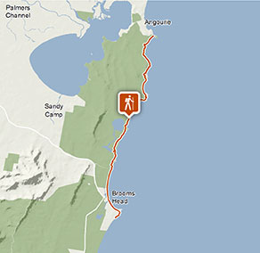
Angourie to Brooms Head walking track
Yuraygir National Park
Visitor info
All the practical information you need to know about Angourie to Brooms Head walking track.
Track grading
Features of this track
Distance
18km one-way
Time
6 - 7hrs
Quality of markings
Sign posted
Experience required
Experienced bushwalkers
Gradient
Short steep hills
Steps
No steps
Quality of path
Formed track, some obstacles
Getting there and parking
Get driving directions
Angourie is in the northern precinct of Yuraygir National Park. To get there:
- Turn off Pacific Highway at Harwood and follow signs into Yamba
- At the roundabout in Yamba turn right to Angourie
Parking
Car and bus parking is available at Angourie Surfing Reserve, Angourie picnic area, Mara Creek, Lake Arragan and Brooms Head.
Best times to visit
There are lots of great things waiting for you in Yuraygir National Park. Here are some of the highlights.
Autumn
Autumn is the perfect time of year to go beach fishing along the park's coastline.
Spring
The park's heathlands provide a spectacular display of wildflowers. Check them out on your choice of walking track, including the Wilsons Headland walk and, of course, the Yuraygir coastal walk.
Summer
Visit in summer to make the most of the park's countless beaches and waterways. Swim, surf or snorkel – cooling sea breezes provide welcome relief in hot weather.
Winter
Plan a winter trip to go whale watching. The sight of migrating whales swimming north to warmer waters is second-to-none, and there are magnificent viewing points at Red Cliffs lookout and Brooms Head.
Weather, temperature and rainfall
Summer temperature
Average
20°C and 26°C
Highest recorded
42.5°C
Winter temperature
Average
9°C and 20°C
Lowest recorded
2.7°C
Rainfall
Wettest month
March
Driest month
September
The area’s highest recorded rainfall in one day
300mm
Facilities
Toilets
There are toilets at Angourie Bay, Shelley Headland, Lake Arragan and Brooms Head.
Picnic tables
Maps and downloads
Permitted
You’re encouraged to bring gas or fuel stoves, especially in summer during the fire season.
Fishing
A current NSW recreational fishing licence is required when fishing in all waters.
Prohibited
Pets
Pets and domestic animals (other than certified assistance animals) are not permitted. Find out which regional parks allow dog walking and see the pets in parks policy for more information.
Smoking
NSW national parks are no smoking areas.
Operated by
- Grafton office
- Monday to Friday, 8.30am to 4.30pm.
- 02 6641 1500
- npws.clarence@environment.nsw.gov.au
- Level 4, 49 Victoria Street, Grafton NSW 2460
Park info
- in Yuraygir National Park in the North Coast region
Yuraygir National Park is always open but may have to close at times due to poor weather or fire danger.
-
Park entry fees:
$8 per vehicle per day.
Buy annual pass