Historic Nightcap walking track
North Coast
Visitor info
All the practical information you need to know about Historic Nightcap walking track.
Track grading
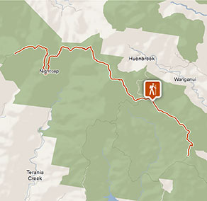
Features of this track
Distance
18km one-way
Time
1 - 2 days
Quality of markings
Sign posted
Experience required
Experienced bushwalkers
Gradient
Very steep
Steps
No steps
Quality of path
Rough track, many obstacles
Getting there and parking
Historic Nightcap walking track is in the western precinct of Nightcap National Park. To get there:
From Nimbin:
- Take Sibley Street and drive past Nimbin Bowling Club
- Turn onto Gungas Street and continue for 1.5km, then turn right onto Tuntable Falls Road - signposted ‘Mount Nardi’.
- Travel a further 4.2km, past Upper Tuntable Falls Road intersection, where the road turns onto Newton Drive.
- Continue for approximately 4.8km to the park entrance, and another 1km to Mount Nardi carpark.
From the eastern park entrance (via Rosebank):
- Take Minyon Drive, past Minyon Falls picnic area, over the causeway.
- Continue along Minyon Drive until you reach the Peates Mountain Road intersection
- Turn right onto Peates Mountain Road – the track is approximately 100m to the north (approximately 4km).
From the southern park entrance on Nightcap Range Road (via Dunoon):
- Continue north up Nightcap Range Road to the top of the range
- Turn left onto Peates Mountain Road – the track is approximately 100m north (approximately 5km).
Parking
Parking is available at Mount Nardi carpark.
Best times to visit
There are lots of great things waiting for you in Nightcap National Park. Here are some of the highlights: Weather in the northern rivers region is generally mild in winter ranging to hot in summer. It can be very wet (the park receives the highest annual rainfall in NSW) and misty so check local weather conditions and pack suitable clothes as well as a hat, sunscreen and insect repellent.
Weather, temperature and rainfall
Summer temperature
Average
18°C and 29°C
Highest recorded
40°C
Winter temperature
Average
6°C and 19°C
Lowest recorded
-0.6°C
Rainfall
Wettest month
February
Driest month
September
The area’s highest recorded rainfall in one day
350mm
Facilities
Drinking water
Drinking water is not available in this area, so it’s a good idea to bring your own.
Maps and downloads
Prohibited
Pets
Pets and domestic animals (other than certified assistance animals) are not permitted. Find out which regional parks allow dog walking and see the pets in parks policy for more information.
Smoking
NSW national parks are no smoking areas.
Operated by
- Alstonville office
- Monday to Friday, 8:30am to 4:30pm
- 02 6627 0200
- npws.richmondriver@environment.nsw.gov.au
- Russelton Industrial Estate, 7 Northcott Crescent, Alstonville NSW 2477
Park info
- in Whian Whian State Conservation Area in the North Coast region
Whian Whian State Conservation Area is always open but may have to close at times due to poor weather.
- in Nightcap National Park in the North Coast region
Nightcap National Park is always open but may have to close at times due to poor weather, fire danger or management operations.