Gloucester Tops circuit
Barrington Tops National Park
Overview
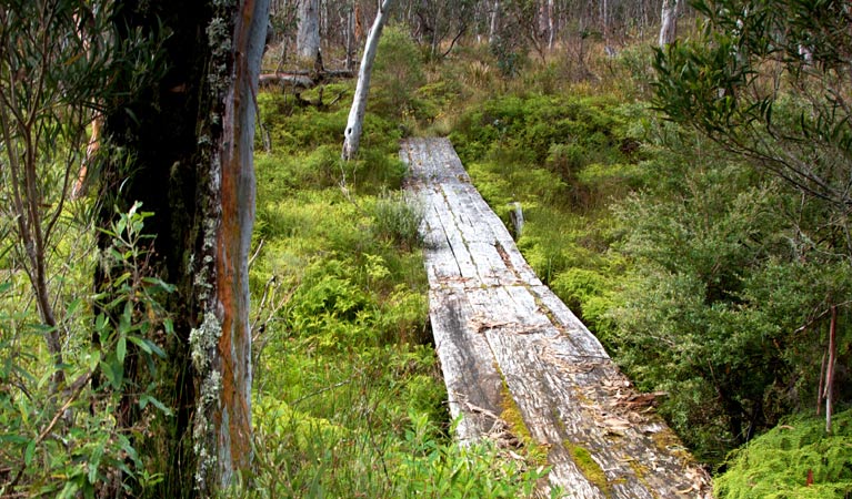
Walk through snow gum woodland and ancient rainforest to lookouts and waterfalls, along the Gloucester Tops circuit. This 8km loop combines 3 popular and scenic walks in Barrington Tops National Park.
- Distance
- 8km loop
- Time suggested
- 3 - 5hrs
- Grade
- Grade 4
- Trip Intention Form
-
It's a good idea to let someone know where you're going. Fill in a trip intention form to send important details about your trip to your emergency contact.
- What to
bring - Hat, sunscreen, drinking water
- Please note
- Check the weather before setting out as the road to Gloucester River and Gloucester Tops may be inaccessible during wet weather.
- Remember to take your binoculars if you want to birdwatch
Gloucester Tops circuit is an excellent option for a shorter day walk, and is a great walk to get a sense of the astonishing diversity within the Gloucester Tops area of Barrington Tops National Park.
Set out from Gloucester Falls picnic area along Gloucester Falls walking track. You’ll walk through open snow gum woodland to Andrew Laurie lookout, on the edge of the escarpment, and on to Gloucester Falls lookout. Join River walking track, and wander amid sub-alpine woodland. Look out for swamp wallabies and grey kangaroos along this walk. In summer, bluebells, rice flowers and billy buttons are an extra treat. You'll then meet, Antarctic Beech Forest walking track, which features cool temperate rainforest with the canopy of Antarctic beech towering above the tree ferns and damp carpet of moss on the forest floor.
As you walk each track together or individually, keep in mind that you are walking through part of the Gondwana Rainforests of Australia. This landscape is millions of years old and plays a critical role in protecting rare and threatened species and sustaining vital resources.
Map
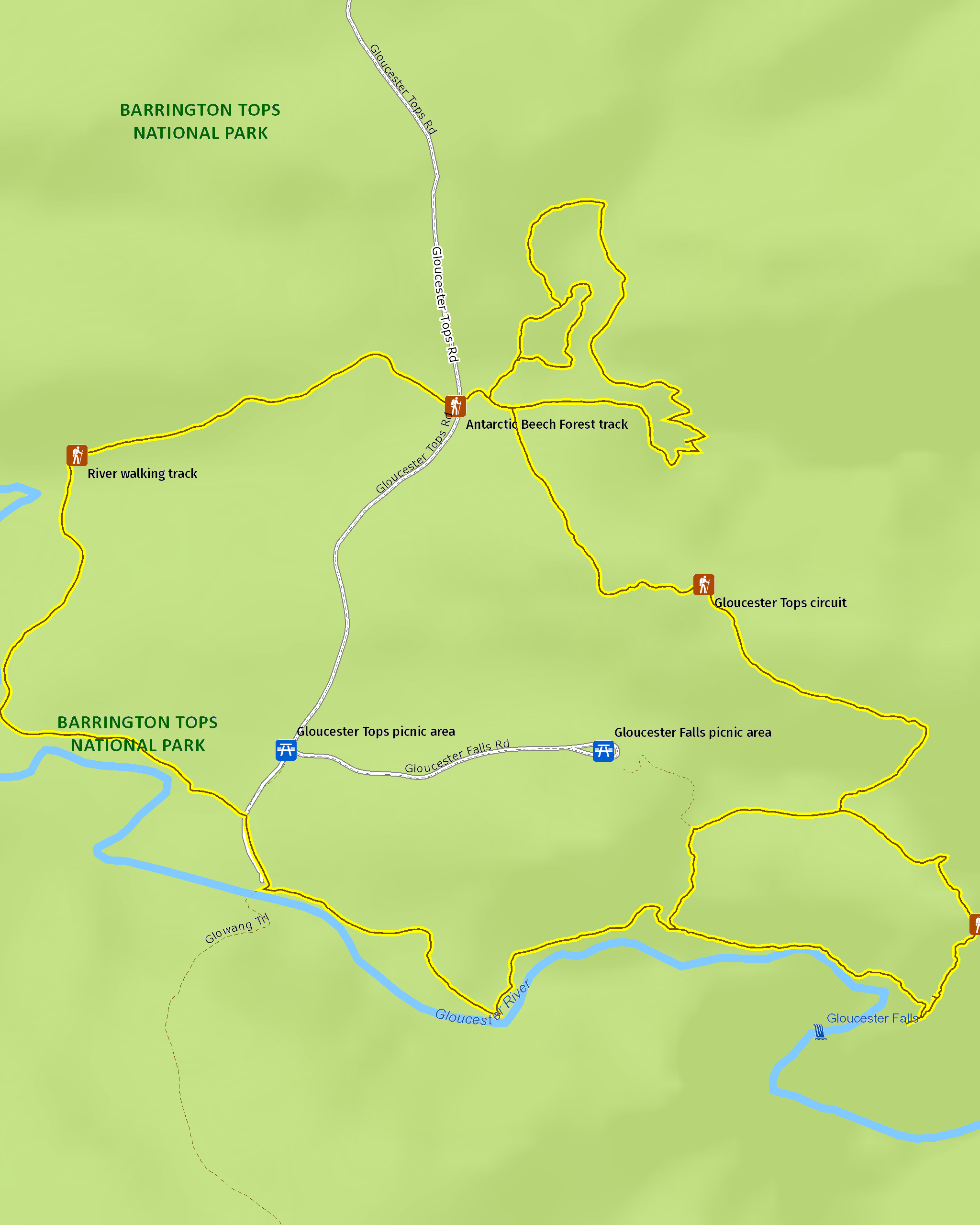
Map
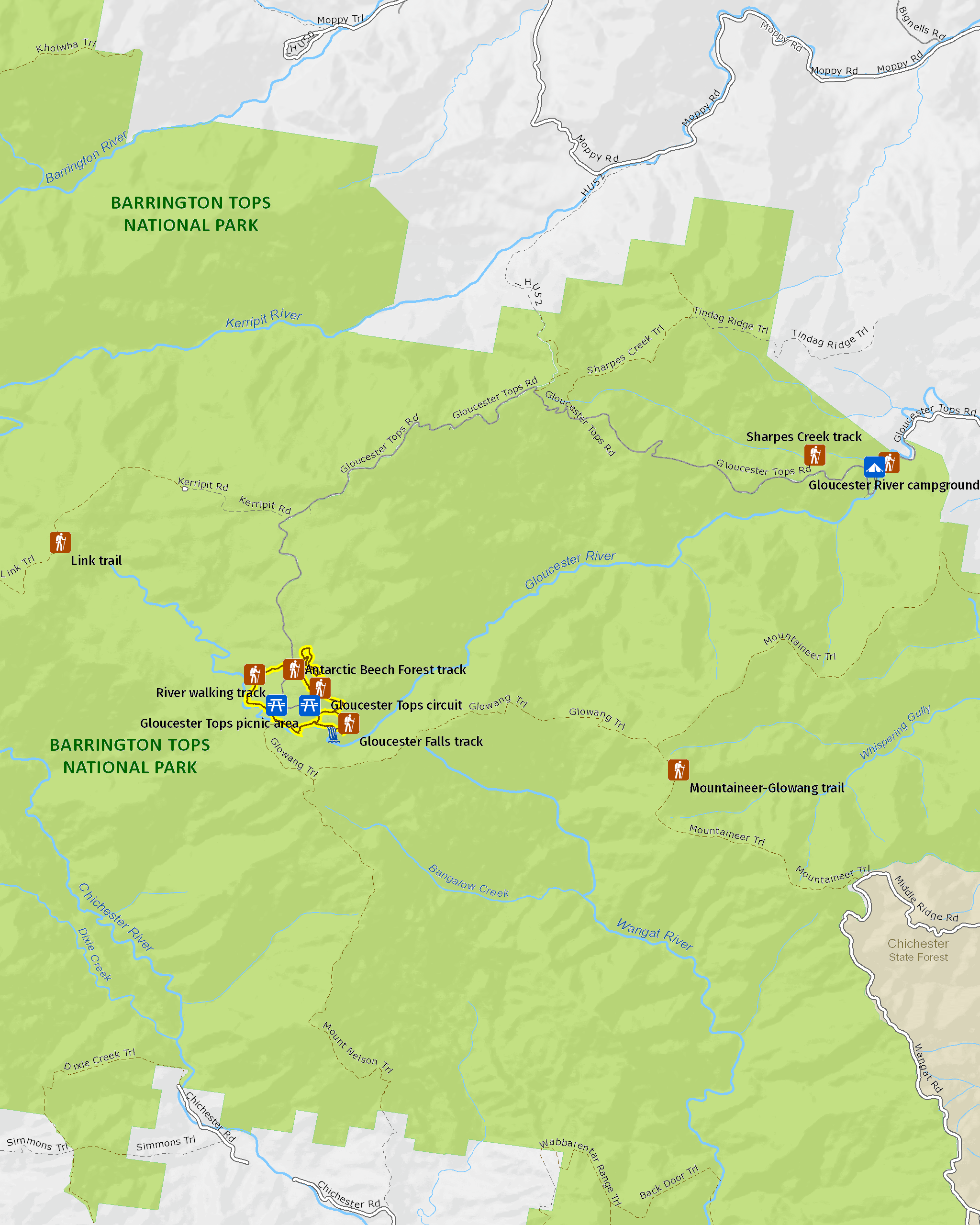
Map legend

Local alerts
For the latest updates on fires, closures and other alerts in this area, see https://www.nationalparks.nsw.gov.au/things-to-do/walking-tracks/gloucester-tops-circuit/local-alerts
General enquiries
- National Parks Contact Centre
- 7am to 7pm daily
- 1300 072 757 (13000 PARKS) for the cost of a local call within Australia excluding mobiles
- parks.info@environment.nsw.gov.au
Park info
- in Barrington Tops National Park in the North Coast and Country NSW regions
Barrington Tops National Park is always open but may have to close at times due to poor weather or fire danger.
Visitor info
All the practical information you need to know about Gloucester Tops circuit.
Maps and downloads
Learn more
Gloucester Tops circuit is in Barrington Tops National Park. Here are just some of the reasons why this park is special:
World Heritage-listed rainforests

The rainforests in Barrington Tops National Park are part of the Gondwana Rainforests of Australia World Heritage Area; the most extensive strip of diverse rainforest anywhere on earth. The World Heritage Area is a direct window into the past and the future, providing a link to the ancient pre-human world and a stunning and irreplaceable record of life on our planet. You can explore the rainforest on one of the park's many walking tracks, like the Honeysuckle Forest track, the Rocky Crossing walk or the Antarctic Beech Forest track. Listen out for the lyrebird whose mimicking calls ring out through the rainforest.
- Antarctic Beech Forest walking track Antarctic Beech Forest walking track offers rainforest, cascades, scenic views, and birdwatching in Barrington Tops National Park, near Gloucester.
- Barrington Tops guided full-day hike Join Endless Adventure Travel on a full-day guided hike in Barrington Tops National Park. You’ll walk 17km through lush ancient rainforest with stunning cascade waterfalls.
- Careys Peak walking track Easy Careys Peak walking track offers picnicking, scenic views, birdwatching, and historic heritage in the sub-alpine region of Barrington National Park, near Scone.
- Cobark Park picnic area Take a break at Cobark Park picnic area to plan your adventures in the plateau region of Barrington Tops National Park—1 hour from Gloucester.
An ancient landscape

Barrington Tops National Park and the adjoining State Conservation Area are the traditional lands of Biripi, Worimi, Guringai, Geawegal and Wonaruah People. The rainforests of Barrington Tops offered a wealth of resources for Aboriginal people, including many edible fruits, like the native cherry, lilly pilly and figs. Today, the history of Aboriginal people in Barrington Tops is recorded in oral history and in the presence of Aboriginal sites. Barrington Tops National Park protects ancient campsites, scarred trees and sacred ceremonial places.
A dramatic wilderness

Most of Barrington Tops National Park is declared wilderness; large, natural areas of land that, together with their native plants and animal communities, remain essentially unchanged by modern human activity. Wilderness areas in NSW represent the largest, most pristine natural areas within NSW - the last of Australia's wild and untamed places. The edges of the wilderness area of Barrington Tops are easily accessible; some of the most spectacular views in the park are from Careys Peak and Devils Hole and Thunderbolts lookouts. You'll notice the varied textures of the forest below you, with the ranges of the Barrington Wilderness running east and south from the plateau like the fingers of an outstretched hand.
- Barrington trail Take the challenge of the Barrington trail, a 4WD trail in Barrington Tops National Park. Open between October and May every year, plan your 4WD camping holiday now.
- Gloucester Tops circuit Walk through snow gum woodland and ancient rainforest to lookouts and waterfalls, along the Gloucester Tops circuit. This 8km loop combines 3 popular and scenic walks in Barrington Tops National Park.
- Majestic Barrington mountain bike tours Enjoy spectacular scenery as you cycle through Barrington Tops National Park and beyond on this supported mountain bike tour with Aussie Bike or Hike, near Gloucester.
- Rocky Crossing walk Rocky Crossing walk along Williams River offers scenic rainforest views, wildlife and birdwatching on a long easy track in Barrington Tops National Park, near Dungog.
Plants and animals protected in this park
Animals
-

Superb lyrebird (Menura novaehollandiae)
With a complex mimicking call and an elaborate courtship dance to match, the superb lyrebird is one of the most spectacular Australian animals. A bird watching must-see, the superb lyrebird can be found in rainforests and wet woodlands across eastern NSW and Victoria.
-

Swamp wallaby (Wallabia bicolor)
The swamp wallaby, also known as the black wallaby or black pademelon, lives in the dense understorey of rainforests, woodlands and dry sclerophyll forest along eastern Australia. This unique Australian macropod has a dark black-grey coat with a distinctive light-coloured cheek stripe.
-

Bare-nosed wombat (Vombatus ursinus)
A large, squat marsupial, the Australian bare-nosed wombat is a burrowing mammal found in coastal forests and mountain ranges across NSW and Victoria. The only other remaining species of wombat in NSW, the endangered southern hairy-nosed wombat, was considered extinct until relatively recently.
-

Australian brush turkey (Alectura lathami)
The Australian brush turkey, also known as bush or scrub turkey, can be found in rainforests along eastern NSW. With a striking red head, blue-black plumage and booming call, these distinctive Australian birds are easy to spot while bird watching in several NSW national parks.
-

Common ringtail possum (Pseudocheirus peregrinus)
Commonly found in forests, woodlands and leafy gardens across eastern NSW, the Australian ringtail possum is a tree-dwelling marsupial. With a powerful tail perfectly adapted to grasp objects, it forages in trees for eucalypt leaves, flowers and fruit.
-

Rufous scrub-bird (Atrichornis rufescens)
The vulnerable rufous scrub-bird is a small, ground-foraging bird that lives only in isolated rainforest areas of south-eastern Australia.