Bald Rock Summit walk
Bald Rock National Park
Visitor info
All the practical information you need to know about Bald Rock Summit walk.
Track grading
Features of this track
Distance
2.7km return
Time
2hrs
Quality of markings
Sign posted
Experience required
Experienced bushwalkers
Gradient
Very steep and difficult
Steps
Occasional steps
Quality of path
Formed track, some obstacles
Getting there and parking
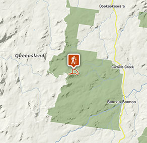
Bald Rock Summit walk begins from the main visitor area in Bald Rock National Park. To get there:
From Tenterfield:
- Turn right at the northern end of town onto sealed Woodenbong Road
- Continue for 29km, passing Boonoo Boonoo National Park and Boonoo Boonoo River
- Follow the sealed Bald Rock Road for 5km to Bald Rock campground and picnic area.
From Stanthorpe:
- Take the road to Amosfield, then turn south towards Tenterfield along the unsealed section of Woodenbong Road
- Crossing Mursons and Jenner Creek, continue past Bald Rock Bush Retreat for 5km to Bald Rock campground and picnic area.
Road quality
Check the weather before you set out as the road to Bald Rock can be closed during extreme events such as flooding and bushfires.
Parking
Car and bus parking is available. It can be a busy place on the weekend, so parking might be limited then.
Best times to visit
There are lots of great things waiting for you in Bald Rock National Park. Here are some of the highlights.
Autumn
Clear crisp atmosphere at this time of year offers outstanding views from the top of Bald Rock.
Spring
Wildflowers and the mild temperatures make spring a fantastic time of year for long walks and camping out.
Summer
Good camping weather as the temperature rarely exceeds 30 degrees.
Winter
Frosts and rare snow flakes overnight, followed by brilliant blue skies overhead and crisp, fresh sunny days.
Weather, temperature and rainfall
Summer temperature
Average
25°C and 28°C
Highest recorded
38.8°C
Winter temperature
Average
15°C and 18°C
Lowest recorded
-10°C
Rainfall
Wettest month
January
Driest month
August
The area’s highest recorded rainfall in one day
228.6mm
Facilities
- Drinking water is not available in this area, so it’s a good idea to bring your own.
Maps and downloads
Accessibility
Disability access level - no wheelchair access
Prohibited
Cycling
Pets
Pets and domestic animals (other than certified assistance animals) are not permitted. Find out which regional parks allow dog walking and see the pets in parks policy for more information.
Smoking
NSW national parks are no smoking areas.

Operated by
- Glen Innes office
- Monday to Friday, 8.30am to 4.30pm.
- 02 6739 0700
- npws.ntab@environment.nsw.gov.au
- 68 Church Street, Glen Innes NSW 2370
Park info
- in Bald Rock National Park in the Country NSW region
Bald Rock National Park is always open but may have to close at times due to poor weather or fire danger.
-
Park entry fees:
$8 per vehicle per day. The park uses a self-registration fee collection system. Please bring the correct change.
Buy annual pass
