Harbour Bridge to The Spit Bridge walking track
Sydney Harbour National Park
Open, check current alerts
Overview
Tread the paths of history past Taronga Zoo and federation homes on The Harbour Bridge to Spit Bridge walk. Be enthralled in beautiful bushland and rainforest remnants.
- Distance
- 16.5km one-way
- Time suggested
- 5 - 6hrs
- Grade
- Grade 3
- Trip Intention Form
-
It's a good idea to let someone know where you're going. Fill in a trip intention form to send important details about your trip to your emergency contact.
- Opening times
Harbour Bridge to Spit Bridge walking track is always open but may need to close at times due to poor weather or fire danger.
- What to
bring - Drinking water, hat, sunscreen
- Please note
- You might like to pack swimmers and a towel as there are opportunities to swim along the way
- Take care as this walk includes a variety of terrain and pathway conditions
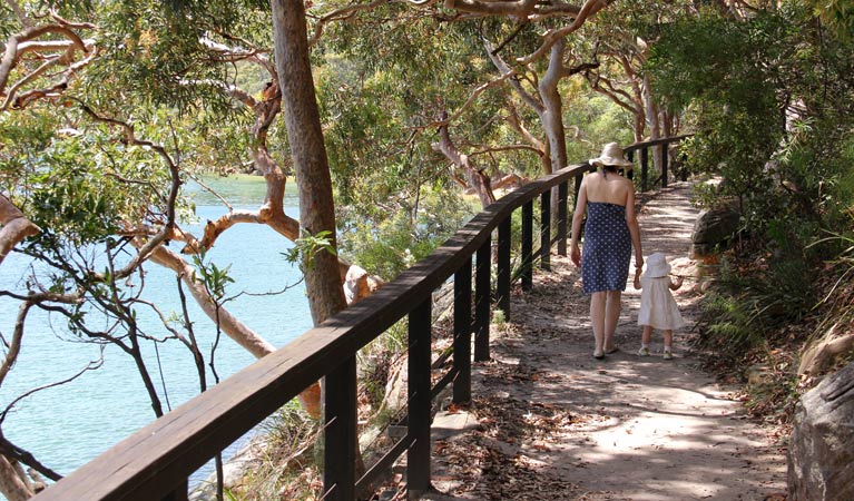
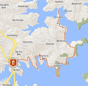
This stunning urban foreshore walk begins at the Sydney Harbour Bridge. Start at the bridge’s southern end in The Rocks or its northern end at Milsons Point, and then follow its signage around the harbour’s northern shores.
On this superbly scenic route, you’ll tread the paths of history as you pass harbour fortifications and Federation homes. You’ll walk some of the city’s most interesting and exclusive streets and find yourself ensconced in beautiful bushland and rainforest remnants.
Hike east past Taronga Zoo and into Sydney Harbour National Park, home of the incredible Bradleys, Chowder and Middle Heads. Be sure to stop at Athol Hall for a cuppa and a bite to eat, before continuing on to the exquisite Balmoral Beach for a swim. Then press on until you reach The Spit Bridge; you may even get there in time to see it open and rise to allow boats through.
It’s easy to break this walk up into shorter sections by parking partway along the route, catching the bus or the ferry at Mosman or Taronga Zoo wharves.
This walk forms part of The Bondi to Manly Walk, an 80km multi-day coastal hike that connects 2 of Sydney’s most famous surf beaches.
Sydney native habitats in 360
Explore our 360-degree interactive national park habitats in and around Sydney's urban fringe, and the protected plants and animals that live here.

Bundle:
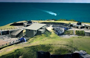
Middle Head and Georges Head Fort: Sydney's coastal defence
Watch a series of animations to see the range of the guns in action at Middle Head and Georges Head.
General enquiries
- National Parks Contact Centre
- 7am to 7pm daily
- 1300 072 757 (13000 PARKS) for the cost of a local call within Australia excluding mobiles
- parks.info@environment.nsw.gov.au
Operated by
- Middle Head office
- Monday to Friday, 9.30am to 4pm.
- 02 9960 6266
- npws.sydneynorth@environment.nsw.gov.au
- 2 Governors Road, Mosman NSW 2088
Park info
- in Sydney Harbour National Park in the Sydney and surrounds region
Sydney Harbour National Park is open sunrise to sunset but may have to close at times due to poor weather or fire danger.
-
Park entry fees:
Bradleys Head: $8 per vehicle per day. North Head: $5 per vehicle per day. Tap and pay card or phone payments accepted at pay machines. Coin payment available at Fairfax carpark machines only. Chowder Bay: Monday-Friday: $3 per hour, to a maximum of $16 per day. Saturday, Sunday and Public Holidays: $4 per hour, to a maximum of $20 per day. If you hold an NPWS All Parks or Multi Parks Pass, you can park free for up to four hours per day - additional time can be purchased. Car parks operated by Sydney Harbour Federation Trust or Mosman Council are not covered by your pass. Please check signs carefully. Park’nPay: You can also pay for your visit to any area via the Park’nPay app.
Other fees:
Landing fees or tour fees apply to visit Sydney Harbour islands. All public visitors to Shark, Clark or Rodd Island, need to pay a $7 per person landing fee. To arrange, please contact 1300 072 757 (13000 PARKS). Annual NSW Parks Passes do not cover landing fees.
Buy annual pass
What's nearby:
Things to do (103)
- Aboriginal culture (7)
- Beach (3)
- Birdwatching and wildlife encounters (18)
- Cafes and kiosks (3)
- Canoeing/paddling (14)
- Cycling (6)
- Fishing (6)
- Historic heritage (37)
- Horse riding (2)
- Other experiences (2)
- Picnics and barbecues (33)
- Sailing, boating and cruises (6)
- Sightseeing (36)
- Snorkelling and scuba (3)
- Swimming (12)
- Walking (30)
- Waterfalls (2)
- Wildflowers (seasonal) (2)