Wondabyne to Patonga walking track
Brisbane Water National Park
Overview
Part of Great North walk, Wondabyne to Patonga walking track is an overnight walk through NSW Central Coast bushland. It offers great Hawkesbury River views and birdwatching.
- Distance
- 23km one-way
- Time suggested
- 8 - 9hrs
- Grade
- Grade 4
- Trip Intention Form
-
It's a good idea to let someone know where you're going. Fill in a trip intention form to send important details about your trip to your emergency contact.
- Entry fees
- Park entry fees apply
- Opening times
Wondabyne to Patonga walking track is always open, but may have to close at times due to poor weather or fire danger.
- What to
bring - Sunscreen, hat
- Please note
- Remember to take your binoculars if you want to go birdwatching.
- There is limited mobile reception in this park.
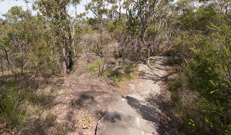
Wondabyne to Patonga walking track is part of the renowned Great North walk, and is an absolute must for experienced bushwalkers and campers keen to explore Brisbane Water National Park. Starting at Wondabyne railway station, this challenging rough track winds through superb grassy woodlands, rainforest and coastal heath.
Soak up spectacular views over Brisbane Water, Broken Bay and Hawkesbury River and stop for a swim near Kariong Brook waterfall; particularly impressive after rain. Pitch your tent at remote Mount Wondabyne bush campground – be sure to look for the fire circle near the base of the mountain.
Birdwatching enthusiasts are spoilt for choice all year round, so keep an eye out for cockatoos, brush turkeys and owls. You may even spot a koala in one of the grey gums. Upon reaching Patonga, take the ferry to Palm Beach or the bus to Woy Woy or Gosford.
Map
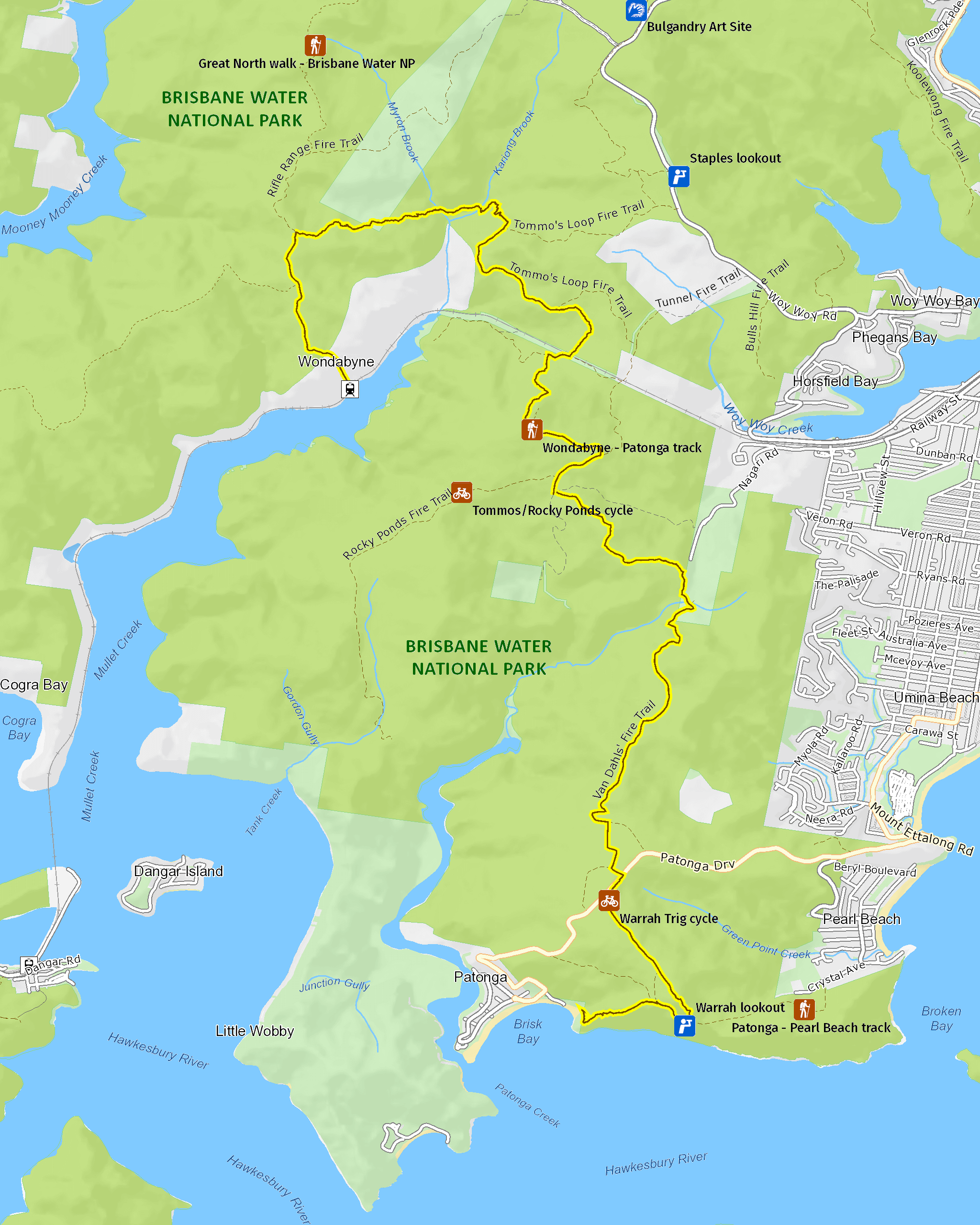
Map legend

Local alerts
For the latest updates on fires, closures and other alerts in this area, see https://www.nationalparks.nsw.gov.au/things-to-do/walking-tracks/wondabyne-to-patonga-walking-track/local-alerts
General enquiries
- National Parks Contact Centre
- 7am to 7pm daily
- 1300 072 757 (13000 PARKS) for the cost of a local call within Australia excluding mobiles
- parks.info@environment.nsw.gov.au
Park info
- in Brisbane Water National Park in the Sydney and surrounds region
Two picnic areas in this park – Girrakool picnic area and Somersby Falls picnic area – are closed in the evening. They are open 7am to 8pm during daylight savings and 7am to 6pm at other times.
Other areas of Brisbane Water National Park will be open at all times, however may have to close at times due to poor weather or fire danger.
-
Park entry fees:
$8 per vehicle per day. The park has pay machines that accept cards, or you can pay via the Park'nPay app.
Other fees:
You will need a permit to hold a wedding or undertake commercial photography within the park.
Buy annual pass.
Visitor info
All the practical information you need to know about Wondabyne to Patonga walking track.
Maps and downloads
Learn more
Wondabyne to Patonga walking track is in Brisbane Water National Park. Here are just some of the reasons why this park is special:
A haven for wildlife

Brisbane Water National Park is home to an incredible 270 native animal species. Keep your eyes peeled for wildlife and bird life such as the threatened spotted tailed quoll, the rare glossy black cockatoo and powerful owl. You might be lucky enough to share a picnic at Girrakool picnic area with a few wallabies who love this peaceful place.
- Brisbane Water Aboriginal cultural tour These school holidays, join an Aboriginal ranger on a family friendly guided tour in Brisbane Water National Park. Hear cultural stories as you walk along Doyles walking track, near Patonga.
- Girrakool loop track A lovely way to finish a barbecue, the Girrakool loop track is a short and easy walk through bushland, featuring an Aboriginal rock engraving site and scenic waterfalls.
- Great North walk stage 8: Waratah spectacular Panoramic views of Sydney’s northern coastline await you on stage 8 of the Great North walk. The 20km guided tour through Brisbane Water National Park starts at Patonga and ends at Wondabyne Station.
- Great North walk stage 9: Rainforest walk Stage 9 of the Great North walk takes you into the temperate rainforest of Brisbane Water National Park. The 16km guided tour starts at Wondabyne Station and ends at Kariong.
- Somersby Falls picnic area A great place to picnic on the Central Coast, Somersby Falls picnic area is wheelchair accessible and offers barbecues and picnic tables in a lush rainforest setting, with waterfalls and a walking track.
A wonderland of wildflowers

Located 12km from Gosford, the park covers 12,000ha of rugged sandstone country, and boarders the Hawkesbury river, which feeds cascading waterfalls. The landscape is gorgeous all year round, especially from late winter to early spring when it comes alive with colourful wildflowers.
- Brisbane Water Aboriginal cultural tour These school holidays, join an Aboriginal ranger on a family friendly guided tour in Brisbane Water National Park. Hear cultural stories as you walk along Doyles walking track, near Patonga.
- Great North walk stage 10: Brisbane Water dreaming Complete the Great North walk challenge with the tenth and final leg of the series. You’ll walk 18km from Kariong to Somersby, exploring the serene waterways of Brisbane Water National Park.
- Great North walk stage 8: Waratah spectacular Panoramic views of Sydney’s northern coastline await you on stage 8 of the Great North walk. The 20km guided tour through Brisbane Water National Park starts at Patonga and ends at Wondabyne Station.
- Great North walk stage 9: Rainforest walk Stage 9 of the Great North walk takes you into the temperate rainforest of Brisbane Water National Park. The 16km guided tour starts at Wondabyne Station and ends at Kariong.
- Warrah lookout Warrah lookout, offering scenic views of Broken Bay and the Hawkesbury River, is just a short walk from the carpark. It’s a great place to see Waratahs in season.
Ancient landscapes

Aboriginal people in the area have a long association with the landscape of Brisbane Water National Park and much evidence of this remains today in the form of rock engravings, foreshore middens and rock paintings. The flat, exposed areas of Hawkesbury sandstone within the park provide an ideal 'canvas' for Aboriginal artists, and there are hundreds of rock engraving sites throughout the park. Aboriginal sites on Hawkesbury sandstone have a distinctive style of engraving which is unique in Australia. The Bulgandry Aboriginal engraving site at Kariong is an excellent example of rock art within the park and is easily accessible.
- Aboriginal culture Bring your students to this unique excursion in Brisbane Water National Park, near Gosford. They’ll experience the park through the eyes of an Aboriginal person on this Stage 2 (Years 3-4) Aboriginal culture Geography excursion.
- Brisbane Water Aboriginal cultural tour These school holidays, join an Aboriginal ranger on a family friendly guided tour in Brisbane Water National Park. Hear cultural stories as you walk along Doyles walking track, near Patonga.
- Girrakool loop track A lovely way to finish a barbecue, the Girrakool loop track is a short and easy walk through bushland, featuring an Aboriginal rock engraving site and scenic waterfalls.
- Somersby Falls picnic area A great place to picnic on the Central Coast, Somersby Falls picnic area is wheelchair accessible and offers barbecues and picnic tables in a lush rainforest setting, with waterfalls and a walking track.
- Somersby Falls walking track Somersby Falls walking track in Brisbane Water National Park runs through rainforest to the bottom of Somersby Falls. It starts at Somersby Falls picnic area, a popular Central Coast rest stop near Gosford.
Stretch your legs

Brisbane Water National Park offers great ways to get amongst nature. Why not hop on your mountain bike and get your adrenalin pumping along the Tommos loop and Rocky Ponds cycling route? Or you can wear out your walking shoes along the Girrakool loop walking track. For the more energetic, the park is a hikers delight. Longer treks range from an hour or two to overnight on sections of the Great North walk, which passes through the park on its way from Sydney to Newcastle.
- Girrakool picnic area A great spot for a family picnic, Girrakool picnic area has barbecues, lots of green space to run around and a scenic walking track that features Aboriginal engravings.
- Great North walk - Brisbane Water National Park You’ll find the Wondabyne to Patonga and Patonga to Pearl Beach parts of the iconic Great North walk in Brisbane Water National Park. Take a short walk or overnight hike.
Plants and animals protected in this park
Animals
-

Australian pelican (Pelecanus conspicillatus)
The curious pelican is Australia’s largest flying bird and has the longest bill of any bird in the world. These Australian birds are found throughout Australian waterways and the pelican uses its throat pouch to trawl for fish. Pelicans breed all year round, congregating in large colonies on secluded beaches and islands.
-

Koala (Phascolarctos cinereus)
One of the most renowned Australian animals, the tree-dwelling marsupial koala can be found in gum tree forests and woodlands across eastern NSW, Victoria and Queensland, as well as in isolated regions in South Australia. With a vice-like grip, this perhaps most iconic but endangered Australian animal lives in tall eucalypts within a home range of several hectares.
-

Platypus (Ornithorhynchus anatinus)
One of the most fascinating and unusual Australian animals, the duck-billed platypus, along with the echidna, are the only known monotremes, or egg-laying mammals, in existence. The platypus is generally found in permanent river systems and lakes in southern and eastern NSW and east and west of the Great Dividing Range.
Plants
-

Scribbly gum (Eucalyptus haemastoma)
Easily identifiable Australian native plants, scribbly gum trees are found throughout NSW coastal plains and hills in the Sydney region. The most distinctive features of this eucalypt are the ‘scribbles’ made by moth larva as it tunnels between the layers of bark.
-

Waratah (Telopea speciosissima)
The beautiful waratah is not only the NSW floral emblem, it's also one of the best-known Australian native plants. This iconic Australian bush flower can be found on sandstone ridges around Sydney, in nearby mountain ranges and on the NSW South Coast. The waratah has a vibrant crimson flowerhead, measuring up to 15cm across, and blossoms in spring.