Overview
This exciting cycling route follows the ridge between Patonga and Pearl Beach in Brisbane Water National Park, taking in scenic views and local wildlife.
- Distance
- 10km loop
- Time suggested
- 3hrs
- Grade
- Medium
- Entry fees
- Park entry fees apply
- What to
bring - Drinking water, sunscreen, hat
- Please note
- There are no facilities at Warrah Trig so make sure to bring water and snacks
- Riding is permitted on roads and fire trails only, not on walking tracks. If you are using a walking track at any point, please dismount and walk your bike.
This cycling loop takes in the best the national park has to offer, crossing several fire trails and pausing for scenic views at Warrah lookout. With so much ground to cover, feel free to do as much or as little as you like. Be sure to make time for birdwatching though, or a relaxing picnic lunch among the famous wildflowers. And keep an eye out for animals – with 270 native species in the park, there’s a good chance you’ll come across at least a kangaroo, and maybe even a koala.
Start at Warrah Trig and pedal furiously to Patonga Drive. Tear down Sani Depot and Van Dahls trails, admiring the wildflowers that are scattered along the way. Once you get back to Patonga Drive, you’ll tackle an exciting downhill run to beautiful Pearl Beach, where the Patonga trail will lead you to the Warrah lookout and spectacular views up Hawkesbury River. If hiking is more your style, check out the nearby Patonga to Pearl Beach walking track.
Map
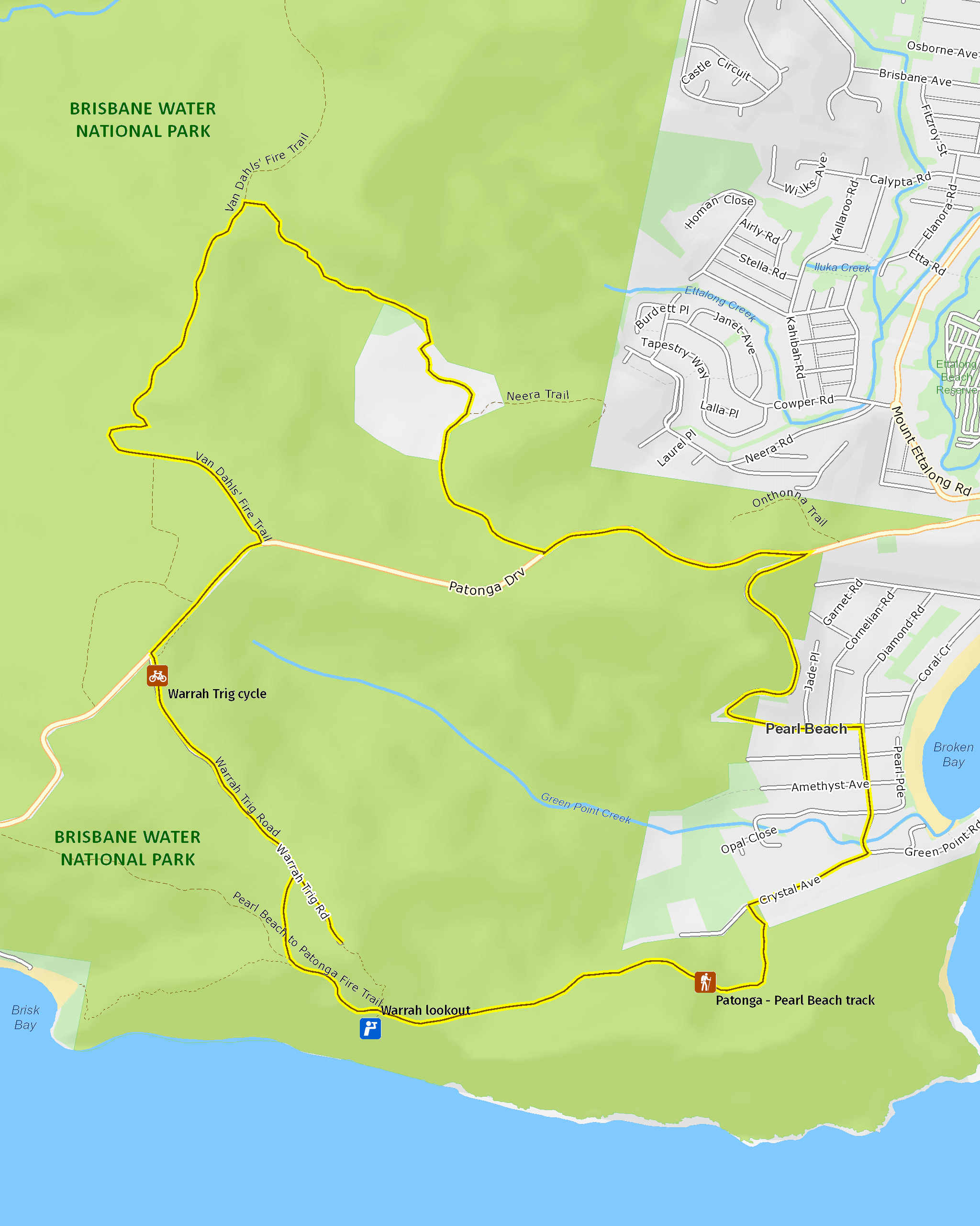
Map legend

Local alerts
For the latest updates on fires, closures and other alerts in this area, see https://www.nationalparks.nsw.gov.au/things-to-do/cycling-trails/warrah-trig-cycling-loop/local-alerts
General enquiries
- National Parks Contact Centre
- 7am to 7pm daily
- 1300 072 757 (13000 PARKS) for the cost of a local call within Australia excluding mobiles
- parks.info@environment.nsw.gov.au
Park info
- in Brisbane Water National Park in the Sydney and surrounds region
Two picnic areas in this park – Girrakool picnic area and Somersby Falls picnic area – are closed in the evening. They are open 7am to 8pm during daylight savings and 7am to 6pm at other times.
Other areas of Brisbane Water National Park will be open at all times, however may have to close at times due to poor weather or fire danger.
-
Park entry fees:
$8 per vehicle per day. The park has pay machines that accept cards, or you can pay via the Park'nPay app.
Other fees:
You will need a permit to hold a wedding or undertake commercial photography within the park.
Buy annual pass.
Visitor info
All the practical information you need to know about Warrah Trig cycling loop.
Getting there and parking
Get driving directions
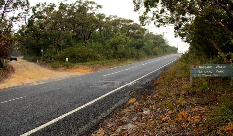
Warrah Trig, where the route begins, is in Brisbane Water National Park. To get there:
- Follow Patonga Drive from Umina Beach
- Warrah Trig Road is on the left-hand side at the crest of the hill, 2.5km beyond the Pearl Beach turnoff.
- Follow the road to the end carpark, where a track leads up to Warrah Trig.
Parking
Parking is available at the end of Warrah Trig Road.
Best times to visit
There are lots of great things waiting for you in Brisbane Water National Park. Here are some of the highlights.
Autumn
The cooler weather makes it a perfect time to find a waterfall walking track, and keep an eye out for ancient Aboriginal engravings along the way.
Spring
Pack a picnic lunch and soak up the delightful sights and sounds of spring. Relax among the wildflowers and wildlife as the Hawkesbury River flows by.
Summer
Take advantage of the warmer summer weather and paddle down Patonga Creek or Mooney Mooney Creek in a canoe.
Weather, temperature and rainfall
Summer temperature
Average
15°C and 27°C
Highest recorded
43.8°C
Winter temperature
Average
5°C and 19°C
Lowest recorded
-4.2°C
Rainfall
Wettest month
March
Driest month
September
The area’s highest recorded rainfall in one day
218.4mm
Maps and downloads
Prohibited
Pets
Pets and domestic animals (other than certified assistance animals) are not permitted. Find out which regional parks allow dog walking and see the pets in parks policy for more information.
Smoking
NSW national parks are no smoking areas.
Learn more
Warrah Trig cycling loop is in Brisbane Water National Park. Here are just some of the reasons why this park is special:
A haven for wildlife

Brisbane Water National Park is home to an incredible 270 native animal species. Keep your eyes peeled for wildlife and bird life such as the threatened spotted tailed quoll, the rare glossy black cockatoo and powerful owl. You might be lucky enough to share a picnic at Girrakool picnic area with a few wallabies who love this peaceful place.
- Brisbane Water Aboriginal cultural tour These school holidays, join an Aboriginal ranger on a family friendly guided tour in Brisbane Water National Park. Hear cultural stories as you walk along Doyles walking track, near Patonga.
- Girrakool loop track A lovely way to finish a barbecue, the Girrakool loop track is a short and easy walk through bushland, featuring an Aboriginal rock engraving site and scenic waterfalls.
- Somersby Falls picnic area A great place to picnic on the Central Coast, Somersby Falls picnic area is wheelchair accessible and offers barbecues and picnic tables in a lush rainforest setting, with waterfalls and a walking track.
- Somersby Falls walking track Somersby Falls walking track in Brisbane Water National Park runs through rainforest to the bottom of Somersby Falls. It starts at Somersby Falls picnic area, a popular Central Coast rest stop near Gosford.
- The Earth’s environment Join The Earth's environment Geography excursion for Stage 2 (Years 3-4) at Brisbane Water National Park, near Gosford. Students will discover how NSW National Parks safeguards over 10 per cent of land in NSW.
A wonderland of wildflowers

Located 12km from Gosford, the park covers 12,000ha of rugged sandstone country, and boarders the Hawkesbury river, which feeds cascading waterfalls. The landscape is gorgeous all year round, especially from late winter to early spring when it comes alive with colourful wildflowers.
- Brisbane Water Aboriginal cultural tour These school holidays, join an Aboriginal ranger on a family friendly guided tour in Brisbane Water National Park. Hear cultural stories as you walk along Doyles walking track, near Patonga.
- Warrah lookout Warrah lookout, offering scenic views of Broken Bay and the Hawkesbury River, is just a short walk from the carpark. It’s a great place to see Waratahs in season.
Ancient landscapes

Aboriginal people in the area have a long association with the landscape of Brisbane Water National Park and much evidence of this remains today in the form of rock engravings, foreshore middens and rock paintings. The flat, exposed areas of Hawkesbury sandstone within the park provide an ideal 'canvas' for Aboriginal artists, and there are hundreds of rock engraving sites throughout the park. Aboriginal sites on Hawkesbury sandstone have a distinctive style of engraving which is unique in Australia. The Bulgandry Aboriginal engraving site at Kariong is an excellent example of rock art within the park and is easily accessible.
- Aboriginal culture Bring your students to this unique excursion in Brisbane Water National Park, near Gosford. They’ll experience the park through the eyes of an Aboriginal person on this Stage 2 (Years 3-4) Aboriginal culture Geography excursion.
- Brisbane Water Aboriginal cultural tour These school holidays, join an Aboriginal ranger on a family friendly guided tour in Brisbane Water National Park. Hear cultural stories as you walk along Doyles walking track, near Patonga.
- Girrakool loop track A lovely way to finish a barbecue, the Girrakool loop track is a short and easy walk through bushland, featuring an Aboriginal rock engraving site and scenic waterfalls.
- Somersby Falls picnic area A great place to picnic on the Central Coast, Somersby Falls picnic area is wheelchair accessible and offers barbecues and picnic tables in a lush rainforest setting, with waterfalls and a walking track.
- Somersby Falls walking track Somersby Falls walking track in Brisbane Water National Park runs through rainforest to the bottom of Somersby Falls. It starts at Somersby Falls picnic area, a popular Central Coast rest stop near Gosford.
Stretch your legs

Brisbane Water National Park offers great ways to get amongst nature. Why not hop on your mountain bike and get your adrenalin pumping along the Tommos loop and Rocky Ponds cycling route? Or you can wear out your walking shoes along the Girrakool loop walking track. For the more energetic, the park is a hikers delight. Longer treks range from an hour or two to overnight on sections of the Great North walk, which passes through the park on its way from Sydney to Newcastle.
- Girrakool picnic area A great spot for a family picnic, Girrakool picnic area has barbecues, lots of green space to run around and a scenic walking track that features Aboriginal engravings.
- Great North walk - Brisbane Water National Park You’ll find the Wondabyne to Patonga and Patonga to Pearl Beach parts of the iconic Great North walk in Brisbane Water National Park. Take a short walk or overnight hike.
Plants and animals protected in this park
Animals
-

Australian pelican (Pelecanus conspicillatus)
The curious pelican is Australia’s largest flying bird and has the longest bill of any bird in the world. These Australian birds are found throughout Australian waterways and the pelican uses its throat pouch to trawl for fish. Pelicans breed all year round, congregating in large colonies on secluded beaches and islands.
-

Koala (Phascolarctos cinereus)
One of the most renowned Australian animals, the tree-dwelling marsupial koala can be found in gum tree forests and woodlands across eastern NSW, Victoria and Queensland, as well as in isolated regions in South Australia. With a vice-like grip, this perhaps most iconic but endangered Australian animal lives in tall eucalypts within a home range of several hectares.
-

Platypus (Ornithorhynchus anatinus)
One of the most fascinating and unusual Australian animals, the duck-billed platypus, along with the echidna, are the only known monotremes, or egg-laying mammals, in existence. The platypus is generally found in permanent river systems and lakes in southern and eastern NSW and east and west of the Great Dividing Range.
Plants
-

Scribbly gum (Eucalyptus haemastoma)
Easily identifiable Australian native plants, scribbly gum trees are found throughout NSW coastal plains and hills in the Sydney region. The most distinctive features of this eucalypt are the ‘scribbles’ made by moth larva as it tunnels between the layers of bark.
-

Waratah (Telopea speciosissima)
The beautiful waratah is not only the NSW floral emblem, it's also one of the best-known Australian native plants. This iconic Australian bush flower can be found on sandstone ridges around Sydney, in nearby mountain ranges and on the NSW South Coast. The waratah has a vibrant crimson flowerhead, measuring up to 15cm across, and blossoms in spring.