Southern Blue Mountains area
Blue Mountains National Park
Overview
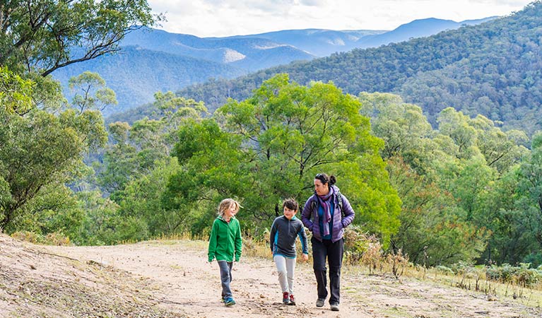
The Southern Blue Mountains area near Oberon is a hidden corner of Blue Mountains National Park. Get off the beaten track and explore remote campgrounds, wilderness walks and 4WD routes. Nearby, Yerranderie historic mining town is a highlight.
Read more about Southern Blue Mountains area
The best way to explore this wild area is along the 4WD Oberon-Colong historic stock route. Pack up the car and follow the unsealed road along the rugged Murruin Range. You’ll get tantalising glimpses of sandstone mesas and the World Heritage Kanangra-Boyd Wilderness next door.
Stop to set up base camp, spread a picnic blanket or stretch your legs at Mount Werong campground. From here you can walk to historic Ruby Creek —you might even have the place to yourself. Longer walks to the pristine Kowmung River will challenge self-sufficient explorers. Or gear up for underground adventures in Colong Caves, if you have caving experience and a permit. Explore the many fire trails by mountain bike or 4WD. The Caves to Caves route, between Jenolan and Wombeyan caves, is a favourite for 4WD touring.
The stock route is the only access to historic Yerranderie Private Town, one of NSW’s most authentic silver mining ghost towns. Book a tour around the preserved settlement and stay onsite at the campground or historic accommodation.
The tall, old growth forest in this area is a sanctuary for wildlife. By day, spot mobs of grey kangaroos, red-necked wallabies, wallaroos, an echidna or large goanna. At night look out for wombats, owls and if you’re lucky, the threatened yellow-bellied glider.
Closer to Katoomba, at the end of the Megalong Valley, you’ll find the open, grassy Dunphys campground. It’s a great base for extended walks along Coxs River or to Kanangra Walls. You can also connect with the 132km Katoomba to Mittagong trail.
Local alerts
For the latest updates on fires, closures and other alerts in this area, see https://www.nationalparks.nsw.gov.au/visit-a-park/parks/southern-blue-mountains-area/local-alerts
Map
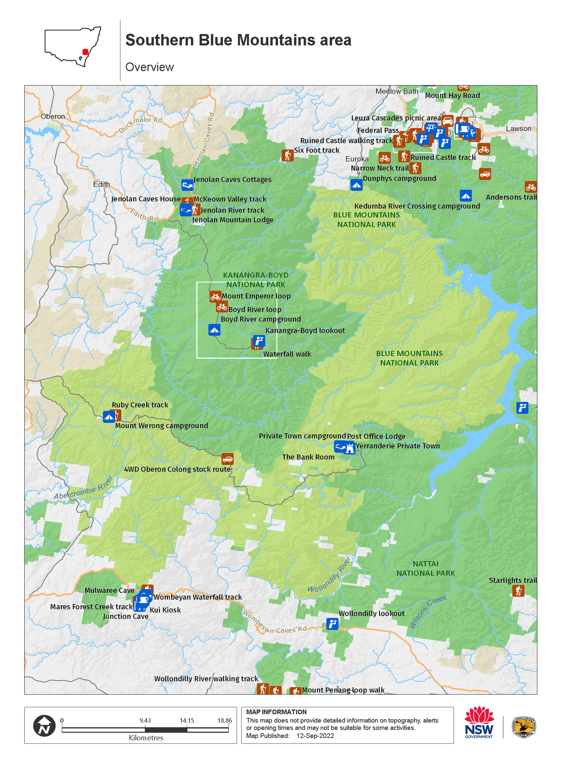
Map legend

Contact
- in Blue Mountains National Park in the Sydney and surrounds and Country NSW regions
Southern Blue Mountains area is always open but some locations may close at times due to poor weather or fire danger.
-
-
Oberon office
02 6336 6200
Contact hours: Monday to Friday, 9am to 4.30pm. - 38 Ross Street, Oberon NSW 2787
-
Email: npws.kanangra@environment.nsw.gov.au
-
Oberon office
-
-
Blue Mountains Heritage Centre and Blackheath office
02 4787 8877
Contact hours: 9am to 4pm daily. Closed Christmas Day. - 270 Govetts Leap Road, Blackheath NSW 2785
-
Email: bluemountains.heritagecentre@environment.nsw.gov.au
-
Blue Mountains Heritage Centre and Blackheath office
Visitor info
All the practical information you need to know about the Southern Blue Mountains area.
Maps and downloads
Nearby towns
Oberon (34 km)
If the famous Jenolan Caves are on your travel itinerary Oberon in the Blue Mountains is the perfect spot from which to plan your caving adventure. There are a number of ways visitors can tour the caves.
Taralga (65 km)
Many of Taralga's existing buildings date from the 1860s to the 1890s, and most of them consist of stone from local volcanic supplies. This has resulted in an architectural style unique to Taralga that is somewhere between Georgian and Victorian, giving the town a unique and picturesque aesthetic.
Goulburn (111 km)
Named after Henry Goulburn - the British Secretary of State for the Colonies, Goulburn developed into a major centre for wool, and in 1863, it became Australia's first inland city. Today, the town is a rich hub of history, discovery and natural beauty.
Learn more
Southern Blue Mountains area is a special place. Here are just some of the reasons why:
Plants and animals protected in this park
Animals
-

Bare-nosed wombat (Vombatus ursinus)
A large, squat marsupial, the Australian bare-nosed wombat is a burrowing mammal found in coastal forests and mountain ranges across NSW and Victoria. The only other remaining species of wombat in NSW, the endangered southern hairy-nosed wombat, was considered extinct until relatively recently.
-

Eastern bentwing-bat (Miniopterus schreibersii oceanensis)
Eastern bentwing-bats congregate in caves across the east and north-west coasts of Australia, in colonies of up to 150,000. These small Australian animals weigh around 13-17g and can reach speeds of up to 50km per hour. Eastern bentwing-bats use both sight and echolocation to catch small insects mid-air.
-

Lace monitor (Varanus varius)
One of Australia’s largest lizards, the carnivorous tree-dwelling lace monitor, or tree goanna, can grow to 2m in length and is found in forests and coastal tablelands across eastern Australia. These Australian animals are typically dark blue in colour with whitish spots or blotches.
-

Short-beaked echidna (Tachyglossus aculeatus)
One of only 2 egg-laying mammals in the world, the short-beaked echidna is one of the most widespread of Australian native animals. Covered in spines, or quills, they’re equipped with a keen sense of smell and a tube-like snout which they use to break apart termite mounds in search of ants.
-

Sugar glider (Petaurus breviceps)
The sugar glider is a tree-dwelling Australian native marsupial, found in tall eucalypt forests and woodlands along eastern NSW. The nocturnal sugar glider feeds on insects and birds, and satisfies its sweet tooth with nectar and pollens.
-

Tawny frogmouth (Podargus strigoides)
Found throughout Australia, the tawny frogmouth is often mistaken for an owl due to its wide, powerful beak, large head and nocturnal hunting habits. The ‘oom oom oom’ call of this native bird can be heard echoing throughout a range of habitats including heath, woodlands and urban areas.
-

Superb lyrebird (Menura novaehollandiae)
With a complex mimicking call and an elaborate courtship dance to match, the superb lyrebird is one of the most spectacular Australian animals. A bird watching must-see, the superb lyrebird can be found in rainforests and wet woodlands across eastern NSW and Victoria.
-

Swamp wallaby (Wallabia bicolor)
The swamp wallaby, also known as the black wallaby or black pademelon, lives in the dense understorey of rainforests, woodlands and dry sclerophyll forest along eastern Australia. This unique Australian macropod has a dark black-grey coat with a distinctive light-coloured cheek stripe.
-

Spotted-tailed quoll (Dasyurus maculatus)
The spotted-tailed quoll is the largest remaining carnivorous marsupial on the Australian mainland. It’s protected as a vulnerable species in NSW.
Plants
-

Grass tree (Xanthorrea spp.)
An iconic part of the Australian landscape, the grass tree is widespread across eastern NSW. These Australian native plants have a thick fire-blackened trunk and long spiked leaves. They are found in heath and open forests across eastern NSW. The grass tree grows 1-5m in height and produces striking white-flowered spikes which grow up to 1m long.
-

Old man banksia (Banksia serrata)
Hardy Australian native plants, old man banksias can be found along the coast, and in the dry sclerophyll forests and sandstone mountain ranges of NSW. With roughened bark and gnarled limbs, they produce a distinctive cylindrical yellow-green banksia flower which blossoms from summer to early autumn.
-

Scribbly gum (Eucalyptus haemastoma)
Easily identifiable Australian native plants, scribbly gum trees are found throughout NSW coastal plains and hills in the Sydney region. The most distinctive features of this eucalypt are the ‘scribbles’ made by moth larva as it tunnels between the layers of bark.
Environments in this area
What we're doing
Southern Blue Mountains area has management strategies in place to protect and conserve the values of this park. View the detailed park and fire management documents. Here is just some of the work we’re doing to conserve these values: