Mount Kembla Ring track
Illawarra Escarpment State Conservation Area
Overview
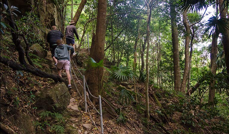
Taking in a significant Aboriginal site, local heritage, stunning scenic rainforest and a notable landmark, the Mount Kembla Ring track offers a taste of everything.
- Distance
- 5.3km loop
- Time suggested
- 2hrs 30min - 3hrs 30min
- Grade
- Grade 4
- Opening times
The track is always open, but it is recommended that the walk only be attempted during daylight hours.
- What to
bring - Hat, sunscreen, drinking water
- Please note
- Take care and watch for motor vehicles while walking on Cordeaux Road.
- Remember to take your binoculars if you want to bird watch.
Mount Kembla is a significant Aboriginal site for the Wodi Wodi people, featuring in many of their creation stories. The impressive natural landmark also acts as a dramatic backdrop for the Ring track, with lush vegetation and a glimpse of local history on a terrific 5km loop.
With access to the scenic Kembla lookout (via the Summit track), there’s much to see, from native birdwatching to spectacular views of the NSW coast. So don’t forget your hiking boots.
The Ring track quickly descends from shaded slopes into cool rainforest. Cycling offers a thrilling alternative on the fire trail. Also, note the closed entrances to two early coal mines – the area is rich with fascinating Illawarra heritage.
Take a virtual tour of Mount Kembla Ring track captured with Google Street View Trekker.
Map
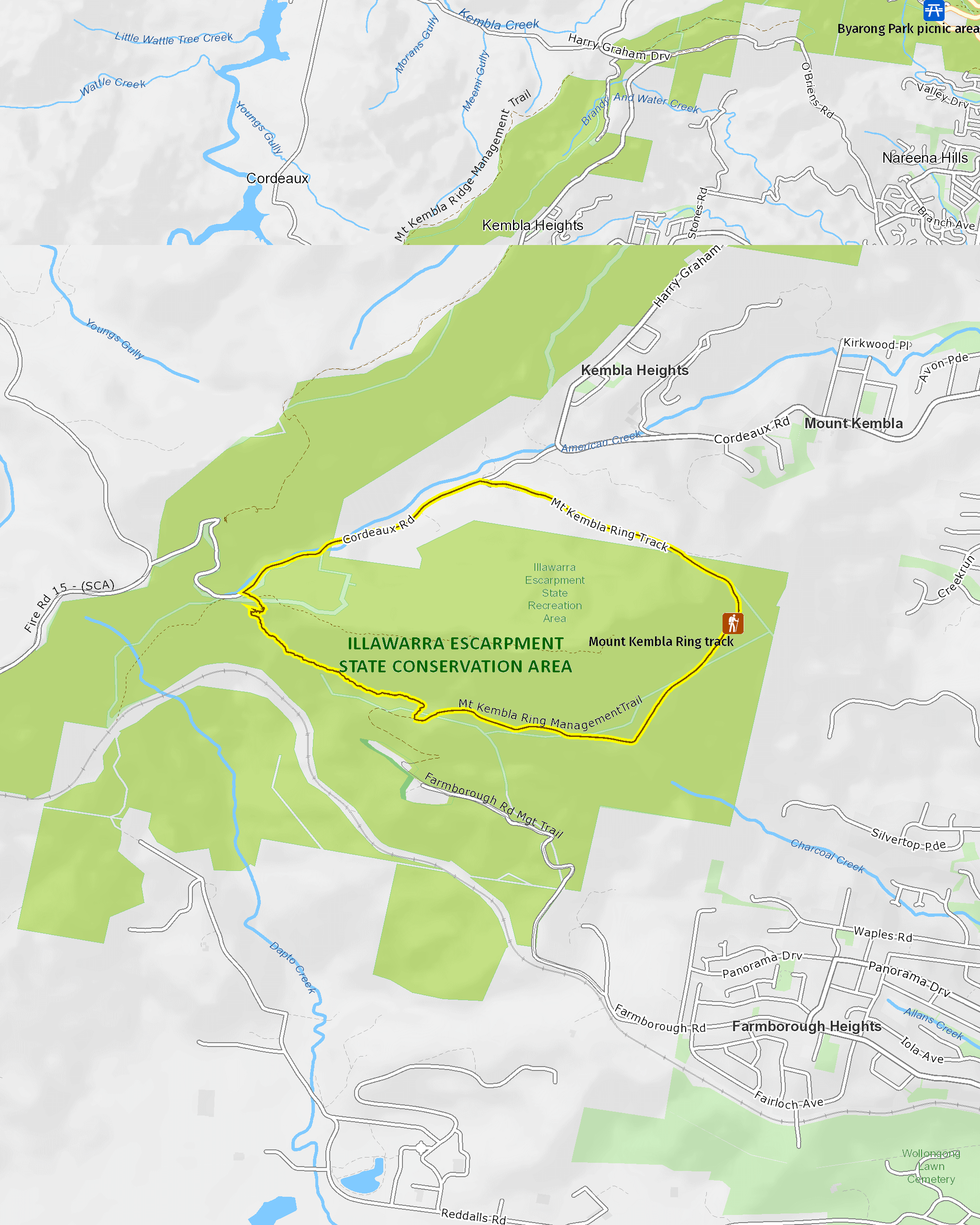
Map legend

Local alerts
For the latest updates on fires, closures and other alerts in this area, see https://www.nationalparks.nsw.gov.au/things-to-do/walking-tracks/mount-kembla-ring-track/local-alerts
General enquiries
- National Parks Contact Centre
- 7am to 7pm daily
- 1300 072 757 (13000 PARKS) for the cost of a local call within Australia excluding mobiles
- parks.info@environment.nsw.gov.au
Park info
- in Illawarra Escarpment State Conservation Area in the South Coast region
Illawarra Escarpment State Conservation Area is always open but may have to close at times due to poor weather or fire danger. However, it is recommended that bushwalking only be undertaken during daylight hours because of the presence of cliff edges and other hazards.
Visitor info
All the practical information you need to know about Mount Kembla Ring track.
Maps and downloads
Learn more
Mount Kembla Ring track is in Illawarra Escarpment State Conservation Area. Here are just some of the reasons why this park is special:
200 million years and counting

The 500-metre-high Illawarra Escarpment provides a dramatic backdrop to the city of Wollongong and spans 200 million years of geological history. The escarpment is so notable, it's currently listed as a 'Scenic Landscape of State-wide Significance' on the Register of the National Trust of Australia (NSW).
- Forest walk to Sublime Point track Combining several hiking tracks, this extended day walk is one of the region’s best, taking in scenic views of the coast and Sydney, with access to nearby forest picnic spots.
- Mount Keira Ring track Encircling Mount Keira, the ring track passes through the varied terrains and forests of the Illawarra Escarpment, starting and finishing in a perfect picnic spot.
- Sublime Point walking track For a challenging walk through rainforest, Sublime Point walking track offers great birdwatching and scenic views across Illawarra Escarpment State Conservation Area.
Going bush

The Illawarra Escarpment contains the most extensive area of rainforest in the Sydney basin and forms a crucial corridor between Royal National Park and the South Coast. The area acts as an important refuge for species that are affected by environmental disturbances such as development and bushfires. There are currently 12 threatened animal species in the area. You might even spot a lyrebird, the wildlife emblem of the National Parks and Wildlife Service.
- Byarong Park picnic area Easily accessible and featuring all the facilities needed to enjoy a barbecue, the popular Byarong Park picnic area also offers walking track access and birdwatching.
- Forest walk to Sublime Point track Combining several hiking tracks, this extended day walk is one of the region’s best, taking in scenic views of the coast and Sydney, with access to nearby forest picnic spots.
How it all began

The Illawarra Escarpment lands were occupied by the Wodi Wodi Aboriginal people for 20,000 years. As such, they are a source of cultural legends and of continuing spiritual significance: Mount Kembla and Mount Keira, for example, feature in a number of creation stories. The conversation area also contains traditional routes of travel between the coastal plain and the plateau.
- Mount Kembla Ring track Taking in a significant Aboriginal site, local heritage, stunning scenic rainforest and a notable landmark, the Mount Kembla Ring track offers a taste of everything.
Our colonial past

The Illawarra Escarpment area is full of important local heritage, including colonial roads like the ones constructed by Surveyor-General Thomas Mitchell around 1834. Some were even built by convicts. Keep your eyes open for buildings, portals, rail tracks and other features from former farming and coal mining.
- Mount Keira Ring track Encircling Mount Keira, the ring track passes through the varied terrains and forests of the Illawarra Escarpment, starting and finishing in a perfect picnic spot.
Weekend city escape

Illawarra Escarpment State Conservation Area's convenient proximity to the city and public transport options means it has become an important venue for sports and recreation - on weekends it buzzes with hikers, picnickers, and cyclists.
- Byarong Park picnic area Easily accessible and featuring all the facilities needed to enjoy a barbecue, the popular Byarong Park picnic area also offers walking track access and birdwatching.
- Robertson lookout The most scenic views of Mount Keira can be found at Robertson’s lookout, and tables make this a terrific picnic spot as well.
Plants and animals protected in this park
Animals
-

Superb lyrebird (Menura novaehollandiae)
With a complex mimicking call and an elaborate courtship dance to match, the superb lyrebird is one of the most spectacular Australian animals. A bird watching must-see, the superb lyrebird can be found in rainforests and wet woodlands across eastern NSW and Victoria.
-

Peron's tree frog (Litoria peroni)
Peron’s tree frog is found right across NSW. These tree-climbing and ground-dwelling Australian animals can quickly change colour, ranging from pale green-grey by day, to a reddish brown with emerald green flecks at night. The male frog has a drill-like call, which has been described as a 'maniacal cackle’.
-

Grey-headed flying-fox (Pteropus poliocephalus)
The grey-headed flying fox is Australia's largest native bat, with a wingspan up to 1m. This threatened species travels up and down south-eastern Australia and plays a vital role in pollinating plants and spreading seeds in our native forests.