Overview
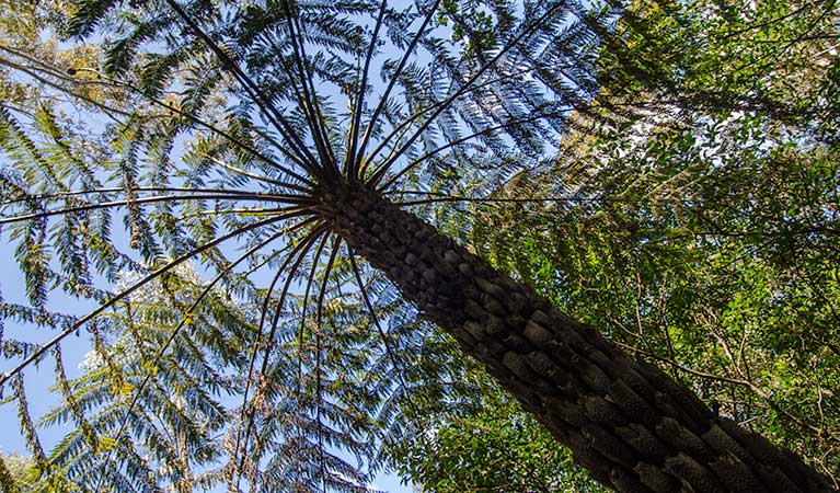
Encircling Mount Keira, the ring track passes through the varied terrains and forests of the Illawarra Escarpment, starting and finishing in a perfect picnic spot.
- Distance
- 5.5km loop
- Time suggested
- 3hrs 30min - 4hrs 30min
- Grade
- Grade 4
- Opening times
The track-head at Byarong Park is open from sunrise to sunset.
- Please note
- For your own safety, please stay on the track at all times.
- Do not wander off the track or attempt to ride, climb or walk through the escarpment because of serious risk of injury from rock fall in these areas.
- Take great care crossing Mount Keira Road, it can be busy at times.
- When walking in a clockwise direction, at the junction with Mount Pleasant trail turn right to stay on Mount Keira Ring track and return to Byarong Park.
Circling Mount Keira in an engaging loop, the ring track is a terrific setting for a casual hike or an energetic run. Expect to encounter a lush parade of forests and terrain, from cool sub-tropical bush to lofty red cedars and rocky outcrops. Catbirds call in the rainforest as you trace the old route of an early colonial road.
You’ll find the track-head by following the trail from the Byarong car park to the Girl Guide Camp entrance road. Cross the road, rejoining the trail on the other side. The ring track is just a short distance away.
If you want to make a day of it, pack a picnic. Byarong Park picnic area is a terrific spot to settle down for a relaxing barbecue or an afternoon ball game.
Take a virtual tour of Mount Keira Ring track captured with Google Street View Trekker.
Map
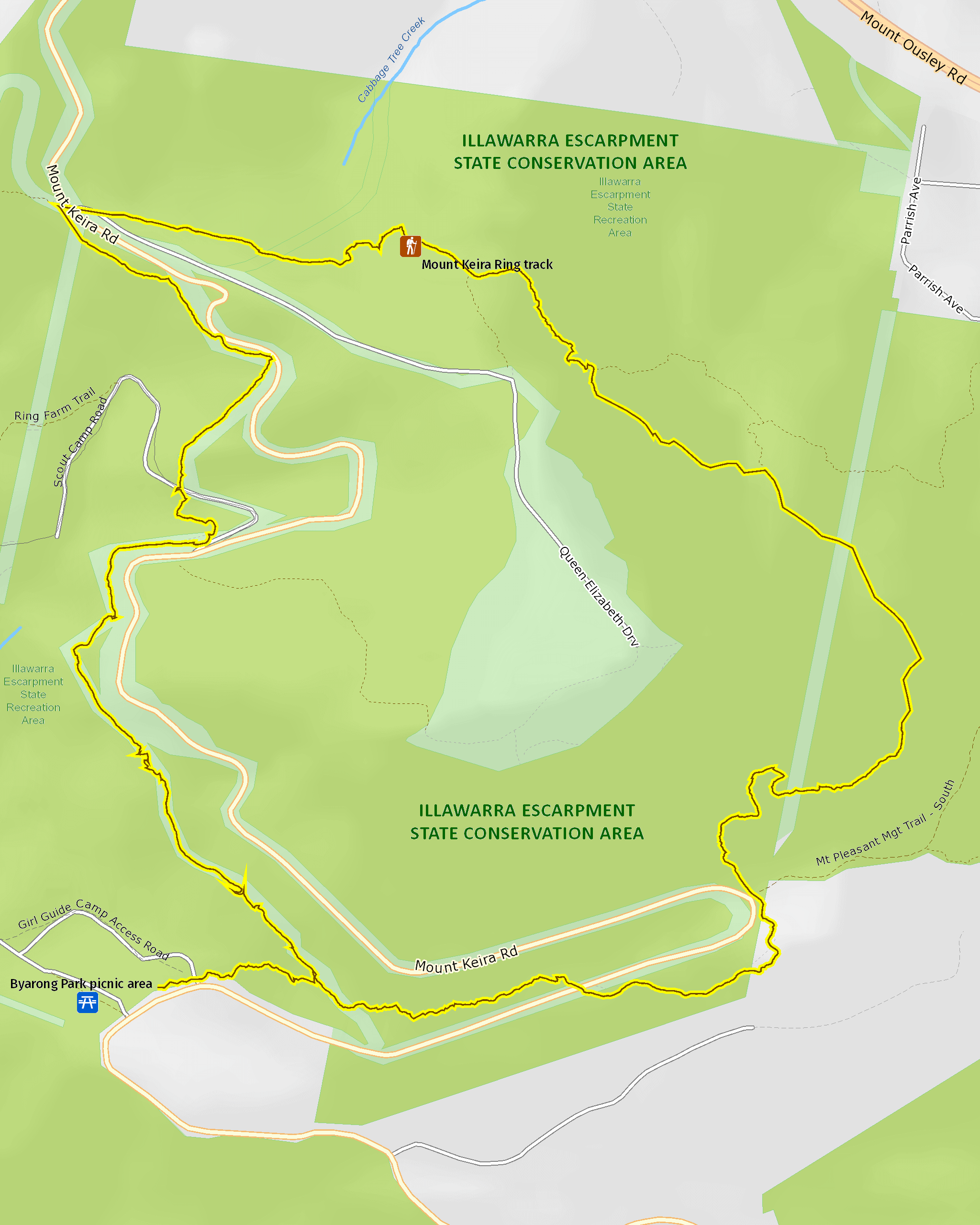
Map legend

Local alerts
For the latest updates on fires, closures and other alerts in this area, see https://www.nationalparks.nsw.gov.au/things-to-do/walking-tracks/mount-keira-ring-track/local-alerts
General enquiries
- National Parks Contact Centre
- 7am to 7pm daily
- 1300 072 757 (13000 PARKS) for the cost of a local call within Australia excluding mobiles
- parks.info@environment.nsw.gov.au
Park info
- in Illawarra Escarpment State Conservation Area in the South Coast region
Illawarra Escarpment State Conservation Area is always open but may have to close at times due to poor weather or fire danger. However, it is recommended that bushwalking only be undertaken during daylight hours because of the presence of cliff edges and other hazards.
Visitor info
All the practical information you need to know about Mount Keira Ring track.
Track grading
Features of this track
Distance
5.5km loop
Time
3hrs 30min - 4hrs 30min
Quality of markings
Clearly sign posted
Experience required
Experienced bushwalkers
Gradient
Short steep hills
Steps
Many steps
Quality of path
Formed track, some obstacles
Getting there and parking
Byarong Park picnic area, where the track begins, is in the Mount Keira precinct of Illawarra Escarpment State Conservation Area. To get there:
- Heading south on the Southern Freeway from Waterfall towards Wollongong, exit at Figtree.
- Turn left onto the Princes Highway
- After 0.5km, turn left again onto Mount Keira Road. It is 3km to Byarong Park.
Parking
Parking is available at Byarong Park. It can be a busy place on the weekend, so parking might be limited.
Best times to visit
There are lots of great things waiting for you in Illawarra Escarpment State Conservation Area. Here are some of the highlights.
Spring
Enjoy a native wildflower display on the Forest walk.
Summer
Cool your heels on the Mount Keira ring track, which threads through refreshing rainforest.
Winter
Take advantage of the escarpment elevation for a spot of whale watching north of Mount Keira, or from one of the several lookouts.
Weather, temperature and rainfall
Summer temperature
Average
16.5°C and 25.6°C
Highest recorded
42.3°C
Winter temperature
Average
8.3°C and 18.3°C
Lowest recorded
-0.5°C
Rainfall
Wettest month
April
Driest month
August
The area’s highest recorded rainfall in one day
316mm
Facilities
Drinking water isn't available in this area, so you'll need to bring your own supply.
Maps and downloads
Prohibited
Pets
Pets and domestic animals (other than certified assistance animals) are not permitted. Find out which regional parks allow dog walking and see the pets in parks policy for more information.
Smoking
NSW national parks are no smoking areas.
Learn more
Mount Keira Ring track is in Illawarra Escarpment State Conservation Area. Here are just some of the reasons why this park is special:
200 million years and counting

The 500-metre-high Illawarra Escarpment provides a dramatic backdrop to the city of Wollongong and spans 200 million years of geological history. The escarpment is so notable, it's currently listed as a 'Scenic Landscape of State-wide Significance' on the Register of the National Trust of Australia (NSW).
- Forest walk to Sublime Point track Combining several hiking tracks, this extended day walk is one of the region’s best, taking in scenic views of the coast and Sydney, with access to nearby forest picnic spots.
- Mount Keira Ring track Encircling Mount Keira, the ring track passes through the varied terrains and forests of the Illawarra Escarpment, starting and finishing in a perfect picnic spot.
- Sublime Point walking track For a challenging walk through rainforest, Sublime Point walking track offers great birdwatching and scenic views across Illawarra Escarpment State Conservation Area.
Going bush

The Illawarra Escarpment contains the most extensive area of rainforest in the Sydney basin and forms a crucial corridor between Royal National Park and the South Coast. The area acts as an important refuge for species that are affected by environmental disturbances such as development and bushfires. There are currently 12 threatened animal species in the area. You might even spot a lyrebird, the wildlife emblem of the National Parks and Wildlife Service.
- Byarong Park picnic area Easily accessible and featuring all the facilities needed to enjoy a barbecue, the popular Byarong Park picnic area also offers walking track access and birdwatching.
- Forest walk to Sublime Point track Combining several hiking tracks, this extended day walk is one of the region’s best, taking in scenic views of the coast and Sydney, with access to nearby forest picnic spots.
How it all began

The Illawarra Escarpment lands were occupied by the Wodi Wodi Aboriginal people for 20,000 years. As such, they are a source of cultural legends and of continuing spiritual significance: Mount Kembla and Mount Keira, for example, feature in a number of creation stories. The conversation area also contains traditional routes of travel between the coastal plain and the plateau.
- Mount Kembla Ring track Taking in a significant Aboriginal site, local heritage, stunning scenic rainforest and a notable landmark, the Mount Kembla Ring track offers a taste of everything.
Our colonial past

The Illawarra Escarpment area is full of important local heritage, including colonial roads like the ones constructed by Surveyor-General Thomas Mitchell around 1834. Some were even built by convicts. Keep your eyes open for buildings, portals, rail tracks and other features from former farming and coal mining.
- Mount Keira Ring track Encircling Mount Keira, the ring track passes through the varied terrains and forests of the Illawarra Escarpment, starting and finishing in a perfect picnic spot.
Weekend city escape

Illawarra Escarpment State Conservation Area's convenient proximity to the city and public transport options means it has become an important venue for sports and recreation - on weekends it buzzes with hikers, picnickers, and cyclists.
- Byarong Park picnic area Easily accessible and featuring all the facilities needed to enjoy a barbecue, the popular Byarong Park picnic area also offers walking track access and birdwatching.
- Illawarra Escarpment mountain bike volunteers The Illawarra mountain bike network is a popular mountain bike network in Illawarra Escarpment State Conservation Area, near Wollongong. If cleaning up the garden is one of your strengths, volunteer today to help us maintain the trails.
- Kembla mountain bike trails Kembla mountain bike trails offer adventures for riders of all ages and skill levels. Located near Wollongong, these special trails have been carefully crafted to get your legs pumping while protecting the environment. Come and ride lightly through Illawarra Escarpment State Conservation Area on Dharawal Country.
- Robertson lookout The most scenic views of Mount Keira can be found at Robertson’s lookout, and tables make this a terrific picnic spot as well.
Plants and animals protected in this park
Animals
-

Superb lyrebird (Menura novaehollandiae)
With a complex mimicking call and an elaborate courtship dance to match, the superb lyrebird is one of the most spectacular Australian animals. A bird watching must-see, the superb lyrebird can be found in rainforests and wet woodlands across eastern NSW and Victoria.
-

Peron's tree frog (Litoria peroni)
Peron’s tree frog is found right across NSW. These tree-climbing and ground-dwelling Australian animals can quickly change colour, ranging from pale green-grey by day, to a reddish brown with emerald green flecks at night. The male frog has a drill-like call, which has been described as a 'maniacal cackle’.
-

Grey-headed flying-fox (Pteropus poliocephalus)
The grey-headed flying fox is Australia's largest native bat, with a wingspan up to 1m. This threatened species travels up and down south-eastern Australia and plays a vital role in pollinating plants and spreading seeds in our native forests.
General enquiries
- National Parks Contact Centre
- 7am to 7pm daily
- 1300 072 757 (13000 PARKS) for the cost of a local call within Australia excluding mobiles
- parks.info@environment.nsw.gov.au
Operated by
- Wollongong office
- Monday to Friday, 8.30am to 4.30pm.
- 02 4224 4188
- npws.illawarrahighlands@environment.nsw.gov.au
- Unit G Ground Floor, 84 Crown Street, Wollongong NSW 2500
Park info
- in Illawarra Escarpment State Conservation Area in the South Coast region
Illawarra Escarpment State Conservation Area is always open but may have to close at times due to poor weather or fire danger. However, it is recommended that bushwalking only be undertaken during daylight hours because of the presence of cliff edges and other hazards.