Overview
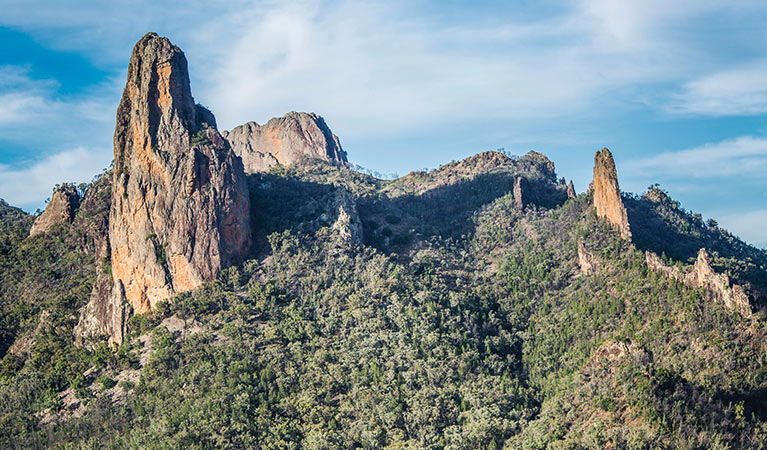
Goulds Circuit walking track is a wonderful way for day trippers and overnight campers to capture sweeping views of Warrumbungle National Park’s volcanic features.
- Where
- Warrumbungle National Park in Country NSW
- Accessibility
- No wheelchair access
- Distance
- 8km loop
- Time suggested
- 3hrs
- Grade
- Grade 3
- Entry fees
- Park entry fees apply
- What to
bring - Drinking water, sturdy shoes, suitable clothing, first aid kit, hat, sunscreen, raincoat, snacks
- Please note
- The Warrumbungle National Park Visitor Centre is a great place to pick up maps and get advice about walking tracks.
- Take care if you make the near-vertical rock scramble to the summit of Macha Tor. Macha Tor is only recommended for experienced hikers and climbers.
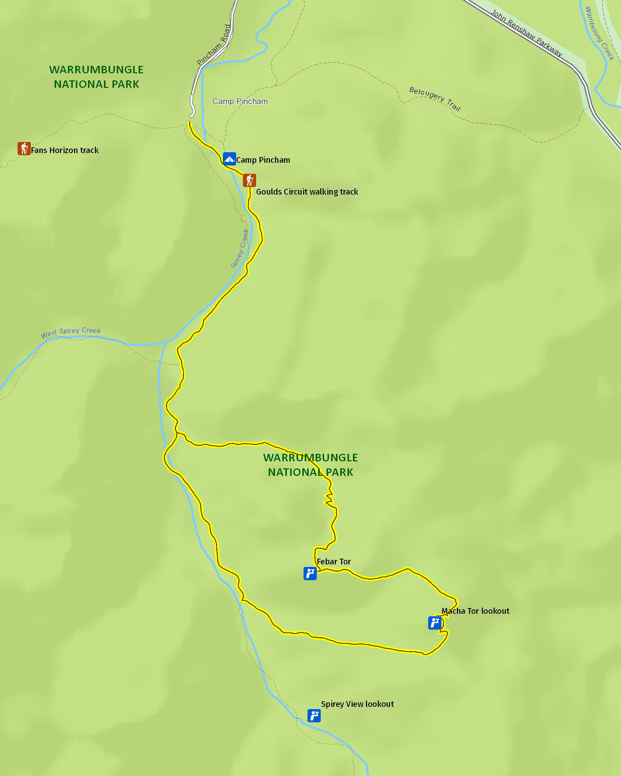
Start at Pincham carpark and follow Spirey Creek as you immerse yourself in the peaceful sights and sounds of dry woodland. Keep an eye out for colourful king parrots and crimson rosellas flying between the trees.
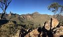
After about 1.8km, take the Goulds Circuit track turnoff. The trail is rougher and hillier from here, but soon rewards you with fabulous views. You may see red-necked wallabies and swamp wallabies along this track, especially during the early morning and late afternoon.
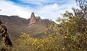
Scramble up the Febar Tor rocky outcrop for sweeping views of Belougery Spire, the Breadknife and Bluff Mountain. Save some energy to tackle the second viewpoint, Macha Tor. This near-vertical scramble offers some of the Grand High Tops’ best views. It’s the perfect spot to enjoy a picnic lunch as you gaze out over the Breadknife and Crater Bluff.
When you’re ready to come down, continue along the track to link back up with the main trail. From here it’s just 2.8km back to the carpark.
Keen to pack in another Warrumbungles walk that’s short on distance but long on views? Try Fans Horizon walking track. Fit, experienced hikers with more time on their hands will enjoy the iconic Breadknife and Grand High Tops walk, with optional Bluff Mountain summit.
Along this track
-
Macha Tor
Macha Tor is in Warrumbungle National Park, on Goulds Circuit walking track. For experienced hikers and climbers only, the climb up this steep rocky outcrop offers panoramic views of the Grand High Tops.
-
Febar Tor
Febar Tor is in Warrumbungle National Park, along Goulds Circuit walking track. Scramble up this rocky outcrop for panoramic views of Grand High Tops spires, peaks and outcrops.
Map
Map legend

Local alerts
For the latest updates on fires, closures and other alerts in this area, see https://www.nationalparks.nsw.gov.au/things-to-do/walking-tracks/goulds-circuit-walking-track/local-alerts
General enquiries
- National Parks Contact Centre
- 7am to 7pm daily
- 1300 072 757 (13000 PARKS) for the cost of a local call within Australia excluding mobiles
- parks.info@environment.nsw.gov.au
Park info
- in Warrumbungle National Park in the Country NSW region
Warrumbungle National Park is always open but may have to close at times due to poor weather or fire danger.
-
Park entry fees:
$8 per vehicle per day.
Buy annual pass.
Visitor info
All the practical information you need to know about Goulds Circuit walking track.
Track grading
Features of this track
Distance
8km loop
Time
3hrs
Quality of markings
Clearly sign posted
Experience required
Some bushwalking experience recommended
Gradient
Short steep hills
Steps
Many steps
Quality of path
Formed track, some obstacles
Getting there and parking
Goulds Circuit is in the southern area of Warrumbungle National Park. To get there from Coonabarabran:
- Follow John Renshaw Drive into Warrumbungle National Park
- Turn left into Pincham Road around 100m past the visitor centre turnoff
- Continue to Pincham carpark
Road quality
- Sealed roads
Vehicle access
- 2WD vehicles
Weather restrictions
- All weather
Parking
Parking is available at Pincham carpark.
Facilities
There are no bins so you’ll need to take all rubbish with you.
Toilets
Toilets are located at Pincham carpark, at the start of this walk.
- Non-flush toilets
Carpark
Maps and downloads
Accessibility
Disability access level - no wheelchair access
Prohibited
Camp fires and solid fuel burners
Camping
Cycling
Drones
Flying a drone for recreational purposes is prohibited in this area. Drones may affect public enjoyment, safety and privacy, interfere with park operations, or pose a threat to wildlife. See the Drones in Parks policy.
This area may be a declared Drone Exclusion Zone, or may be subject to Civil Aviation Safety Authority (CASA) rules for flying near airports, aerodromes and helicopter landing sites. See CASA's Drone Flyer Rules.
Commercial filming and photography
Commercial filming or photography is prohibited without prior consent. You must apply for permission and contact the local office.
Gathering firewood
Generators
Pets
Pets and domestic animals (other than certified assistance animals) are not permitted. Find out which regional parks allow dog walking and see the pets in parks policy for more information.
Smoking
NSW national parks are no smoking areas.
Visitor centre
-
Warrumbungle Visitor Centre
4261 John Renshaw Parkway, Warrumbungle NSW 2828 - 9am to 4pm daily. Closed Christmas Day.
- 02 6825 4364
Learn more
Goulds Circuit walking track is in Warrumbungle National Park. Here are just some of the reasons why this park is special:
Aboriginal dreamtime

Warrumbungle is a Gamilaraay word meaning crooked mountain, and for many thousands of years it has been a spiritual place for the custodians of this land, the Gamilaraay, the Wiradjuri and the Weilwan. The landscape, plants and animals of the park are a constant reminder of its sacred significance to Aboriginal people today. Take an Aboriginal Discovery guided tour to find out more about the Aboriginal cultural heritage.
- Tara Cave cultural tour Join this guided tour led by a local Aboriginal Discovery ranger. Discover the cultural heritage in the land of the Gamilaraay, Wiradjuri and Wailwan people in Warrumbungle National Park, near Coonabarabran.
- Tara Cave walking track Tara Cave walking track is a gentle 3.4km return bushwalk through Warrumbungle National Park, near Coonabarabran. Learn about local Aboriginal culture and experience remarkable views.
Diversity of wildlife

Warrumbungle National Park has a diversity of landforms and microclimates, and provides a habitat for hundreds of plant and animal species. Wildflowers and unique plants, such as the Warrumbungle star flower, golden cassinia and grey ray flower, flourish there. Over 190 bird species have been recorded in the park, including emus, wedge-tailed eagles and turquoise parrots. If you're lucky, you could also spot koalas, squirrel gliders, lace monitors and Warrumbungle black rock skinks high in the mountains. But for now, Warrumbungle's seriously endangered brush-tailed rock-wallabies have been relocated to a remote feral cat and fox-free area within the park. It's a secure environment where the rock-wallaby population can recover and thrive, free from predators.
- Boots and brushes - guided walk and art tour Tap into your creativity on a 6km guided walk with a Discovery ranger in Warrumbungle National Park. Create your own personal artwork inspired by the iconic mountain landscape at Spirey View lookout.
- Burbie Canyon walking track Burbie Canyon walking track in Warrumbungle National Park offers a gentle 2km stroll through a sandstone gorge, and is particularly popular for birdwatching.
- Tara Cave cultural tour Join this guided tour led by a local Aboriginal Discovery ranger. Discover the cultural heritage in the land of the Gamilaraay, Wiradjuri and Wailwan people in Warrumbungle National Park, near Coonabarabran.
- Walk on the wild side at the Warrumbungles Join an experienced Discovery Ranger and explore the beauty of Warrumbungle National Park. This tour is designed to bring your senses alive as you explore the sights, sounds and smells of this beautiful area.
- Warrumbungle Environmental Education Centre Warrumbungle National Park Environmental Education Centre is operated by the NSW Department of Education. It's dedicated to supporting students and teachers with fieldwork and environmental education.
Landscape and geology

The landscape of Warrumbungle National Park has been shaped by millions of years of volcanic activity and erosion; spend some time looking at Crater Bluff and Belougery Spire and imagine the vents of magma that once erupted to create these formations. Layers of lava and volcanic rock created Mount Exmouth and Mount Woorut just outside the boundary of the park, and Belougery Split Rock and Bluff Mountain are great examples of igneous lava domes. One of the most iconic features in the park, The Breadknife, is a volcanic dyke which stands a massive 90m tall. You can learn more about the park's fascinating geological history, or take a self-guided geology tour, through the NSW GeoTours app.
- Bluff Mountain walking track Bluff Mountain walking track rewards experienced, fit bushwalkers with Warrumbungle National Park’s best views. This very long and challenging steep hike climbs past spectacular rock spires and domes—up to the summit of Bluff Mountain.
- Boots and brushes - guided walk and art tour Tap into your creativity on a 6km guided walk with a Discovery ranger in Warrumbungle National Park. Create your own personal artwork inspired by the iconic mountain landscape at Spirey View lookout.
- Breadknife and Grand High Tops walk Breadknife and Grand High Tops walk in Warrumbungle National Park, regarded as one of the best walks in NSW, offers close up views of the park’s iconic rock formations.
- Burbie Canyon walking track Burbie Canyon walking track in Warrumbungle National Park offers a gentle 2km stroll through a sandstone gorge, and is particularly popular for birdwatching.
- Coonabarabran - Baradine - Warrumbungle drive Explore the spectacular landscapes, historic towns, picnic spots and walks of the Warrumbungles and Pilliga, near Coonabarabran and Baradine, in NSW.
Wish upon a star

Warrumbungle National Park is Australia’s first Dark Sky Park. Nearby Coonabarabran is known as the 'Astronomy Capital of Australia'. Stargaze from your campsite, or if you want to see right up to the heavens, visit a local observatory. The dramatic mix of volcanic spires and domes, plateaus, forested ridges and tall volcanic dykes are bound to make even the youngest of photographers look good, so whatever you do ‐ don't forget your camera.
- Canyon picnic area Canyon picnic area is a fully accessible, family friendly picnic area in Warrumbungle National Park. Not far from the visitor centre, it features barbecues and tables.
- Warrumbungle Visitor Centre Visitor information is available at the Warrumbungle Visitor Centre, which is now back in its original location. Get great suggestions and tips for walking and camping in Warrumbungle National Park.
- Whitegum lookout Whitegum lookout in Warrumbungle National Park features spectacular views of the landscape and picnic tables. It is wheelchair accessible and an easy walk for children.
Plants and animals protected in this park
Animals
-

Wedge-tailed eagle (Aquila audax)
With a wingspan of up to 2.5m, the wedge-tailed eagle is Australia’s largest bird of prey. These Australian animals are found in woodlands across NSW, and have the ability to soar to heights of over 2km. If you’re bird watching, look out for the distinctive diamond-shaped tail of the eagle.
-

Superb fairy wren (Malurus cyaneus)
The striking blue and black plumage of the adult male superb fairy wren makes for colourful bird watching across south-eastern Australia. The sociable superb fairy wrens, or blue wrens, are Australian birds living in groups consisting of a dominant male, mouse-brown female ‘jenny wrens’ and several tawny-brown juveniles.
-

Southern boobook (Ninox novaeseelandiae)
The southern boobook, also known as the mopoke, is the smallest and most common native owl in Australia. With a musical 'boo-book' call that echoes through forests and woodlands, the southern boobook is a great one to look out for while bird watching.
-

Tawny frogmouth (Podargus strigoides)
Found throughout Australia, the tawny frogmouth is often mistaken for an owl due to its wide, powerful beak, large head and nocturnal hunting habits. The ‘oom oom oom’ call of this native bird can be heard echoing throughout a range of habitats including heath, woodlands and urban areas.
-

Kookaburra (Dacelo novaeguineae)
Of the 2 species of kookaburra found in Australia, the laughing kookaburra is the best-known and the largest of the native kingfishers. With its distinctive riotous call, the laughing kookaburra is commonly heard in open woodlands and forests throughout NSW national parks, making these ideal spots for bird watching.
Environments in this park
General enquiries
- National Parks Contact Centre
- 7am to 7pm daily
- 1300 072 757 (13000 PARKS) for the cost of a local call within Australia excluding mobiles
- parks.info@environment.nsw.gov.au
Operated by
- Coonabarabran office
- Monday to Friday, 8.30am to 4.30pm.
- 02 6842 1311
- npws.cra@environment.nsw.gov.au
- 30 Timor Street, Coonabarabran NSW 2357
Park info
- in Warrumbungle National Park in the Country NSW region
Warrumbungle National Park is always open but may have to close at times due to poor weather or fire danger.
-
Park entry fees:
$8 per vehicle per day.
Buy annual pass
What's nearby:
Things to do (29)
- Aboriginal culture (2)
- Adventure sports (1)
- Birdwatching and wildlife encounters (9)
- Educational activities (1)
- Historic heritage (1)
- Picnics and barbecues (2)
- Road trips and car/bus tours (2)
- Sightseeing (17)
- Swimming (1)
- Visitor centres (1)
- Walking (20)
- Wildflowers (seasonal) (10)