Overview
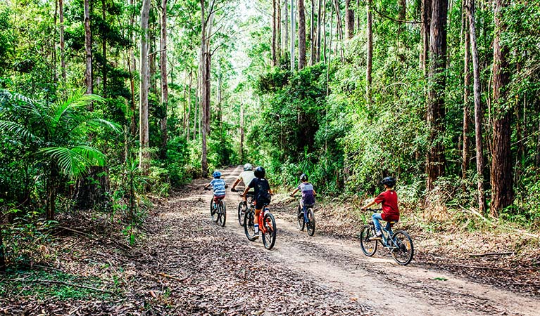
Choose your own adventure on Muurlay Baamgala cycle trails in Bongil Bongil National Park near Coffs Harbour. There are over 80km of relatively flat trails to explore in a beautiful forest setting – great for kids and all levels of riders.
- Where
- Bongil Bongil National Park in North Coast
- Accessibility
- No wheelchair access
- Distance
- 80km of trails
- Time suggested
- 1.5-3 hr
- Grade
- Medium. Each trail on this network has a different length and time suggested. Most trails are reasonably flat and open, suited for gentle forest riding.
- What to
bring - Drinking water, sturdy shoes, suitable clothing, bike repair kit, first aid kit, hat, sunscreen, snacks
- Please note
- These cycling trails are shared with other visitors, so keep an eye out for walkers and vehicles.
- Cooler autumn and winter months are best for long rides
- Advanced riders looking for a challenge can find technical single-track trails in nearby Pine Creek State Forest.
- Mountain bike riding is not permitted on walking tracks in the park
Muurlay Baamgala means ‘track at Bongil Bongil’ in the Gumbaynggirr language. Escape the bitumen and practise your mountain biking skills along sun dappled tracks. This 80km network of fire trails is a great introduction to mountain biking. The trails are reasonably flat with good natural-earth surfaces, surrounded by eucalypt forests with a lush understorey of palms and ferns.
A good place to start is at Sid Burke picnic area off Pine Creek Way. There’s parking, toilets and a large bike map to help plan your adventure. From there you can choose from 3 main loops – Bawarr loop (8.5km), Baranyjin loop (7km) and Galnyam loop (12.5km) – or create your own route.
The eucalypt forests of Bongil Bongil National Park are home to one of NSW’s largest koala populations and more than 165 species of birds, including the glossy black cockatoo and little lorikeet.
After your ride, enjoy a picnic lunch back at Sid Burke picnic area or take a short drive to Bongil picnic area to cook up a barbecue feast. Nearby Bonville Creek is a peaceful coastal estuary, perfect for kayaking and bird watching. If you want to make a weekend of it, Tuckers Rocks Cottage is a beautiful self-contained beach house.
Map
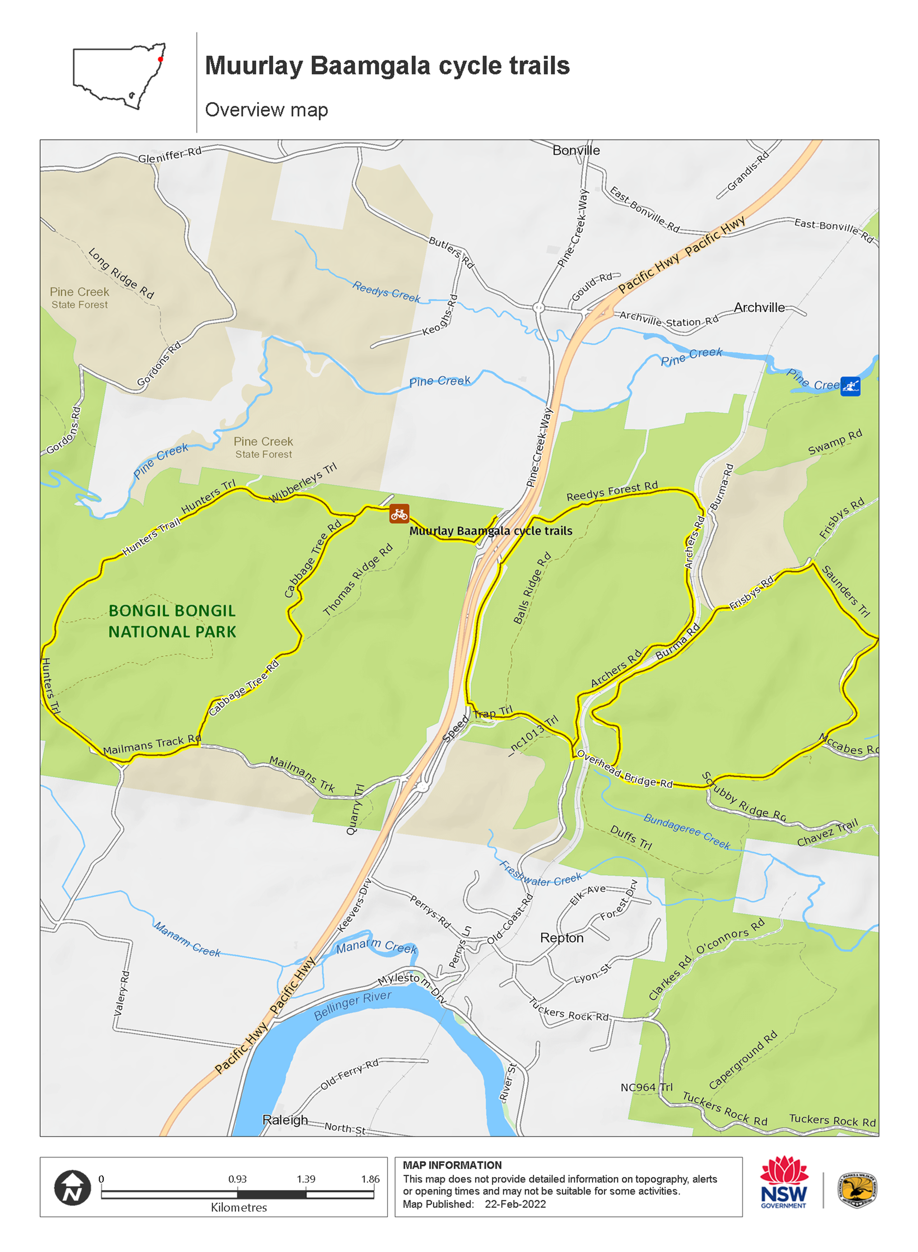
Map legend

Local alerts
For the latest updates on fires, closures and other alerts in this area, see https://www.nationalparks.nsw.gov.au/things-to-do/cycling-trails/muurlay-baamgala-cycle-trails/local-alerts
General enquiries
- National Parks Contact Centre
- 7am to 7pm daily
- 1300 072 757 (13000 PARKS) for the cost of a local call within Australia excluding mobiles
- parks.info@environment.nsw.gov.au
Park info
- in Bongil Bongil National Park in the North Coast region
Bongil Bongil National Park is always open but may have to close at times due to poor weather or fire danger.
Visitor info
All the practical information you need to know about Muurlay Baamgala cycle trails.
Getting there and parking
Muurlay Baamgala cycle trails are in the central area of Bongil Bongil National Park. To get there:
From Coffs Harbour:
- Head south on the Pacific Highway
- Take the Archville Station Road exit
- Turn right at the roundabout at the top of the exit ramp onto Archville Station Road
- Cross over the highway, continue straight ahead at the 2nd roundabout
- Turn left at the 3rd roundabout onto Pine Creek Way
- Cross the Pine Creek bridge and look for the Sid Burke picnic area on your right.
From the south:
- Head north on the Pacific Highway
- Take the Myleston/Repton exit and turn right at the roundabout onto Mailmans Track Road
- At the 2nd roundabout turn left onto Pine Creek Way
- After passing under the highway, look for the Sid Burke picnic area on your left.
Road quality
- Mixture of sealed and unsealed roads
Vehicle access
- Most roads require 4WD vehicle
Weather restrictions
- All weather
Parking
Parking is available at Sid Burke picnic area, off Pine Creek Way.
Facilities
- Toilets, a carpark and picnic tables are located at Sid Burke picnic area, where you can start your ride.
- You’ll also find barbecues and toilets at Bongil picnic area, about 11mins drive or 30mins cycle away.
Toilets
- Non-flush toilets
Picnic tables
Carpark
Maps and downloads
Accessibility
Disability access level - no wheelchair access
Permitted
Cycling
Mountain bike riding is not permitted on walking tracks in the park.
Learn more
Muurlay Baamgala cycle trails is in Bongil Bongil National Park. Here are just some of the reasons why this park is special:
A place where one stays a long time

Bongil Bongil National Park is the traditional land of the Gumbaynggir people, whose ancestral lands extend from Grafton in the north to the Nambucca river in the south, and from the coast west to the headwaters of the Nymboida river. The park provided abundant seafood and bushtucker, and was a site for gatherings and sacred ceremonies.
- Bush tucker Bush tucker is a Stage 4 (Years 7-8) school excursion to Bongil Bongil National Park, which focuses on Geography. Join our Aboriginal Discovery rangers for an easy stroll along the forested banks of Bonville Creek, to investigate the rich diversity of plants and animals in the park.
- Bush tucker Bush tucker in Bongil Bongil National Park is a school excursion for Stage 2 (Years 3-4) students with a focus on Geography and History. Join our Aboriginal Discovery rangers for an easy stroll along the forested banks of Bonville Creek, to investigate the rich diversity of plants and animals in the park.
- Bush tucker in Bongil Bongil National Park Share the bush secrets of the traditional Gumbaynggirr People in Bush tucker – a Stage 3 (Years 5-6) excursion in Bongil Bongil National Park. Aboriginal guides will reveal their special connection to Country and their secrets for health, wellness and survival.
Beaches and waterways

The waterways within Bongil Bongil National Park carry water across the coastal plains from the steep foothills to the west, providing a home for many types of birds, animals and reptiles. For visitors, the waterways and beaches in Bongil Bongil National Park offer a range of water activities, including excellent fishing and kayaking. Try your luck on the Bonville river for flathead and whiting.
Birdwatcher's haven

In addition to being home to one of NSW's largest koala populations, Bongil Bongil National Park also boasts more than 165 species of birds. The park provides breeding, roosting and feeding habitats for a number of migratory birds like the little tern and the pied oystercatcher. The Bundageree Rainforest walk is the best place to see the birds of the rainforest, like the dramatically beautiful wompoo fruit dove and the colourful rose-crowned fruit dove that makes a loud and explosive "hookco" sound.
- Pine Creek paddle route Adventurous canoeists, kayakers, and stand-up paddle boarders will enjoy this downstream route along pristine Pine Creek, a wildlife haven in Bongil Bongil National Park, near Coffs Harbour.
Plants and animals protected in this park
Animals
-

Koala (Phascolarctos cinereus)
One of the most renowned Australian animals, the tree-dwelling marsupial koala can be found in gum tree forests and woodlands across eastern NSW, Victoria and Queensland, as well as in isolated regions in South Australia. With a vice-like grip, this perhaps most iconic but endangered Australian animal lives in tall eucalypts within a home range of several hectares.
-

Grey-headed flying-fox (Pteropus poliocephalus)
The grey-headed flying fox is Australia's largest native bat, with a wingspan up to 1m. This threatened species travels up and down south-eastern Australia and plays a vital role in pollinating plants and spreading seeds in our native forests.
-

Lace monitor (Varanus varius)
One of Australia’s largest lizards, the carnivorous tree-dwelling lace monitor, or tree goanna, can grow to 2m in length and is found in forests and coastal tablelands across eastern Australia. These Australian animals are typically dark blue in colour with whitish spots or blotches.
Plants
-

Grey mangrove (Avicennia marina)
Grey mangrove is the most common and widespread mangrove found within intertidal zones across Australia, and throughout the world. Growing to a height of 3-10m, they thrive best in estuaries with a mix of fresh and salt water. They excrete excess salt through their long thick leaves, and absorb oxygen through their aerial root system.
-

Blueberry ash (Elaeocarpus reticulatus)
The blueberry ash is a rainforest shrub which produces blue olive-shaped berries and spectacular bell-shaped flowers, which often appear on the plant together. It is a tall slender shrub or small tree found in rainforest, tall eucalypt forest and coastal bushland in eastern NSW, south-east Queensland and Victoria.