Overview
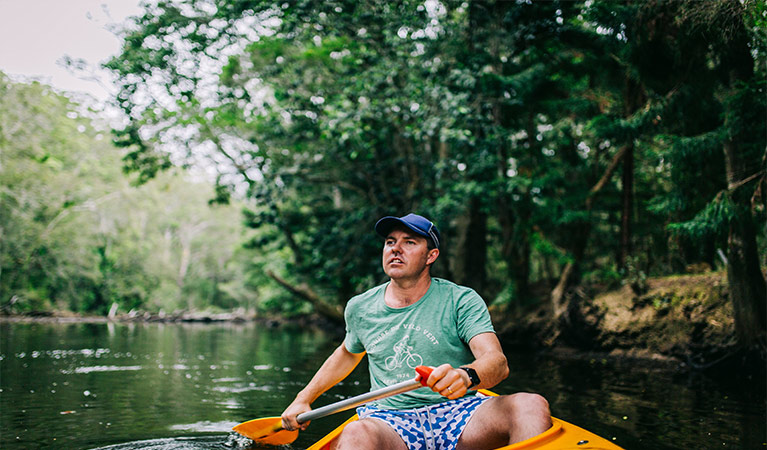
Adventurous canoeists, kayakers, and stand-up paddle boarders will enjoy this downstream route along pristine Pine Creek, a wildlife haven in Bongil Bongil National Park, near Coffs Harbour.
- Where
- Bongil Bongil National Park in North Coast
- Accessibility
- No wheelchair access
- Distance
- 10km one-way
- Time suggested
- 3-4 hr
- Grade
- Medium. Recommended for fit, experienced, self-reliant paddlers.
- What to
bring - Hat, sunscreen, snacks, drinking water, suitable clothing, first aid kit, personal locator beacon
- Please note
- This is a challenging route recommended for experienced, self-reliant paddlers.
- It’s best to paddle at high tide on the outgoing tide, to avoid obstacles like fallen tree branches.
- Depending on water levels, you may need to carry your canoe over obstacles like tree branches at the start of this route.
- You’ll need to arrange a pickup or car shuffle if you plan to paddle one-way.
Canoe, kayak or stand up paddle peaceful Pine Creek in Bongil Bongil National Park. Launch at high tide from the riverbank at the end of Burma Road (4WD access only), and immerse yourself in nature as you glide downstream to meet Bonville Creek, at Sawtell.
This important coastal estuary is a haven for rare plants and animals. Drift through swampy casuarina and paperbark forest, including hoop pines which give the creek its name, adorned with staghorn and elkhorn ferns. From March to May, keep an eye out for endangered black grass-dart butterflies which feed on another endangered species, Floyd's grass.
As you paddle downstream past swamp oak and tall riverbank eucalypt forest, look for sleepy koalas nestled in the branches of tallowwoods. Before long, you'll find yourself among pockets of salt marsh, home to waterbirds and waders.
Your Pine Creek paddle ends at the Bonville Creek boat ramp, off Lyons Road at Sawtell. You’ll need to organise a pickup or car shuffle. If you still have energy, you can paddle upstream along Bonville Creek to Bongil picnic area, where you can enjoy a picnic, fishing, or a more family-friendly paddle along Bonville Creek.
Map
Map legend

Local alerts
For the latest updates on fires, closures and other alerts in this area, see https://www.nationalparks.nsw.gov.au/things-to-do/canoeing-paddling-experiences/pine-creek-paddle-route/local-alerts
Park info
- in Bongil Bongil National Park in the North Coast region
Bongil Bongil National Park is always open but may have to close at times due to poor weather or fire danger.
Visitor info
All the practical information you need to know about Pine Creek paddle route.
Getting there and parking
Pine Creek paddle route is in Bongil Bongil National Park.
To get to the Burma Road launch site:
- From Pacific Highway, take the Pine Creek Way exit
- Turn onto Overhead Bridge Forest Road, then left onto Burma Road
- Continue to the end of Burma Road where you’ll find the launch site. 4WD access only.
To get to the Bonville Creek boat ramp end point in Sawtell:
- From Pacific Highway, take the Lyons Road exit towards Sawtell
- After around 3.7km turn right then right again to reach the Bonville boat ramp.
To get to Bongil picnic area end point:
- Take the Bonville exit from Pacific Highway onto Pine Creek Way
- Turn onto William Road north of Bonville
- Bongil picnic area is at the end of Williams Road.
Road access
The Burma Road launch site is 4WD access only, with limited turnaround room for cars towing trailers.
- Mixture of sealed and unsealed roads
Weather restrictions
- All weather
Parking
- There’s limited parking at Burma Road.
- Parking is available at Bonville boat ramp and at Bongil picnic area.
- Arrange a pickup or car shuffle if you plan to paddle one-way.
Facilities
- The nearest toilets to the launch point are located at Sid Burke Forest Park, off Pine Creek Way, west of the highway.
- Toilets, barbecue and picnic facilities are available at Bongi picnic area or in Sawtell.
Boat ramp
Bonville boat ramp is located outside the national park.
Carpark
Vehicle pullover available at the end of Burma Road.
Maps and downloads
Accessibility
Disability access level - no wheelchair access
Permitted
Fishing
A current NSW recreational fishing licence is required when fishing in all waters.
Prohibited
- Pine Creek is a designated low-speed waterway by Roads and Maritime Services (RMS) with a maximum 4 knot speed limit. Motorboats, jetskis, and waterskiing are not permitted.
- Please do not walk across fenced areas, these protect endangered Floyd’s grass.
Pets
Pets and domestic animals (other than certified assistance animals) are not permitted. Find out which regional parks allow dog walking and see the pets in parks policy for more information.
Smoking
NSW national parks are no smoking areas.
Learn more
Pine Creek paddle route is in Bongil Bongil National Park. Here are just some of the reasons why this park is special:
A place where one stays a long time

Bongil Bongil National Park is the traditional land of the Gumbaynggir people, whose ancestral lands extend from Grafton in the north to the Nambucca river in the south, and from the coast west to the headwaters of the Nymboida river. The park provided abundant seafood and bushtucker, and was a site for gatherings and sacred ceremonies.
- Bush tucker Bush tucker is a Stage 4 (Years 7-8) school excursion to Bongil Bongil National Park, which focuses on Geography. Join our Aboriginal Discovery rangers for an easy stroll along the forested banks of Bonville Creek, to investigate the rich diversity of plants and animals in the park.
- Bush tucker Bush tucker in Bongil Bongil National Park is a school excursion for Stage 2 (Years 3-4) students with a focus on Geography and History. Join our Aboriginal Discovery rangers for an easy stroll along the forested banks of Bonville Creek, to investigate the rich diversity of plants and animals in the park.
- Bush tucker in Bongil Bongil National Park Share the bush secrets of the traditional Gumbaynggirr People in Bush tucker – a Stage 3 (Years 5-6) excursion in Bongil Bongil National Park. Aboriginal guides will reveal their special connection to Country and their secrets for health, wellness and survival.
Beaches and waterways

The waterways within Bongil Bongil National Park carry water across the coastal plains from the steep foothills to the west, providing a home for many types of birds, animals and reptiles. For visitors, the waterways and beaches in Bongil Bongil National Park offer a range of water activities, including excellent fishing and kayaking. Try your luck on the Bonville river for flathead and whiting.
Birdwatcher's haven

In addition to being home to one of NSW's largest koala populations, Bongil Bongil National Park also boasts more than 165 species of birds. The park provides breeding, roosting and feeding habitats for a number of migratory birds like the little tern and the pied oystercatcher. The Bundageree Rainforest walk is the best place to see the birds of the rainforest, like the dramatically beautiful wompoo fruit dove and the colourful rose-crowned fruit dove that makes a loud and explosive "hookco" sound.
- Pine Creek paddle route Adventurous canoeists, kayakers, and stand-up paddle boarders will enjoy this downstream route along pristine Pine Creek, a wildlife haven in Bongil Bongil National Park, near Coffs Harbour.
Plants and animals protected in this park
Animals
-

Koala (Phascolarctos cinereus)
One of the most renowned Australian animals, the tree-dwelling marsupial koala can be found in gum tree forests and woodlands across eastern NSW, Victoria and Queensland, as well as in isolated regions in South Australia. With a vice-like grip, this perhaps most iconic but endangered Australian animal lives in tall eucalypts within a home range of several hectares.
-

Grey-headed flying-fox (Pteropus poliocephalus)
The grey-headed flying fox is Australia's largest native bat, with a wingspan up to 1m. This threatened species travels up and down south-eastern Australia and plays a vital role in pollinating plants and spreading seeds in our native forests.
-

Lace monitor (Varanus varius)
One of Australia’s largest lizards, the carnivorous tree-dwelling lace monitor, or tree goanna, can grow to 2m in length and is found in forests and coastal tablelands across eastern Australia. These Australian animals are typically dark blue in colour with whitish spots or blotches.
Plants
-

Grey mangrove (Avicennia marina)
Grey mangrove is the most common and widespread mangrove found within intertidal zones across Australia, and throughout the world. Growing to a height of 3-10m, they thrive best in estuaries with a mix of fresh and salt water. They excrete excess salt through their long thick leaves, and absorb oxygen through their aerial root system.
-

Blueberry ash (Elaeocarpus reticulatus)
The blueberry ash is a rainforest shrub which produces blue olive-shaped berries and spectacular bell-shaped flowers, which often appear on the plant together. It is a tall slender shrub or small tree found in rainforest, tall eucalypt forest and coastal bushland in eastern NSW, south-east Queensland and Victoria.