Malabar Headland National Park
Overview
Malabar Headland National Park offers dramatic coastal views and walks between Maroubra and Malabar beaches, in Sydney's east. The western section of the park is open year-round. The eastern section is closed when ANZAC Rifle Range is in use so check safety messages and alerts before visiting.
Read more about Malabar Headland National Park
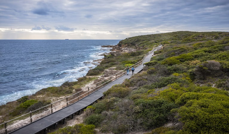
Dramatic cliff top views and rugged bushland make Malabar Headland National Park a popular spot for coast walks and fishing. Keep an eye out for humpbacks cruising the Pacific Ocean during whale watching season too.
Tucked between public beaches and parks, the natural landscape is dominated by towering cliffs, sandstone escarpments and remnant heritage structures. Get away from the urban crowds and discover expansive views all the way north to Bondi and south to La Perouse.
If you're looking to cool off in summer you'll find popular swimming spots nearby, with Maroubra Beach and Malabar Beach located near either end of Western Escarpment walking track and Boora Point walking track. And nature lovers will find several species of wildlife and protected vegetation, including the critically endangered eastern suburbs banksia scrub.
ANZAC Rifle Range
The eastern section of Malabar Headland National Park is subject to closure when the adjacent ANZAC Rifle Range is in use. This is the largest rifle range in the southern hemisphere and is headquarters to the New South Wales Rifle Association. Please check all safety messages and alerts before visiting.
Local alerts
For the latest updates on fires, closures and other alerts in this area, see https://www.nationalparks.nsw.gov.au/visit-a-park/parks/malabar-headland-national-park/local-alerts
Contact
- in the Sydney and surrounds region
Eastern section: Often closed because of the ANZAC rifle range operation. Closed every Saturday and every 1st and 3rd Sunday of the month. Check local alerts and safety messages before visiting.
Western section: Open all year but may close at times due to poor weather or fire danger.
-
-
Nielsen Park office
02 9337 5511
Contact hours: Monday to Friday, 9am to 5pm. - Greycliffe House, Nielsen Park, 6 Steele Point Road, Vaucluse NSW 2030
-
Email: npws.sydneysouth@environment.nsw.gov.au
-
Nielsen Park office
Visitor info
All the practical information you need to know about Malabar Headland National Park.
Map
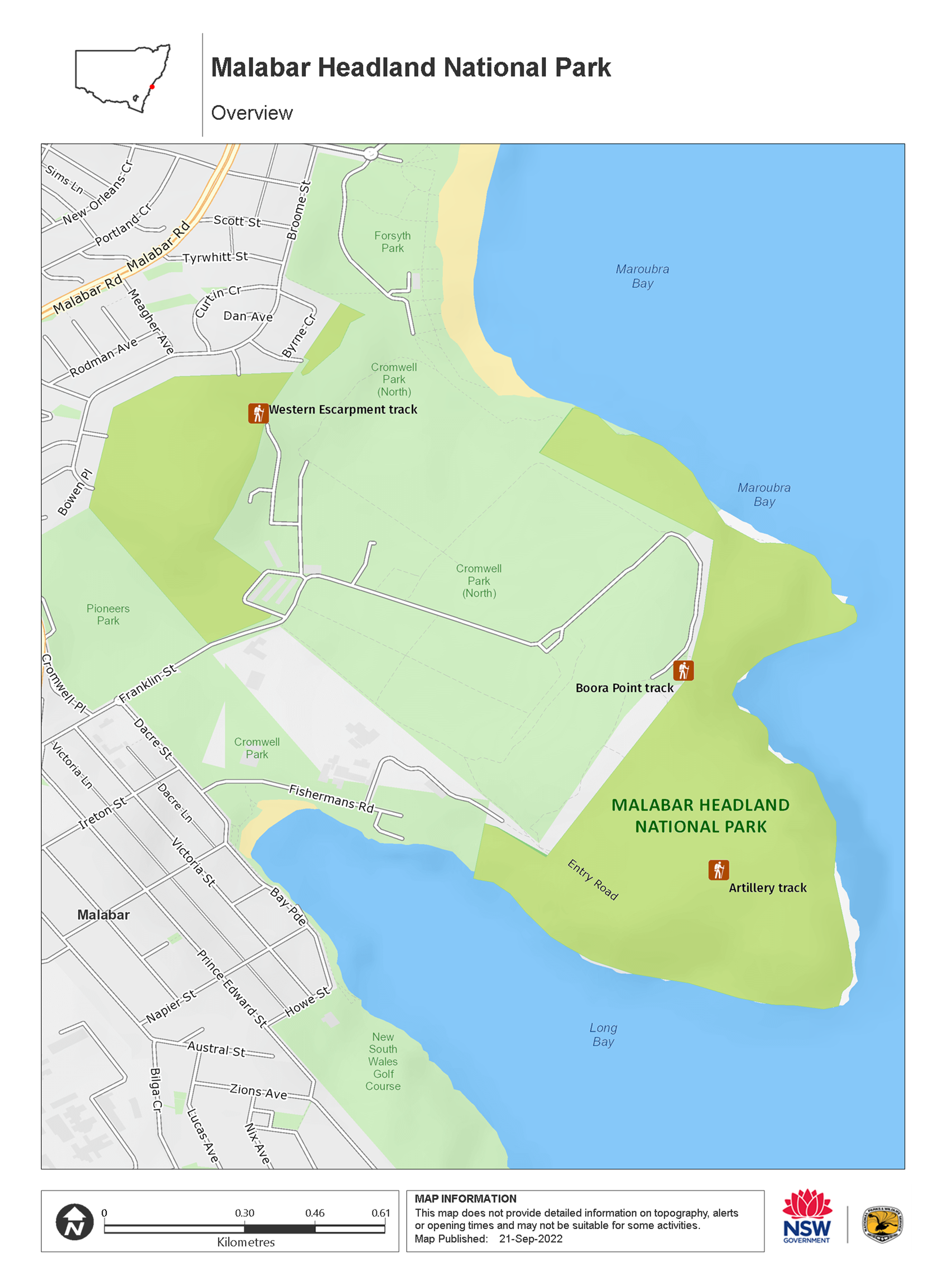
Map legend

Maps and downloads
Nearby towns
Maroubra
Famous for its consistent waves, Maroubra Beach is a popular destination for experienced surfers and beginners keen to learn from the local experts. The beach is 40 minutes by bus from the city centre.
Sydney City Centre
No trip to Sydney is complete without spending some time in the city’s beautiful parks. Whether it’s in central areas like Hyde Park or the Royal Botanic Gardens or further out in Centennial Parklands, there’s plenty of green space to go out and enjoy.
Learn more
Malabar Headland National Park is a special place. Here are just some of the reasons why:
Ancient landscapes

Malabar Headland National Park is part of the traditional land of the Bidjigal and Gadigal People. Malabar Headland is a significant area (Bora Ground) for Aboriginal people. The word Bora is used throughout Eastern Australia to describe an initiation site or ceremony.
Dramatic cliffs

Malabar Headland is home to many of the pre-colonial landscapes that once occurred throughout the eastern suburbs. You’ll find coastal rock platforms, sea cliffs and headlands in the eastern section, and sandstone escarpments and remnants of aeolian sand dunes in the western section. These were believed to have been formed as a result of the last major glacial period.
Plants a plenty

Alive with wildflowers in spring, Malabar Headland contains the last known population of the once extensive Port Jackson mallee in Sydney’s eastern suburbs. It’s also home to the eastern suburbs banksia scrub – one of the most critically endangered ecological communities in NSW. The park supports at least 7 distinct plant communities and this diversity of habitats is only matched in the eastern suburbs in Kamay Botany Bay National Park.
- Western Escarpment walking track Get back to nature on Western Escarpment walking track in Sydney's Malabar Headland National Park, near Maroubra. This short track through native heath boasts coastal views, bird life and wildflowers.
Walk the coast

If you’re keen for a walk with never-ending ocean views as your backdrop, follow the rugged coastal cliffs along Boora Point walking track which links to the iconic eastern beaches coastal walk. During whale watching season, you might even spot a whale or two on their annual migration.
Plants and animals protected in this park
Animals
-

Common ringtail possum (Pseudocheirus peregrinus)
Commonly found in forests, woodlands and leafy gardens across eastern NSW, the Australian ringtail possum is a tree-dwelling marsupial. With a powerful tail perfectly adapted to grasp objects, it forages in trees for eucalypt leaves, flowers and fruit.
-

Eastern bentwing-bat (Miniopterus schreibersii oceanensis)
Eastern bentwing-bats congregate in caves across the east and north-west coasts of Australia, in colonies of up to 150,000. These small Australian animals weigh around 13-17g and can reach speeds of up to 50km per hour. Eastern bentwing-bats use both sight and echolocation to catch small insects mid-air.
-

Humpback whale (Megaptera novaeangliae)
The humpback whale has the longest migratory path of any mammal, travelling over 5000km from its summer feeding grounds in Antarctica to its breeding grounds in the subtropics. Its playful antics, such as body-rolling, breaching and pectoral slapping, are a spectacular sight for whale watchers in NSW national parks.
-
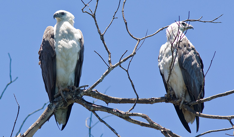
White-bellied sea eagle (Haliaeetus leucogaster)
White-bellied sea eagles can be easily identified by their white tail and dark grey wings. These raptors are often spotted cruising the coastal breezes throughout Australia, and make for some scenic bird watching. Powerful Australian birds of prey, they are known to mate for life, and return each year to the same nest to breed.
-

Yellow-tailed black cockatoo (Calyptorhynchus funereus)
The yellow-tailed black cockatoo is one of the largest species of parrot. With dusty-black plumage, they have a yellow tail and cheek patch. They’re easily spotted while bird watching, as they feed on seeds in native forests and pine plantations.
Environments in this park
What we're doing
Malabar Headland National Park has management strategies in place to protect and conserve the values of this park. View the detailed park and fire management documents.
Conserving our Aboriginal culture
Malabar Headland National Park aims to manage Aboriginal sites with guidance from the La Perouse Local Aboriginal Land Council. Ongoing research and maintenance of an Aboriginal sites register within the park is a priority in Malabar.
Developing visitor facilities and experiences
NPWS will continue to improve and maintain visitor park facilities such as walking tracks, lookouts, day use facilities and signage.
Historic heritage in our parks and reserves
Malabar has a unique historic heritage, NPWS will continue to work towards protecting these areas from vandalism and investigate safe options for public access.
Managing fire
Fire will be managed in accordance with Living with Fire in NSW National Parks – A strategy for managing bushfires in national parks and reserves 2012-2021. A Reserve Fire Management Strategy will be prepared for Malabar Headland National Park and made available to the public.
Preserving biodiversity
The biodiversity of Malabar Headland National Park is protected by minimising the impacts of visitor use, weeds and pest animals, and regenerating important plant communities using local endemic species.
Managing weeds, pest animals and other threats
Pests and weeds have a significant impact on the ecosystems within Malabar Headland National Park. NPWS, in conjunction with the community group Friends of Malabar Headland, carries out regular works to protect biodiversity in this park.