Overview
Discover Aboriginal cultural heritage along Giriwa walking track, in Meroo National Park. Enjoy the natural beauty of Burrill Lake, near Ulladulla, then stop for a picnic, swim or kayak.
- Where
- Meroo National Park in South Coast
- Accessibility
- No wheelchair access
- Distance
- 3km one-way
- Time suggested
- 1 - 2hrs
- Grade
- Grade 3
- What to
bring - Drinking water, hat, sunscreen, snacks, insect repellent
- Please note
- Giriwa walking track can be walked in either direction. A car shuffle is recommended if you have small children.
- The Gari walking track extension to Burrill Lake Rock Shelter is managed by Shoalhaven City Council.
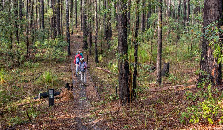
Located 10min from Ulladulla, or 35min from Batemans Bay, Giriwa walking track offers rich Aboriginal heritage, magnificent lake views, and great water activities.
Starting at Burrill Lake East picnic area, at the end of Burrill Lake Drive, the 3km track traces the southern shore of the lake to Western Arm picnic area. ‘Giriwa’ means goanna, and you may see the track’s namesake, or spot honeyeaters and crimson rosellas amongst the tallowwood and flowering black wattle.
Signs along the track highlight more than 20,000 years of continuous Aboriginal culture in this area. As you walk, learn about the strong Aboriginal connection to this land. Find out about bush medicines, or food like the edible native cherry, and cabbage tree palms which provide basket weaving material.
With picnic areas at each end of the walk, why not stop for a picnic on the lakeshore, or cool off with a swim. Burrill Lake is also a scenic spot to kayak, stand-up paddleboard, or go fishing.
This track is part of the longer Giriwa Bagan ‘goanna country’ walking trail, which includes Gari walking track. ‘Gari’ means snake, and this 1km extension snakes from the lake’s East picnic area to a fascinating Aboriginal rock shelter.
On the way
-
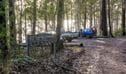
Burrill Lake East picnic area
Burrill Lake East picnic area is in Meroo National Park, on Giriwa walking track. It’s a great place to stop for snack, cool off with a swim, or set out in a kayak on Burrill Lake.
-
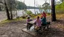
Burrill Lake Western Arm picnic area
Burrill Lake Western Arm picnic area is in Meroo National Park, on Giriwa walking track. It’s the perfect spot for a waterside picnic, or paddle in the lake before a walk.
Map
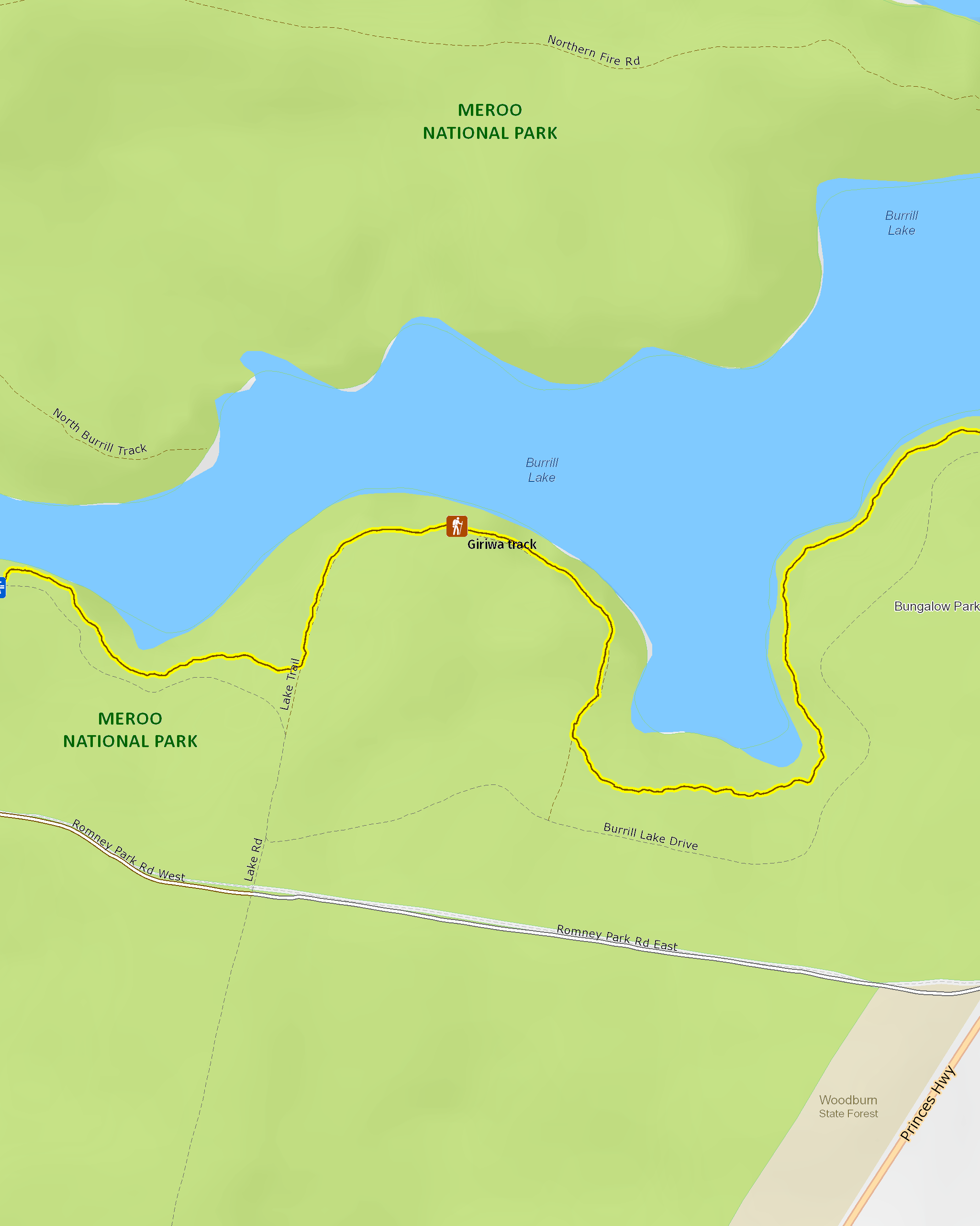
Map legend

Local alerts
For the latest updates on fires, closures and other alerts in this area, see https://www.nationalparks.nsw.gov.au/things-to-do/walking-tracks/giriwa-walking-track/local-alerts
General enquiries
- National Parks Contact Centre
- 7am to 7pm daily
- 1300 072 757 (13000 PARKS) for the cost of a local call within Australia excluding mobiles
- parks.info@environment.nsw.gov.au
Park info
- in Meroo National Park in the South Coast region
Meroo National Park is always open but may have to close at times due to poor weather or fire danger.
Visitor info
All the practical information you need to know about Giriwa walking track.
Track grading
Features of this track
Distance
3km one-way
Time
1 - 2hrs
Quality of markings
Clearly sign posted
Experience required
No experience required
Gradient
Gentle hills
Quality of path
Formed track, some obstacles: The walk is 1m-2m wide and mainly hard-packed ground with sections of fibre-reinforced polymer mesh. The track can be uneven and slippery at points.
Steps
Occasional steps: There are around 50 steps and drainage bars along the walk.
Other barriers
Pinch points: The fibre-reinforced polymer mesh sections narrow the track to around 0.8m wide.
Getting there and parking
Giriwa walking track is in the northern area of Meroo National Park. To get there:
From Ulladulla:
- Drive south on the Princes Highway and continue through Burrill Lake Village.
- Around 1.5km after crossing the bridge, turn right on to Romney Park Road.
- Follow the signs to Burrill Lake’s East picnic area or Western Arm picnic area, along Lake Road and Burrill Lake Drive.
- You can also take Wheelbarrow Road off the highway, then right on to Lake Road.
From Batemans Bay:
- Head north on the Princes Highway for around 47km.
- Before you reach Burrill Lake, turn left on to Wheelbarrow Road.
- Turn right onto Lake Road after about 1km, then follow the signs to the Burrill Lake’s East picnic area or Western Arm picnic area.
- You can also take Romney Park Road off the highway, then right on to Lake Road.
Road quality
- The unsealed roads to the East picnic area, and in particular to Western Arm picnic area, are not suitable for vehicles with trailers. 4WD vehicles are recommended.
- 2WD vehicles with low clearance should use caution even in dry weather.
- Please take care when turning on to Romney Park Road or Wheelbarrow Road from the busy Princes Highway. Directional signage is not provided from the highway.
- Unsealed roads
Vehicle access
- Most roads require 4WD vehicle
Weather restrictions
- 4WD required in wet weather
Parking
Limited parking is available in gravel carparks at Burrill Lake’s East picnic area and Western Arm picnic area.
Facilities
- The nearest public toilets are located at Burrill Lake Lions Park, off Princes Highway, south of the bridge in Burrill Lake Village.
- You’ll find picnic tables at the East and Western Arm picnic areas, at either end of the walk.
Carpark
Maps and downloads
Accessibility
Disability access level - no wheelchair access
Parts of Giriwa walking track that may be challenging for people with reduced mobility:
- There are around 50 steps and drainage bars along the track
- The ground can be uneven and slippery
- The crossings over the gullies along the track are narrow
- There are no seats or resting points along this walk
Permitted
Fishing
A current NSW recreational fishing licence is required when fishing in all waters.
Prohibited
- Cycling and horse riding are not permitted on this walking track, but are permitted on public roads and some management trails within Meroo National Park.
- Camping, campfires and generators are not permitted at the East or Western day use areas.
Pets
Pets and domestic animals (other than certified assistance animals) are not permitted. Find out which regional parks allow dog walking and see the pets in parks policy for more information.
Smoking
NSW national parks are no smoking areas.
Learn more
Giriwa walking track is in Meroo National Park. Here are just some of the reasons why this park is special:
Amazing wildlife haven

Meroo and Termeil Lakes are listed in the National Directory of Important Australian Wetlands and stand out for their abundance and diversity of mammals and frogs. The park also has at least 12 threatened wildlife species, including significant populations of the nationally endangered green and golden bell frog. As you explore the coastline keep a lookout to spot dolphins and whales off the coast. Thee's also excellent opportunities for birdwatching at Meroo. You'll see ducks, swans, pelicans, honeyeaters, superb blue wrens and pied oystercatchers. You might also spot sea eagles or an osprey soaring overhead. And if you're really lucky, you might even see a pair of hooded plover. There are less than 25 pairs known to occur in NSW, and the Meroo, Termeil and Willinga Lake entrances are prime breeding habitats for this vulnerable species.
- Meroo Lake walking track Wrap yourself in the tranquillity of calm coastal waters at Meroo Lake walking track. Enjoy paddling, swimming, fishing, birdwatching and walking in a pristine natural landscape.
- Tabourie Lake Tabourie Lake is a beautiful coastal lake ideal for fishing, paddling, windsurfing, swimming, walking and birdwatching.
Pristine natural landscapes

The coastal lakes, foreshores and wetlands you'll find in Meroo are outstanding examples of pristine natural environments. Only 10% of NSW estuaries remain in such a natural condition. This unspoilt landscape supports endangered ecological communities like the swamp oak floodplain forest and bangalay-banksia dry forest and helps to protect vulnerable plant species such as the tangled bedstraw and leafless tongue orchid.
- Meroo Head lookout walking track You can’t miss the spectacular coastal views from Meroo Head lookout walking track. It’s an easy walking track and a great place for birdwatching and whale watching.
- Nuggan Point walking track Go walking or mountain biking on this easy trail. Enjoy breathtaking coastal views, fishing, whale watching and birdwatching at Nuggan Point, then stop at Meroo Beach for a swim.
Rich Aboriginal culture

Meroo National Park forms part of the traditional lands of the Budawang and Murramarang tribes, who are part of the Dhurga language group. Meroo Lake has important spiritual significance for local Aboriginal groups because, along with other lakes in the region, it is connected to the Pigeon House Didthul creation stories that connect them with their country and ancestor spirits. The park is rich with archaeological sites including shell middens, open campsites, artefact scatters, stone arrangements, rock shelters and a burial site.
- Giriwa walking track Discover Aboriginal cultural heritage along Giriwa walking track, in Meroo National Park. Enjoy the natural beauty of Burrill Lake, near Ulladulla, then stop for a picnic, swim or kayak.
Plants and animals protected in this park
Animals
-

Green and golden bell frog (Litoria aurea)
The green and golden bell frog is an endangered Australian frog. Once common on the NSW coast and tablelands, populations have plummeted around 90 percent.
-

Humpback whale (Megaptera novaeangliae)
The humpback whale has the longest migratory path of any mammal, travelling over 5000km from its summer feeding grounds in Antarctica to its breeding grounds in the subtropics. Its playful antics, such as body-rolling, breaching and pectoral slapping, are a spectacular sight for whale watchers in NSW national parks.
-
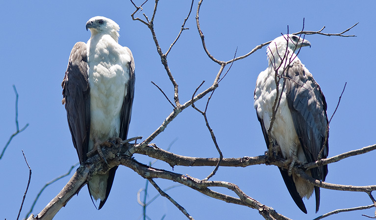
White-bellied sea eagle (Haliaeetus leucogaster)
White-bellied sea eagles can be easily identified by their white tail and dark grey wings. These raptors are often spotted cruising the coastal breezes throughout Australia, and make for some scenic bird watching. Powerful Australian birds of prey, they are known to mate for life, and return each year to the same nest to breed.