Tara Cave walking track
Warrumbungle National Park
Overview
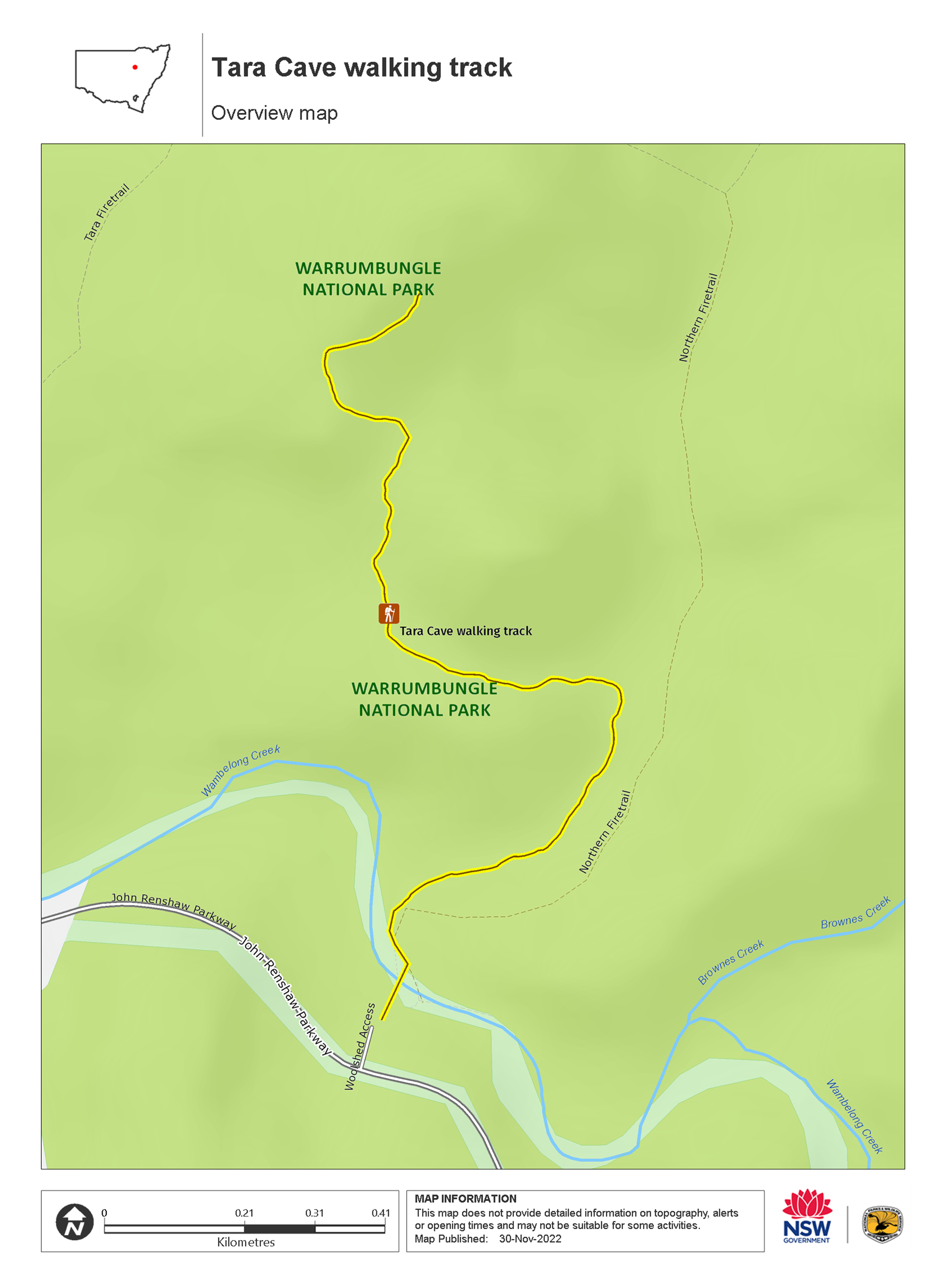
Tara Cave walking track is a gentle 3.4km return bushwalk through Warrumbungle National Park, near Coonabarabran. Learn about local Aboriginal culture and experience remarkable views.
- Where
- Warrumbungle National Park in Country NSW
- Accessibility
- Medium
- Distance
- 1.7km return
- Time suggested
- 1 - 2hrs
- Grade
- Grade 2
- Entry fees
- Park entry fees apply
- What to
bring - Drinking water, hat, sunscreen
- Please note
- This walk includes a creek crossing. Please check water level height at Warrumbungle National Park Visitor Centre before starting this walk. Take special care after heavy rain.
- Visit Warrumbungle National Park Visitor Centre before you set out to pick up a free trail map and get detailed route information and advice.
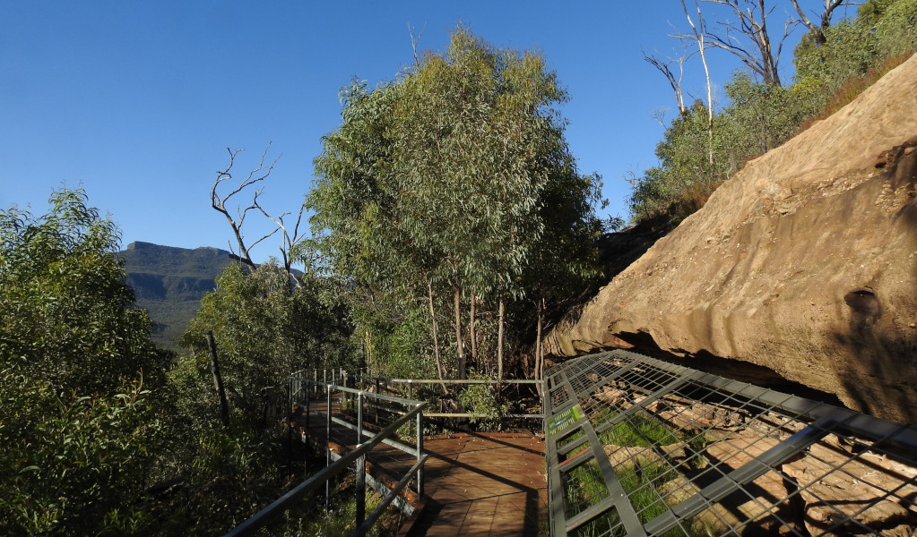
Tara Cave walking track is ideal for bushwalkers interested in the area’s Aboriginal culture. The track leads to Tara Cave, which has evidence of Aboriginal occupation, and along the way there are interpretive displays about the local Aboriginal people’s connection with the land.
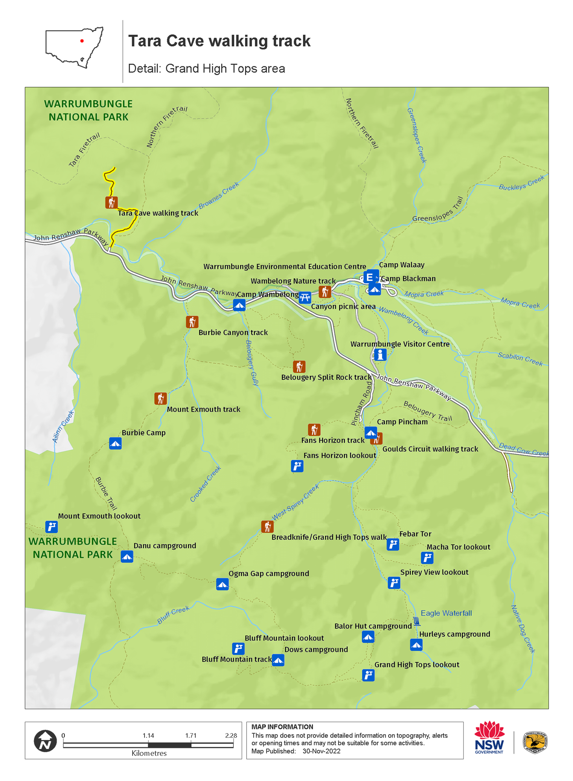
Starting at Old Woolshed picnic area, the trail leads you across Wambelong Creek and through a grassy valley. You’ll then gently climb through eucalypt forest to the remarkable Pilliga sandstone slopes. Here you’ll find Tara Cave and spectacular views of Warrumbungle National Park’s skyline.
Until recently, Aboriginal people used caves in the area for shelter. Tara Cave was also used for manufacturing stone tools, and you can see a stone slab with ‘grinding grooves’ at the cave entrance.
After your walk take a break and enjoy a picnic lunch at Old Woolshed picnic area or a barbeque at nearby Canyon picnic area. If you’re keen to see more of Warrumbungle National Park, combine Tara Cave walking track with a short walk to access-friendly Whitegum lookout.
Visit in spring to enjoy pleasant temperatures and an abundance of wildflowers, including yellow everlasting daisies and billy buttons. It’s also a great time to spot birdlife, including turquoise parrots and spotted pardalotes.
Map
Map
Map legend

Local alerts
For the latest updates on fires, closures and other alerts in this area, see https://www.nationalparks.nsw.gov.au/things-to-do/walking-tracks/tara-cave-walking-track/local-alerts
Park info
- in Warrumbungle National Park in the Country NSW region
Warrumbungle National Park is always open but may have to close at times due to poor weather or fire danger.
-
Park entry fees:
$8 per vehicle per day.
Buy annual pass.
Visitor info
All the practical information you need to know about Tara Cave walking track.
Maps and downloads
Visitor centre
-
Warrumbungle Visitor Centre
4261 John Renshaw Parkway, Warrumbungle NSW 2828 - 9am to 4pm daily. Closed Christmas Day.
- 02 6825 4364
Learn more
Tara Cave walking track is in Warrumbungle National Park. Here are just some of the reasons why this park is special:
Aboriginal dreamtime

Warrumbungle is a Gamilaraay word meaning crooked mountain, and for many thousands of years it has been a spiritual place for the custodians of this land, the Gamilaraay, the Wiradjuri and the Weilwan. The landscape, plants and animals of the park are a constant reminder of its sacred significance to Aboriginal people today. Take an Aboriginal Discovery guided tour to find out more about the Aboriginal cultural heritage.
- Tara Cave cultural tour Join this guided tour led by a local Aboriginal Discovery ranger. Discover the cultural heritage in the land of the Gamilaraay, Wiradjuri and Wailwan people in Warrumbungle National Park, near Coonabarabran.
- Tara Cave walking track Tara Cave walking track is a gentle 3.4km return bushwalk through Warrumbungle National Park, near Coonabarabran. Learn about local Aboriginal culture and experience remarkable views.
Diversity of wildlife

Warrumbungle National Park has a diversity of landforms and microclimates, and provides a habitat for hundreds of plant and animal species. Wildflowers and unique plants, such as the Warrumbungle star flower, golden cassinia and grey ray flower, flourish there. Over 190 bird species have been recorded in the park, including emus, wedge-tailed eagles and turquoise parrots. If you're lucky, you could also spot koalas, squirrel gliders, lace monitors and Warrumbungle black rock skinks high in the mountains. But for now, Warrumbungle's seriously endangered brush-tailed rock-wallabies have been relocated to a remote feral cat and fox-free area within the park. It's a secure environment where the rock-wallaby population can recover and thrive, free from predators.
- Boots and brushes - guided walk and art tour Tap into your creativity on a 6km guided walk with a Discovery ranger in Warrumbungle National Park. Create your own personal artwork inspired by the iconic mountain landscape at Spirey View lookout.
- Burbie Canyon walking track Burbie Canyon walking track in Warrumbungle National Park offers a gentle 2km stroll through a sandstone gorge, and is particularly popular for birdwatching.
- Tara Cave cultural tour Join this guided tour led by a local Aboriginal Discovery ranger. Discover the cultural heritage in the land of the Gamilaraay, Wiradjuri and Wailwan people in Warrumbungle National Park, near Coonabarabran.
- Walk on the wild side at the Warrumbungles Join an experienced Discovery Ranger and explore the beauty of Warrumbungle National Park. This tour is designed to bring your senses alive as you explore the sights, sounds and smells of this beautiful area.
- Whitegum lookout walking track Whitegum lookout walking track is a short, wheelchair-accessible walk in Warrumbungle National Park. Suitable for all ages, it offers remarkable views.
Landscape and geology

The landscape of Warrumbungle National Park has been shaped by millions of years of volcanic activity and erosion; spend some time looking at Crater Bluff and Belougery Spire and imagine the vents of magma that once erupted to create these formations. Layers of lava and volcanic rock created Mount Exmouth and Mount Woorut just outside the boundary of the park, and Belougery Split Rock and Bluff Mountain are great examples of igneous lava domes. One of the most iconic features in the park, The Breadknife, is a volcanic dyke which stands a massive 90m tall. You can learn more about the park's fascinating geological history, or take a self-guided geology tour, through the NSW GeoTours app.
- Bluff Mountain walking track Bluff Mountain walking track rewards experienced, fit bushwalkers with Warrumbungle National Park’s best views. This very long and challenging steep hike climbs past spectacular rock spires and domes—up to the summit of Bluff Mountain.
- Boots and brushes - guided walk and art tour Tap into your creativity on a 6km guided walk with a Discovery ranger in Warrumbungle National Park. Create your own personal artwork inspired by the iconic mountain landscape at Spirey View lookout.
- Breadknife and Grand High Tops walk Breadknife and Grand High Tops walk in Warrumbungle National Park, regarded as one of the best walks in NSW, offers close up views of the park’s iconic rock formations.
- Burbie Canyon walking track Burbie Canyon walking track in Warrumbungle National Park offers a gentle 2km stroll through a sandstone gorge, and is particularly popular for birdwatching.
- Coonabarabran - Baradine - Warrumbungle drive Explore the spectacular landscapes, historic towns, picnic spots and walks of the Warrumbungles and Pilliga, near Coonabarabran and Baradine, in NSW.
Wish upon a star

Warrumbungle National Park is Australia’s first Dark Sky Park. Nearby Coonabarabran is known as the 'Astronomy Capital of Australia'. Stargaze from your campsite, or if you want to see right up to the heavens, visit a local observatory. The dramatic mix of volcanic spires and domes, plateaus, forested ridges and tall volcanic dykes are bound to make even the youngest of photographers look good, so whatever you do ‐ don't forget your camera.
- Canyon picnic area Canyon picnic area is a fully accessible, family friendly picnic area in Warrumbungle National Park. Not far from the visitor centre, it features barbecues and tables.
- Warrumbungle Visitor Centre Visitor information is available at the Warrumbungle Visitor Centre, which is now back in its original location. Get great suggestions and tips for walking and camping in Warrumbungle National Park.
- Whitegum lookout Whitegum lookout in Warrumbungle National Park features spectacular views of the landscape and picnic tables. It is wheelchair accessible and an easy walk for children.
Plants and animals protected in this park
Animals
-

Wedge-tailed eagle (Aquila audax)
With a wingspan of up to 2.5m, the wedge-tailed eagle is Australia’s largest bird of prey. These Australian animals are found in woodlands across NSW, and have the ability to soar to heights of over 2km. If you’re bird watching, look out for the distinctive diamond-shaped tail of the eagle.
-

Superb fairy wren (Malurus cyaneus)
The striking blue and black plumage of the adult male superb fairy wren makes for colourful bird watching across south-eastern Australia. The sociable superb fairy wrens, or blue wrens, are Australian birds living in groups consisting of a dominant male, mouse-brown female ‘jenny wrens’ and several tawny-brown juveniles.
-

Southern boobook (Ninox novaeseelandiae)
The southern boobook, also known as the mopoke, is the smallest and most common native owl in Australia. With a musical 'boo-book' call that echoes through forests and woodlands, the southern boobook is a great one to look out for while bird watching.
-

Tawny frogmouth (Podargus strigoides)
Found throughout Australia, the tawny frogmouth is often mistaken for an owl due to its wide, powerful beak, large head and nocturnal hunting habits. The ‘oom oom oom’ call of this native bird can be heard echoing throughout a range of habitats including heath, woodlands and urban areas.
-

Kookaburra (Dacelo novaeguineae)
Of the 2 species of kookaburra found in Australia, the laughing kookaburra is the best-known and the largest of the native kingfishers. With its distinctive riotous call, the laughing kookaburra is commonly heard in open woodlands and forests throughout NSW national parks, making these ideal spots for bird watching.