Overview
Neranie Headland walking track is an easy short walk through historic sites offering scenic views over Myall Lakes near Seal Rocks.
- Where
- Myall Lakes National Park in North Coast
- Accessibility
- Hard
- Distance
- 1.4km return
- Time suggested
- 15 - 45min
- Grade
- Grade 3
- Entry fees
- Park entry fees apply
- Please note
- It’s a good idea to put sunscreen on before you set out and remember to take a hat and plenty of water.
- Remember to take your binoculars if you want to bird watch.
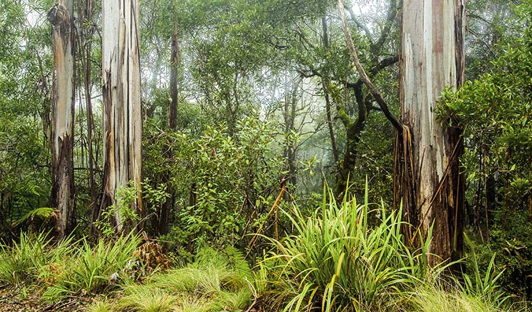
Neranie Headland walking track, near the eastern edge of Myall Lakes National Park, has breathtaking views over tree-lined waterways and wetlands teeming with wildlife. Starting in a clearing that was once a part of the historic Neranie timber mill village, the track leads past an old cemetery where you’ll find gravestones dating back to the nineteenth century.
Ascending the track to Neranie Headland, stop for a breather and take in the beauty of Myall Lakes fringed with swamp oak and paperbark. Birds flock to the wetlands and if you time your visit well, the chorus of the feisty friar birds and rainbow lorikeets will be almost deafening. Passing through a stand of towering black butt near the end of the track, finish off your adventure at nearby Hearts Point picnic area.
Map
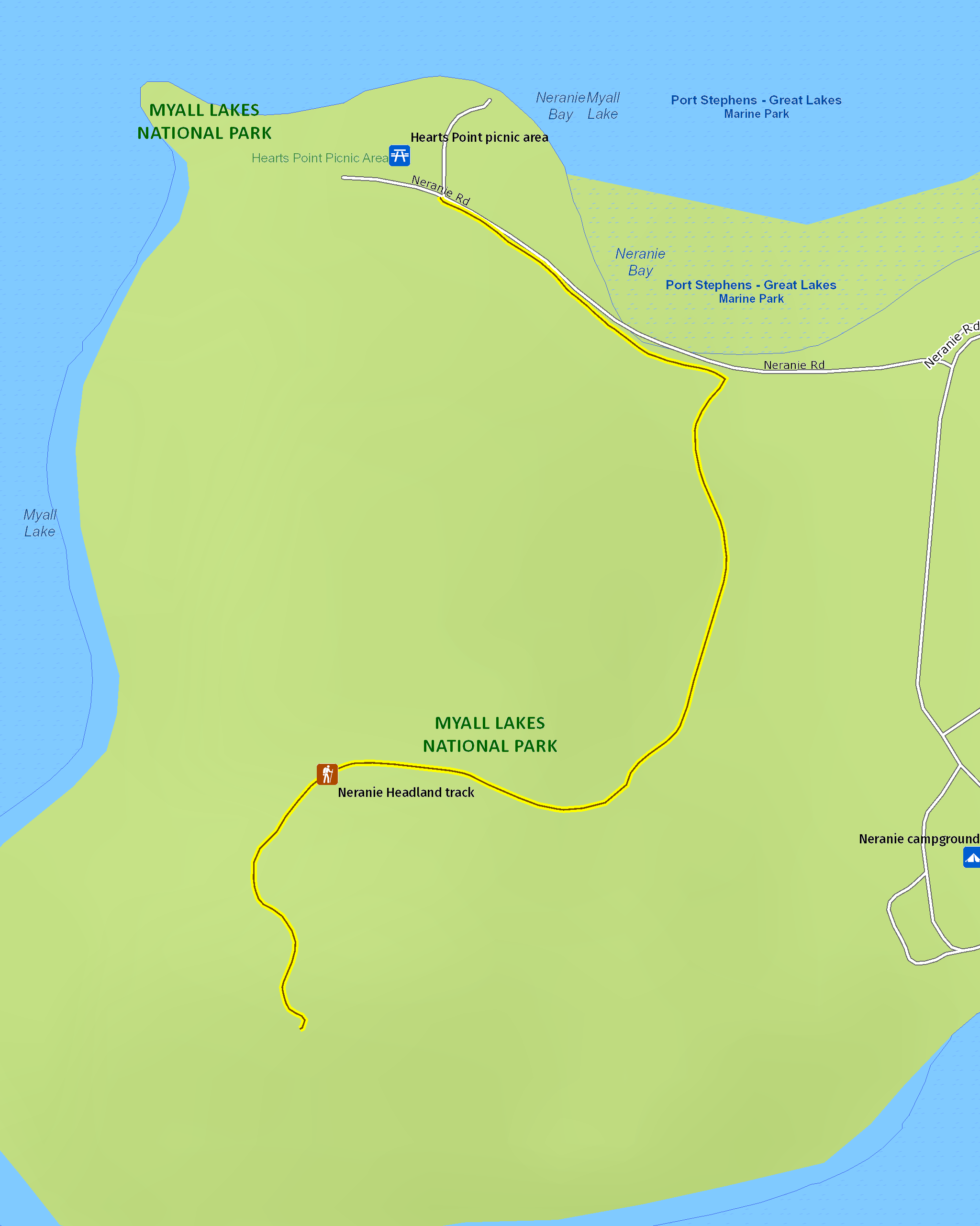
Map legend

Local alerts
For the latest updates on fires, closures and other alerts in this area, see https://www.nationalparks.nsw.gov.au/things-to-do/walking-tracks/neranie-headland-walking-track/local-alerts
General enquiries
- National Parks Contact Centre
- 7am to 7pm daily
- 1300 072 757 (13000 PARKS) for the cost of a local call within Australia excluding mobiles
- parks.info@environment.nsw.gov.au
Park info
- in Myall Lakes National Park in the North Coast region
Myall Lakes National Park is always open but may have to close at times due to poor weather or fire danger.
-
Park entry fees:
$8 per vehicle per day.
Day passes are available from a card operated pay machine at Mungo Brush campground or from the Manning Great Lakes Area Office. You can also pay for your visit via the Park’nPay app. You’ll need a Day Pass or Annual Pass when visiting the park.
Bombah Point ferry fees may also apply (cash payment only).
Buy annual pass.
Visitor info
All the practical information you need to know about Neranie Headland walking track.
Track grading
Features of this track
Distance
1.4km return
Time
15 - 45min
Quality of markings
Sign posted
Experience required
No experience required
Gradient
Gentle hills
Steps
Occasional steps
Quality of path
Formed track, some obstacles
Getting there and parking
Neranie Headland walking track starts at Hearts Point picnic area in the Myall Lake precinct of Myall Lakes National Park. To get there:
- From Pacific Highway, take The Lakes Way approximately 3km north of Bulahdelah.
- Drive for approximately 23km and turn right into Seal Rocks Road
- Turn right into Neranie Road and follow the signs to the picnic area
Parking
Parking is available in gravel carparks at Hearts Point picnic area where this walk begins.
Best times to visit
There are lots of great things waiting for you in Myall Lakes National Park. Here are some of the highlights.
Autumn
A good time to visit when the weather is a little cooler and the park is less busy.
Spring
Magnificent wildflower displays as they bloom across the heathlands.
Summer
Look for dolphins swimming among the waves.
Winter
Head to Sugarloaf Point to watch for whales on their annual migration.
Weather, temperature and rainfall
Summer temperature
Average
19°C and 27°C
Highest recorded
41.5°C
Winter temperature
Average
10°C and 19°C
Lowest recorded
1.1°C
Rainfall
Wettest month
May
Driest month
November
The area’s highest recorded rainfall in one day
257.8mm
Facilities
Picnic and toilet facilities are available at Hearts Point picnic area.
Maps and downloads
Accessibility
Disability access level - hard
There's a toilet at Hearts picnic area where this walk begins, but it's not accessible or ambulant.
Prohibited
Pets
Pets and domestic animals (other than certified assistance animals) are not permitted. Find out which regional parks allow dog walking and see the pets in parks policy for more information.
Smoking
NSW national parks are no smoking areas.
Learn more
Neranie Headland walking track is in Myall Lakes National Park. Here are just some of the reasons why this park is special:
Ancient connections

Myall Lakes National Park is part of the Country of the Worimi Aboriginal people, who used the area's natural resources, like freshwater lakes, the ocean and native flora and fauna to live a traditional fisher-hunter-gatherer lifestyle. Much evidence of their long connection with this Country can be seen today throughout the middens in the park. The landscape of Myall Lakes includes important spiritual sites that are an important part of the identity of local Aboriginal people. Make sure you visit Dark Point Aboriginal Place while you're at visiting the park. This rocky headland has been of significance to Worimi people for at least 4000 years. The clans or nuras (family groups) within the Worimi people would gather together here for ceremonies and feasts.
- Dark Point Aboriginal Place Dark Point Aboriginal Place, in southern Myall Lakes National Park, is a culturally significant site for the Worimi people with scenic coastal views across to Broughton Island.
- Mungo walking track Mungo walking track offers a variety of Aboriginal and historic sites, diverse vegetation, and mountain biking in Myall Lakes National Park, near Hawks Nest.
Go fish

Fishing is a popular activity in Myall Lakes, with catches likely to include bream, whiting, Australian salmon, flathead and mullet. There are lots of great places in the park to throw in a line, like the beaches, lakes or rivers. Try fishing from your boat or for a relaxing day on the water you could try a spot of kayak fishing. At Myall Lakes you can also go camping, boating, swimming and canoeing. And when you’ve tried all of those, you can explore the park on foot, by 4WD or bike, stopping for a spot of bird watching or to enjoy a picnic or barbecue lunch along the way. Whatever your interests, there is bound to be something that takes your fancy.
- Mining Road to Old Gibber Road cycling trail Mining Road to Old Gibber Road cycling trail is an easy bike ride within Myall Lakes National Park. You can complete the ride in one day or take your tent to camp overnight.
- Mungo Rainforest walk Enjoy a short and easy rainforest walk with the birds in Myall Lakes National Park, not far from Buladelah. Afterwards, you can enjoy a picnic or barbecue at Mungo Brush.
Internationally recognised wetlands

Since 1999, this internationally recognised wetlands site, has been listed under the Ramsar Convention due to its diverse mosaic of near-natural wetlands, within a relatively unmodified coastal lake system. There are 18 different wetland types with extensive interconnected lake and river systems within the forested wetlands and swamps that fringe the waterways, rocky and sandy shores, and offshore islands off the coastline. This wetland site houses a complex variety of habitats with rich biodiversity, including threatened species and migratory birds protected under international agreements. The Myall Lakes wetlands also have a high cultural and social value as they occur within the traditional lands of the Worimi Aboriginal people, where the varied wetlands, environments and abundant resources provided an ideal living environment. Evidence of this traditional occupation exists across the landscape, including the Dark Point Aboriginal Place.
Plants and animals protected in this park
Animals
-
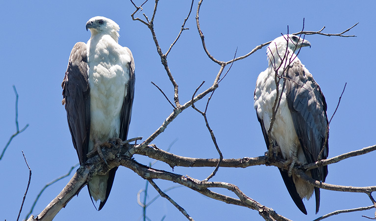
White-bellied sea eagle (Haliaeetus leucogaster)
White-bellied sea eagles can be easily identified by their white tail and dark grey wings. These raptors are often spotted cruising the coastal breezes throughout Australia, and make for some scenic bird watching. Powerful Australian birds of prey, they are known to mate for life, and return each year to the same nest to breed.
-

Long-nosed bandicoot (Perameles nasuta)
A nocturnal marsupial and one of the smaller Australian native animals, the long-nosed bandicoot is found across eastern Australia. Populations in the Sydney region have dwindled since European settlement, leaving only endangered colonies in inner western Sydney and at North Head, near Manly. The long-nosed bandicoot has grey-brown fur and a pointed snout which it uses to forage for worms and insects.
-

Brown-striped frog (Lymnastes peronii)
One of the most common frogs found in Australia, the ground-dwelling brown-striped frog lives in ponds, dams and swamps along the east coast. Also known as the striped marsh frog, this amphibian grows to 6.5cm across and has a distinctive ‘tok’ call that can be heard all year round.
-

Grey-headed flying-fox (Pteropus poliocephalus)
The grey-headed flying fox is Australia's largest native bat, with a wingspan up to 1m. This threatened species travels up and down south-eastern Australia and plays a vital role in pollinating plants and spreading seeds in our native forests.
-

Green and golden bell frog (Litoria aurea)
The green and golden bell frog is an endangered Australian frog. Once common on the NSW coast and tablelands, populations have plummeted around 90 percent.
Plants
-

Cabbage palm (Livistona australis)
With glossy green leaves spanning 3-4m in length and a trunk reaching a height of up to 30m, the cabbage tree palm, or fan palm, is one of the tallest Australian native plants. Thriving in rainforest margins along the east coast of NSW, in summer this giant palm produces striking spikes of cream flowers which resemble cabbages.
-
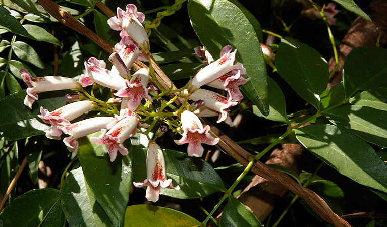
Wonga wonga vine (Pandorea pandorana)
The wonga wonga vine is a widespread vigorous climber usually found along eastern Australia. A variation of the plant occurs in the central desert, where it resembles a sprawling shrub. One of the more common Australian native plants, the wonga wonga vine produces bell-shaped white or yellow flowers in the spring, followed by a large oblong-shaped seed pod.