Overview
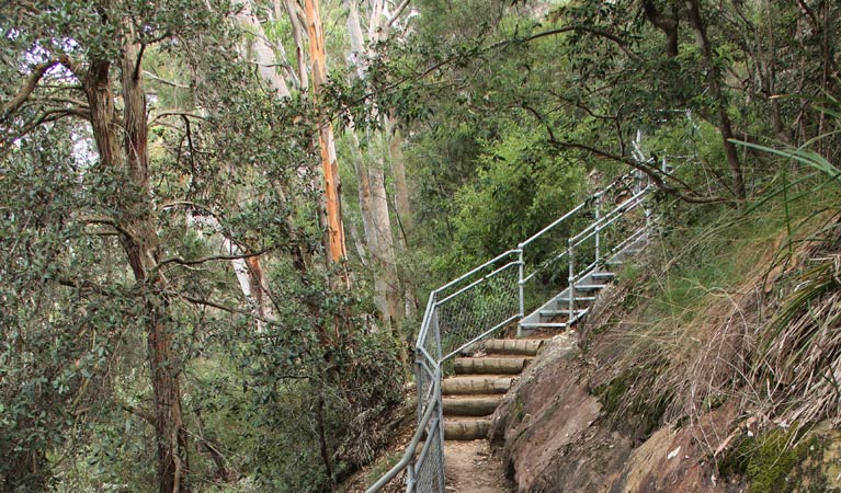
Caleys lookout track is a short and steep walk through bushland of Bents Basin State Conservation Area near Penrith. Take your lunch – it’s a great spot for a picnic.
- Distance
- 1.2km return
- Time suggested
- 15 - 45min
- Grade
- Grade 4
- Trip Intention Form
-
It's a good idea to let someone know where you're going. Fill in a trip intention form to send important details about your trip to your emergency contact.
- Entry fees
- Park entry fees apply
- What to
bring - Drinking water, hat, sunscreen, sturdy shoes
- Please note
- Remember to wear suitable walking shoes, as this track is quite steep
- Please note that park gates lock automatically after hours
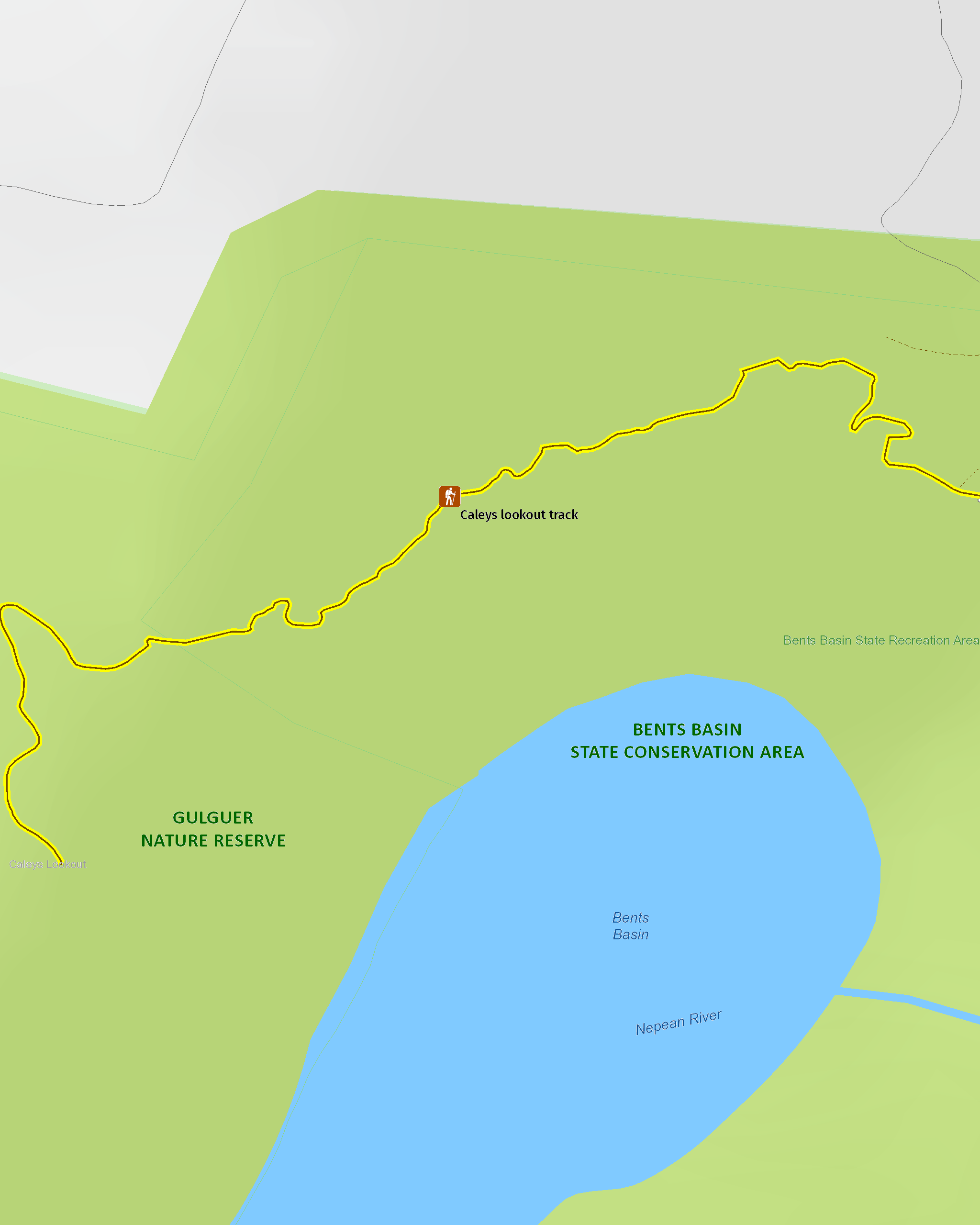
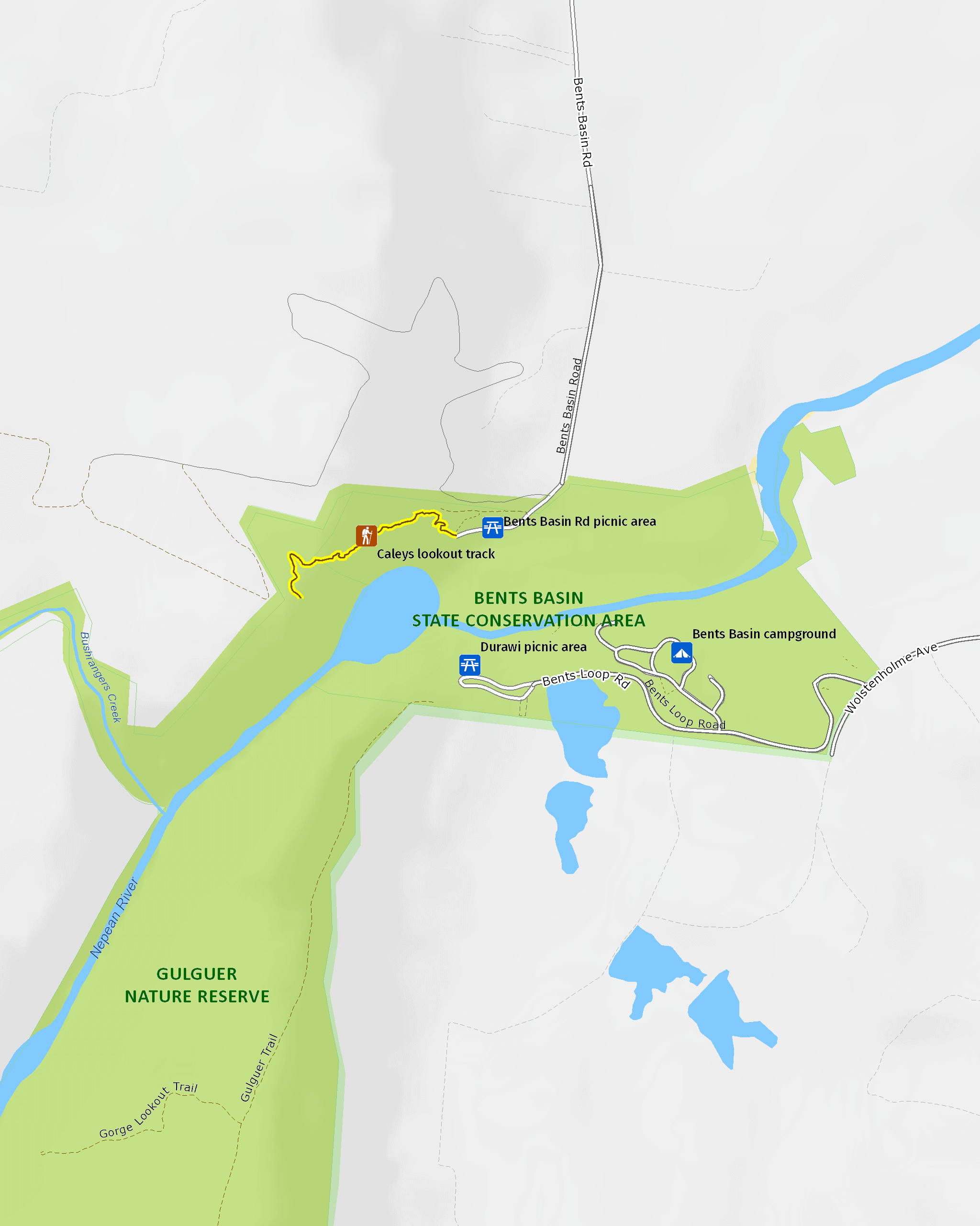
Take in delightful views on the Caleys lookout track in Bents Basin State Conservation Area, not far from Penrith. Named after English explorer and botanist, George Caley, the lookout track follows a shady path from the Bents Basin Road picnic area up into the forested escarpment. Children might find it a bit steep, although you’re assisted by stone, wooden and metal steps along the way.
At the end of the walk is Caleys lookout located in the neighbouring Gulguer Nature Reserve. There are picnic tables at the fenced lookout, so you can bring along a picnic lunch to tuck into while you enjoy expansive views over the tall eucalypts above Bents Basin.
You can also look across to Bents Basin campground, taking in the vista of pretty patchwork farmland and rugged bushland of western Sydney. There are picnic tables at the lookout, so you can bring along a picnic lunch to tuck into while you’re admiring the view.
Map
Map
Map legend

Local alerts
For the latest updates on fires, closures and other alerts in this area, see https://www.nationalparks.nsw.gov.au/things-to-do/walking-tracks/caleys-lookout-track/local-alerts
General enquiries
- National Parks Contact Centre
- 7am to 7pm daily
- 1300 072 757 (13000 PARKS) for the cost of a local call within Australia excluding mobiles
- parks.info@environment.nsw.gov.au
Park info
- in Bents Basin State Conservation Area in the Sydney and surrounds region
Bents Basin State Conservation Area is open 8am to 6pm from May to August and 8am to 8pm from September to April. The park may have to close at times due to poor weather or fire danger.
-
Park entry fees:
$8 per vehicle per day. Day passes are available from on-park pay machines that accept coins and credit cards, and you can also pay for your visit via the Park’nPay app.
Buy annual pass.
Visitor info
All the practical information you need to know about Caleys lookout track.
Track grading
Features of this track
Distance
1.2km return
Time
15 - 45min
Quality of markings
Limited signage
Experience required
No experience required
Gradient
Short steep hills
Steps
Many steps
Quality of path
Formed track
Getting there and parking
Caleys lookout track starts at Bents Basin Road picnic area in the northern precinct of Bents Basin State Conservation Area. To get there:
- From Wallacia, follow Silverdale Road west
- Turn left onto Bents Basin Road and continue to the end
- At Bents Basin Road picnic area the trackhead is located to the west of the carpark.
Bents Basin Road picnic area is also accessible by foot from southern precinct of the park by taking the footpath across the short bridge next to the water.
Parking
Parking is available at Bents Basin Road picnic area
Best times to visit
Bents Basin State Conservation Area is a great place to visit all year round. Head to the park for a camping weekend in spring, a weekend picnic in the winter sun or a sunny summer day for lots of water activities.
Weather, temperature and rainfall
Summer temperature
Average
15°C and 29°C
Highest recorded
45°C
Winter temperature
Average
3°C and 16°C
Lowest recorded
-6°C
Rainfall
Wettest month
February
Driest month
July
The area’s highest recorded rainfall in one day
156mm
Maps and downloads
Prohibited
Pets
Pets and domestic animals (other than certified assistance animals) are not permitted. Find out which regional parks allow dog walking and see the pets in parks policy for more information.
Smoking
NSW national parks are no smoking areas.
Learn more
Caleys lookout track is in Bents Basin State Conservation Area. Here are just some of the reasons why this park is special:
Aboriginal heritage

Bents Basin State Conservation Area is the traditional land of the Gundungurra, Dharawal and Darug people. Also known as Gulguer (meaning whirlpool or spinning), Bents Basin is associated with an awful aquatic creature called Gurungadge or Gurungaty. This creature is prominent in the area's ancestral stories. Archaeological finds suggest the area was also an important trading place. Bents Basin and the adjoining Gulguer Nature Reserve protect a variety of Aboriginal rock art and artefacts.
Bygone days

Explorer and botanist George Caley was the first European to visit the area in 1802 and afterwards collected plant specimens for preservation. The area was later used as a stopping point for early settlers travelling from the developing east. If you're interested in the local history of western Sydney, be sure to check out the historic inn. Established in the 1860s and used by Cobb & Co, the inn is listed on both the State and National Heritage Register. You'll find it near the Peppercorn Tree in Durrawi picnic area.
Fascinating and fun

The basin itself is what draws most people here. Known as a scour pool, this geological formation is like a small lake, created over time by fast-flowing floodwaters exiting the gorge about 30-40km/hr. At 22m deep, its waters travel 150km before reaching the ocean. In addition to that, it's heaps of fun to visit for a spot for swimming, fishing, paddling and liloing.
Rare communities

A visit to the park allows you to see majestic Camden white gums in one of only two known naturally-occurring populations. Look out also for Cumberland Plain woodland which once blanketed almost 30% of the Sydney Basin. Today, its scattered fragments cover less than 6% and remain under threat. Important fauna species include the regent honey eater, Cumberland Plain land snail, eastern bentwing bat, sooty owl and the glossy black cockatoo.
- Caleys lookout track Caleys lookout track is a short and steep walk through bushland of Bents Basin State Conservation Area near Penrith. Take your lunch – it’s a great spot for a picnic.
Plants and animals protected in this park
Animals
-

Brown-striped frog (Lymnastes peronii)
One of the most common frogs found in Australia, the ground-dwelling brown-striped frog lives in ponds, dams and swamps along the east coast. Also known as the striped marsh frog, this amphibian grows to 6.5cm across and has a distinctive ‘tok’ call that can be heard all year round.
-

Eastern snake-necked turtle (Chelodina longicollis)
Found across most of NSW, the eastern snake-necked turtle, also known as the eastern long-necked turtle, can be found in swamps, lakes and inland waterways. This freshwater turtle is carnivorous and lives most of its life submerged on the water’s edge, searching for worms and snails.
-

Common brushtail possum (Trichosurus vulpecula)
One of the most widespread of Australian tree-dwelling marsupials, the common brushtail possum is found across most of NSW in woodlands, rainforests and urban areas. With strong claws, a prehensile tail and opposable digits, these native Australian animals are well-adapted for life amongst the trees.
-

Eastern blue-tongue lizard (Tiliqua scinciodes)
The eastern blue-tongue lizard, one of the largest skinks in Australia, is found throughout most of NSW. When threatened, the eastern blue-tongue lizard displays its blue tongue in a wide-mouthed intimidating show. Not an agile animal, they feed on slow-moving beetles and snails.
-
Cumberland Plain land snail (Meridolum corneovirens)
The endangered Cumberland Plain land snail is only found on the Cumberland Plain, west of Sydney. During drought it digs deep into the soil to escape harsh conditions. Its brown shell is thin and fragile.
Environments in this park
General enquiries
- National Parks Contact Centre
- 7am to 7pm daily
- 1300 072 757 (13000 PARKS) for the cost of a local call within Australia excluding mobiles
- parks.info@environment.nsw.gov.au
Operated by
- Scheyville office
- Monday to Friday, 8.30am to 4.30pm. Closed public holidays.
- 02 4580 2750
- npws.cumberland@environment.nsw.gov.au
- 71 Memorial Drive, Scheyville 2756
Park info
- in Bents Basin State Conservation Area in the Sydney and surrounds region
Bents Basin State Conservation Area is open 8am to 6pm from May to August and 8am to 8pm from September to April. The park may have to close at times due to poor weather or fire danger.
-
Park entry fees:
$8 per vehicle per day. Day passes are available from on-park pay machines that accept coins and credit cards, and you can also pay for your visit via the Park’nPay app.
Buy annual pass
What's nearby:
Things to do (16)
- Birdwatching and wildlife encounters (3)
- Canoeing/paddling (2)
- Environmental appreciation/study (2)
- Fishing (1)
- Historic heritage (1)
- Other experiences (1)
- Picnics and barbecues (4)
- Road trips and car/bus tours (1)
- Sightseeing (6)
- Swimming (3)
- Walking (5)