Overview
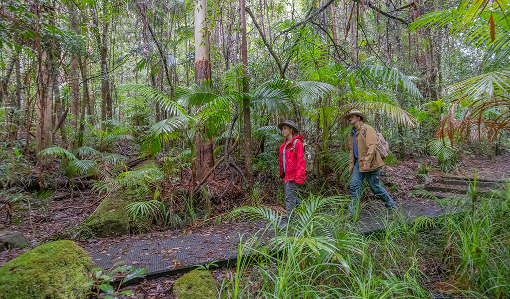
Historic Nightcap walking track leads through World Heritage-listed rainforest, offering scenic views across Nightcap National Park and Whian Whian State Conservation Area, near Byron Bay.
- Distance
- 18km one-way
- Time suggested
- 1 - 2 days
- Grade
- Grade 4
- Trip Intention Form
-
It's a good idea to let someone know where you're going. Fill in a trip intention form to send important details about your trip to your emergency contact.
- Please note
- It’s advisable to contact the local NPWS office when planning an overnight or extended walk to get the best information on the track, weather conditions and possible closures.
- Check the weather before you set out as the road to Historic Nightcap walking track can become boggy when it rains.
- It’s a good idea to bring a topographic map and compass, or a GPS.
- The weather in the area can be extreme and unpredictable, so please ensure you’re well-prepared for your visit.
- This walking track is in a remote location; bring appropriate clothing and equipment, and advise a family member or friend of your travel plans.
- This walking track is suitable for experienced bushwalkers who are comfortable undertaking self-reliant hiking.
- Groups of 3-5 people are recommended, with at least one experienced bushwalker in the group.
- A Personal Locator Beacon is advisable, but should only be used in a life-threatening situation.
- There are camping facilities at Rummery Park.
- It’s a good idea to pack sunscreen and remember to take a hat.
- You’re encouraged to bring gas or fuel stoves, especially in summer during the fire season.
Head along Historic Nightcap walking track to experience a World Heritage rainforest with breathtaking escarpment views across Nightcap National Park. This 18km track is popular with experienced walkers looking for a remote wilderness adventure.
With the option to camp overnight at Rummery Park campground, west to east is the easiest way to take this scenic walk, but you can easily start at either end of the track.
During the 1800s and 1900s, sections of Historic Nightcap walking track were traversed by travellers and postal workers making their way between Lismore and Murwillumbah.
There’s plenty to see along the way, so remember to pack your camera and capture shots of rock orchids brightening the path, and wildlife such as the long-nosed potoroo, brush turkey and Albert’s lyrebird, who call the area home.
Map
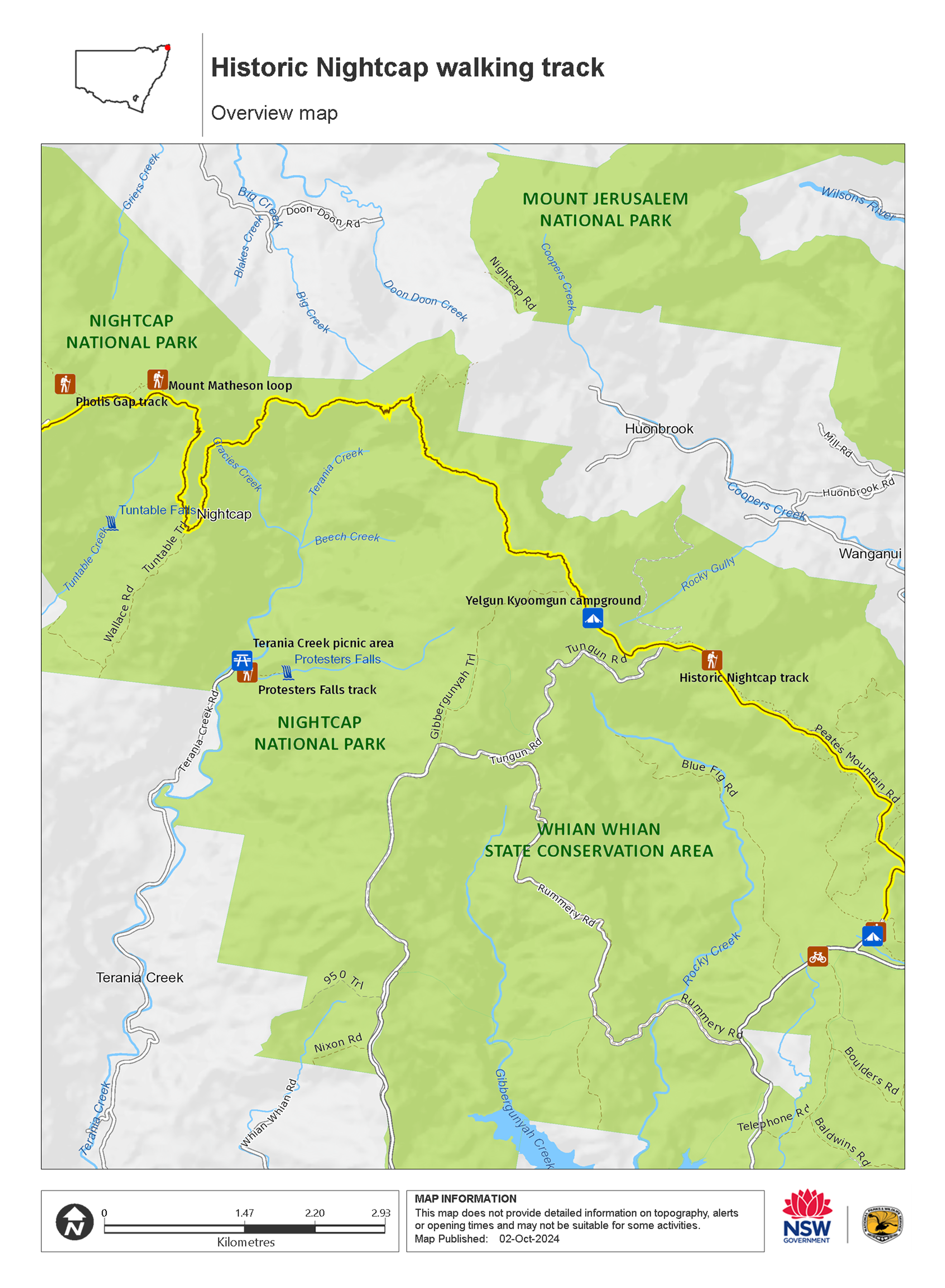
Map legend

Local alerts
For the latest updates on fires, closures and other alerts in this area, see https://www.nationalparks.nsw.gov.au/things-to-do/walking-tracks/historic-nightcap-walking-track/local-alerts
General enquiries
- National Parks Contact Centre
- 7am to 7pm daily
- 1300 072 757 (13000 PARKS) for the cost of a local call within Australia excluding mobiles
- parks.info@environment.nsw.gov.au
Park info
- in Whian Whian State Conservation Area in the North Coast region
Whian Whian State Conservation Area is always open but may have to close at times due to poor weather.
- in Nightcap National Park in the North Coast region
Nightcap National Park is always open but may have to close at times due to poor weather, fire danger or management operations.
Visitor info
All the practical information you need to know about Historic Nightcap walking track.
Track grading
Features of this track
Distance
18km one-way
Time
1 - 2 days
Quality of markings
Sign posted
Experience required
Experienced bushwalkers
Gradient
Very steep
Steps
No steps
Quality of path
Rough track, many obstacles
Getting there and parking
Historic Nightcap walking track is in the western precinct of Nightcap National Park. To get there:
From Nimbin:
- Take Sibley Street and drive past Nimbin Bowling Club
- Turn onto Gungas Street and continue for 1.5km, then turn right onto Tuntable Falls Road - signposted ‘Mount Nardi’.
- Travel a further 4.2km, past Upper Tuntable Falls Road intersection, where the road turns onto Newton Drive.
- Continue for approximately 4.8km to the park entrance, and another 1km to Mount Nardi carpark.
From the eastern park entrance (via Rosebank):
- Take Minyon Drive, past Minyon Falls picnic area, over the causeway.
- Continue along Minyon Drive until you reach the Peates Mountain Road intersection
- Turn right onto Peates Mountain Road – the track is approximately 100m to the north (approximately 4km).
From the southern park entrance on Nightcap Range Road (via Dunoon):
- Continue north up Nightcap Range Road to the top of the range
- Turn left onto Peates Mountain Road – the track is approximately 100m north (approximately 5km).
Parking
Parking is available at Mount Nardi carpark.
Best times to visit
There are lots of great things waiting for you in Nightcap National Park. Here are some of the highlights: Weather in the northern rivers region is generally mild in winter ranging to hot in summer. It can be very wet (the park receives the highest annual rainfall in NSW) and misty so check local weather conditions and pack suitable clothes as well as a hat, sunscreen and insect repellent.
Weather, temperature and rainfall
Summer temperature
Average
18°C and 29°C
Highest recorded
40°C
Winter temperature
Average
6°C and 19°C
Lowest recorded
-0.6°C
Rainfall
Wettest month
February
Driest month
September
The area’s highest recorded rainfall in one day
350mm
Facilities
Drinking water
Drinking water is not available in this area, so it’s a good idea to bring your own.
Maps and downloads
Prohibited
Pets
Pets and domestic animals (other than certified assistance animals) are not permitted. Find out which regional parks allow dog walking and see the pets in parks policy for more information.
Smoking
NSW national parks are no smoking areas.
Learn more
Historic Nightcap walking track is in Whian Whian State Conservation Area. Here are just some of the reasons why this park is special:
4,000 years of Aboriginal culture

The conservation area is located within the traditional lands of the Widjabal clan of the Bundjalung Nation. Evidence from recorded sites suggests Aboriginal use of the Nightcap Range for at least the last 4,000 years. The area has intrinsic cultural values to the Widjabal People and the land has significant connections with other recorded sites in the adjacent Nightcap National Park.
- Byan Yangala loop walk Travel back in time as you walk through ancient Gondwana rainforest on the Byan Yangala loop walk. Immerse yourself in nature less than 1 hour from Byron Bay.
Historic heritage of timber-getters

Lured by the opportunity of employment in difficult times, timber-getters began logging in the Whian Whian area in the 1830s for red cedar, a particularly sought after timber. In 1871, surveyors identified a track over Nightcap Range to link Lismore with Murwillumbah. This allowed cedar-getters access to previously isolated expanses of forest. The Rummery Park campground was originally a forestry camp, and its use dates back to the 1930s. The inter-war period was the most active period for forestry use of the campground. Peates Mountain Road (now part of the Nightcap track) was built during the depression of the 1920s and 1930s. Sleeper-cutters who claimed timber unsuitable for milling, camped nearby on the other side of Boggy Creek at Rummery Park.
- Historic Nightcap walking track Historic Nightcap walking track leads through World Heritage-listed rainforest, offering scenic views across Nightcap National Park and Whian Whian State Conservation Area, near Byron Bay.
Plant life galore

An astounding 520 plant species have been recorded here – making it an incredibly diverse place when it comes to vegetation. There are 10 broad ecosystems, including subtropical and warm temperate rainforests and various types of wet sclerophyll forest.
- Boggy Creek walk Boggy Creek walk in Whian Whian State Conservation Area takes you through blackbutt forest and along the beautiful Boggy Creek to Minyon Falls. You can swim in the inviting pools along the creek.
- Historic Nightcap walking track Historic Nightcap walking track leads through World Heritage-listed rainforest, offering scenic views across Nightcap National Park and Whian Whian State Conservation Area, near Byron Bay.
Walk with the animals

There’s also an incredible variety of native animal species thriving in these rainforests – over 270 native species, around 50 of which are listed as threatened, including the spotted tailed quoll. Koalas and Albert’s lyrebird, with its distinctive calls and mimicking echoes, can often be heard through the forest in the cooler months.
- Byan Yangala loop walk Travel back in time as you walk through ancient Gondwana rainforest on the Byan Yangala loop walk. Immerse yourself in nature less than 1 hour from Byron Bay.
- Whian Whian mountain biking trails Suitable for bushwalkers, cyclists and horseriders, Whian Whian mountain biking trails near Byron Bay offer stunning views of waterfalls and rainforest.
World heritage worthy

The conservation area has similar vegetation and natural heritage values as those found in the adjoining Nightcap National Park, one of the 50 reserves in northeast NSW and southeast Queensland that make up World Heritage Central Eastern Rainforest Reserves Australia.
- Whian Whian mountain biking trails Suitable for bushwalkers, cyclists and horseriders, Whian Whian mountain biking trails near Byron Bay offer stunning views of waterfalls and rainforest.
Plants and animals protected in this park
Animals
-

Albert's lyrebird (Menura alberti)
The Albert’s lyrebird is much rarer than the superb lyrebird. Distinguished by its richer brown plumage and less elaborate tail feathers, it’s protected as a threatened species in NSW.
-

Koala (Phascolarctos cinereus)
One of the most renowned Australian animals, the tree-dwelling marsupial koala can be found in gum tree forests and woodlands across eastern NSW, Victoria and Queensland, as well as in isolated regions in South Australia. With a vice-like grip, this perhaps most iconic but endangered Australian animal lives in tall eucalypts within a home range of several hectares.
-

Common brushtail possum (Trichosurus vulpecula)
One of the most widespread of Australian tree-dwelling marsupials, the common brushtail possum is found across most of NSW in woodlands, rainforests and urban areas. With strong claws, a prehensile tail and opposable digits, these native Australian animals are well-adapted for life amongst the trees.
-

Kookaburra (Dacelo novaeguineae)
Of the 2 species of kookaburra found in Australia, the laughing kookaburra is the best-known and the largest of the native kingfishers. With its distinctive riotous call, the laughing kookaburra is commonly heard in open woodlands and forests throughout NSW national parks, making these ideal spots for bird watching.