Brimbin Nature Reserve
Overview
Brimbin Nature Reserve, located on the NSW Mid North Coast, only 9km north of Taree, is a great spot for canoeing, walking, birdwatching and picnicking.
Read more about Brimbin Nature Reserve
Brimbin Nature Reserve is just a stone’s throw from Taree and a tranquil place of mangrove-lined waterways for canoeing, short trails for walking and shady areas for picnicking. Yet, over the century following European settlement of this area – the traditional land of the Biripi Nation – the place had a surprisingly dynamic history.
Along with being the site of significant stock routes, bullock roads and river crossings, it was also part of a property owned by New South Wales’ only independent female colonial settler, Isabella Mary Kelly. Ms Kellys walking track and Ms Kellys Crossing were named in her honour. Tommy Owens Crossing and Creek are in memory of the 12-year-old boy who drowned here in 1850.
Enjoy picnicking by the riverside, canoeing down the waterways, or walking leisurely along one of the reserve’s two walking trails. Brimbin is also teeming with birdlife, so if you’re keen on birdwatching, be sure to tuck your binoculars in the picnic basket.
Local alerts
For the latest updates on fires, closures and other alerts in this area, see https://www.nationalparks.nsw.gov.au/visit-a-park/parks/brimbin-nature-reserve/local-alerts
Contact
- in the North Coast region
Brimbin Nature Reserve is always open but may have to close at times due to flood events, poor weather or fire danger.
-
-
Taree office
02 6552 4097
Contact hours: Monday to Friday, 9am to 4.30pm. - 78 Hargreaves Drive, Taree NSW 2430
-
Email: npws.manninggreatlakes@environment.nsw.gov.au
-
Taree office
Visitor info
All the practical information you need to know about Brimbin Nature Reserve.
Map
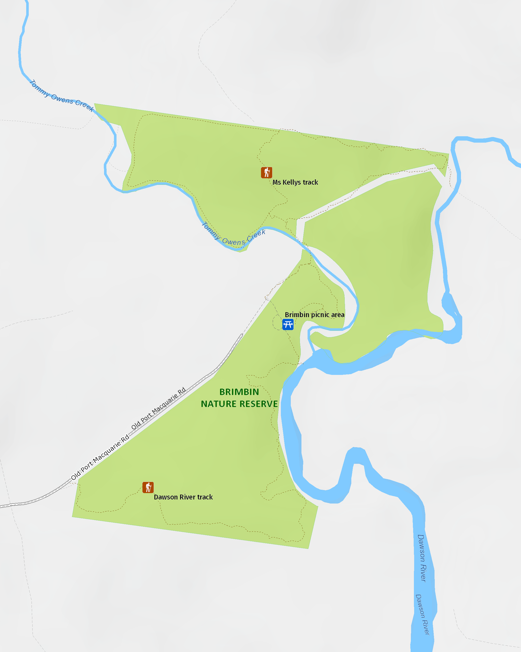
Map legend

Maps and downloads
Nearby towns
Taree (9 km)
Taree is a major mid North Coast city, ringed by superb beaches. It's situated on the Manning River and set against rolling hills.
Wingham (12 km)
A short stroll from the centre of Wingham is Wingham Brush Nature Reserve. Here you'll see a major colony of grey-headed flying foxes hanging head-down in the canopies of 1000-year-old Moreton Bay and strangler figs.
Forster (43 km)
Dominated by water sports Forster is the centre of the Great Lakes area.
Learn more
Brimbin Nature Reserve is a special place. Here are just some of the reasons why:
The Long Paddock

The Travelling Stock Route (TSR) in Australia is an authorised thoroughfare for walking domestic lifestock between locations, and these routes are collectively known as 'The Long Paddock'. Parts of Brimbin were originally the TSR of a stock camp sold in the 1960s. Old Port Macquarie Road, now part of Ms Kellys walking track, follows a section of track established in the 1820s linking Port Macquarie to the Australian Agricultural Co. lands at Stroud and Gloucester. The route allowed bullock-drawn carts to cross Dawson River.
- Dawson River walking track Starting at the Brimbin picnic area near Taree, Dawson River walking track follow the mangrove-lined waterway of Brimbin Nature Reserve, and joins with a historic bullock route.
- Ms Kellys walking track Ms Kellys walking track in Brimbin Nature Reserve is a short walking track near Taree, that follows a historic bullock route and takes in landmarks with names significant to the area’s historic heritage.
Shady grove

The name 'Brimbin' comes from a local Aboriginal word for 'stringybark', which are common to the reserve, as are white mahogany, tallowwood and turpentine. Narrow-leaved red gums provide important food and habitat for koalas. Grey myrtle, swamp oak and water gum can be found along the waterways, with mangroves lining the banks below the tidal limit. River mangrove is usually a bushy shrub, with elongated fruit and clustered white flowers that smell like banana. Its main identifying feature is salt encrustation on its spoon-shaped leaves. Grey mangroves grow, in this area, to around 10m, and have oval pointed leaves, pale green flattened fruit and spongy pencil-like aerial roots spreading from the base of the trunk.
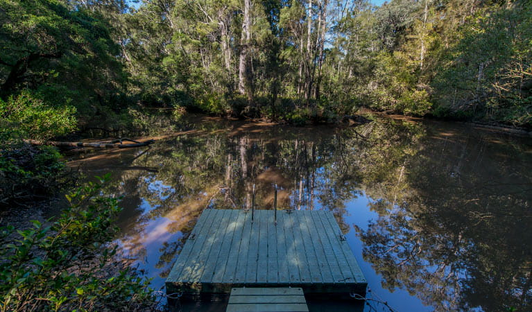
- Brimbin picnic area Not far from Taree, Brimbin picnic area’s idyllic riverside location is a great spot for picnicking, barbecues, canoeing and birdwatching. It’s also where Dawson River walking track begins in Brimbin Nature Reserve.
- Dawson River walking track Starting at the Brimbin picnic area near Taree, Dawson River walking track follow the mangrove-lined waterway of Brimbin Nature Reserve, and joins with a historic bullock route.
Feathering the nest

Manning Valley has over 260 different species of bird, many of which inhabit Brimbin, making it an ideal spot for bird watching. Nests can be seen along waterways. Due to the range of plant communities within the reserve and its proximity to the coast, waterbirds, raptors, woodland and seabirds can be seen at Brimbin. This includes the largest owl on the Australian continent: the powerful owl.
Biripi Aboriginal Nation

When Europeans settled in Manning Valley, the area was occupied by Aboriginal people: the Biripi Nation. This Aboriginal nation is made up of small groups of mostly one or two families, who travelled their country as availability to food sources changed with the seasons. The Biripi harvested native plants, each for a specific use. Identify their food plants, medicinal plants, arts/crafts plants and cultural plants when you visit Brimbin with the help of the Biripi Nation website.
Education resources (1)
What we're doing
Brimbin Nature Reserve has management strategies in place to protect and conserve the values of this park. View the detailed park and fire management documents.