Snowies Alpine Walk: 4 days self guided
Thredbo-Perisher area in Kosciuszko National Park
Overview
Spend 4 days walking in the iconic Snowy Mountains. Use our self guided itinerary to inspire your own Snowies Alpine Walk experience.
![]() 4 days 3+ nights.
4 days 3+ nights.
![]() 56km Grade 4 - Bushwalking experience recommended.
56km Grade 4 - Bushwalking experience recommended.
![]() Travel to and from the walking track each day and stay at National Parks accommodation, campgrounds or find options nearby.
Travel to and from the walking track each day and stay at National Parks accommodation, campgrounds or find options nearby.
![]() National Parks accommodation from $941 for up to 4 people, plus transfers and park entry fees.
National Parks accommodation from $941 for up to 4 people, plus transfers and park entry fees.
![]() Available November to April.
Available November to April.
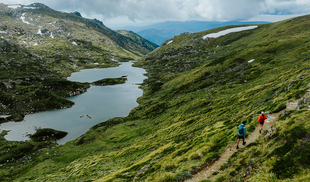
Guthega to Charlotte Pass
9km
Settle into your adventure with a short but scenic hike. Walk to the sound of the snowmelt flowing through the iconic Snowy River with views of the Main Range as your backdrop. You’ll cross Australia’s highest suspension bridge over Spencers Creek.
Main Range
22km
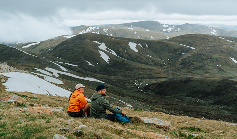
Reach new heights on day 2 as you take on the challenge of Main Range loop. Start by rock hopping across the Snowy River before climbing to see views of Blue Lake. You’ll cross Carruthers Peak and pass Lake Albina before tackling the summit of Australia’s highest mountain. Enjoy panoramic views from the top of Mount Kosciuszko before heading past historic Seamans Hut to finish the loop.

Charlotte Pass Village to Perisher Valley
12.7km
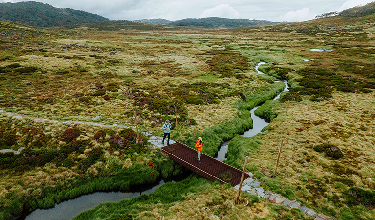
Walk through varied alpine landscapes linking towns at Charlotte Pass Village and Perisher Valley. Along the way, you’ll see expansive views of Thredbo Valley and the giant granite rock boulders at Porcupine Rocks. You'll also walk through sub-alpine areas that are home to summer wildflowers, wombats, and echidnas.

Perisher Valley to Bullocks Flat
12km
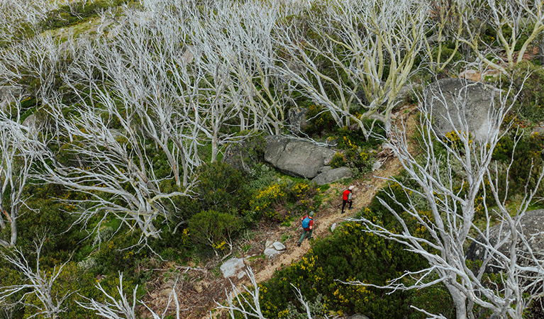
Day 4 is the perfect Snowy Mountains encore with moody alpine ash forests, mossy alpine bogs, and lush woodlands. You'll also see sweeping views of the Monaro Plain and Ramshead Range before finishing your walk along the Thredbo River.

Where to stay

What to book
To complete Snowies Alpine Walk, you'll need 4 days for walking and at least 3 nights to stay. If you need more than half a day to get to Thredbo-Perisher area, consider staying 1 or 2 extra nights to take your time walking the track.
Transfers
There are limited accommodation options along the walk at nearby villages. Walkers will need to book a car or transfer service to get to and from their accommodation and to the track at the start and end of each day. Most days start and end at different spots with very limited parking, so booking your own transfer service when you book accommodation is highly recommended. Book your transfer here.
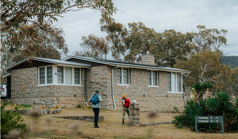
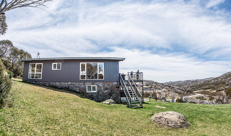
Accommodation
Book NPWS accommodation at Numbananga Lodge or Creel Bay. Numbananga Lodge is located at Smiggin Holes, about 10km from the start of Snowies Alpine Walk and Creel Bay is about 30km away. There is also accommodation near the start and end of each day in nearby villages. You’ll need to book transfers to get to and from your accommodation and the track at the start and end of each day.
Camping
Ngarigo, Thredbo Diggings and Island Bend campgrounds are closest to the walk but there are other NPWS campsites nearby. You’ll need to book campsites and transfers to get to and from the campgrounds and the track at the start and end of each day.
Is this walk right for you
This is a Grade 4 walk in alpine areas that include long steep sections, very steep gradients, and many steps. Some bushwalking experience and a high level of fitness are required. This is because you'll walk between 3 to 9 hours each day carrying a backpack with food, water and safety supplies.
This experience is not wheelchair accessible or suitable for people with reduced mobility.
Safety
Alpine areas present special safety issues so read our alpine safety tips to get prepared. As this is a Grade 4 walk, hiring a personal locator beacon (PLB) and completing a trip intention form is recommended.
Weather in this area can be unpredictable and it can snow in summer. Some sections may be slippery from snow and ice. You'll also need to rock-hop to cross the Snowy River which can be slippery. This crossing may be covered with water and can’t be crossed after rain. Be prepared for all weather by packing warm clothes and sun protection. For more detailed weather information, check out the Bureau of Meteorology website.
Check alerts before you head out for track conditions and closures.
What to bring
This is a 4 day self guided walk. As you'll be staying in a cabin or lodge, you won’t need to carry camping gear. Bring a waterproof backpack that can carry enough water, food and safety gear for a 3 to 9 hour walk each day.
It can snow in alpine areas in summer, so wear layers for changing weather and bring a hat and sunscreen. Wear sturdy walking shoes with good grip and bring waterproof and windproof clothing to keep you warm and dry. Read our bushwalking safety tips to make sure you pack all the essentials and are wearing the right gear.
There are limited options for buying food and snacks year-round along the walk. The nearest town with groceries, cafes and restaurants is Jindabyne where you can visit for a meal or stock up for your stay.
Detailed track notes
Distance: 9km
Time suggested: 3 to 3.5 hours
Toilets at: Guthega Village and Charlotte Pass
Drinking water: Not available
Walk start: Guthega Village
Walk end: Charlotte Pass
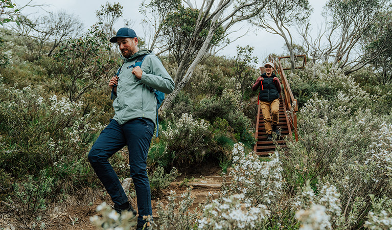
Day 1 is the shortest leg and leaves you with enough time to stop in at Snowy Region Visitor Centre before dropping luggage off at your accommodation. Grab a map, hire a PLB, check alerts or ask staff about track conditions and pay your vehicle entry fee if you're using your own car. Once you’re set, make your way to the start of track at Guthega by car or pre-arranged transfer service. Basecamp Cafe at Guthega Mountain Centre is a good place to grab food at Guthega Village, but it's a good idea to check summer opening hours before you arrive.
Your walk starts with views of Guthega Pondage before following the Snowy River. You’ll feel the instant serenity of nature as you walk to the sound of snowmelt and take in fresh mountain air. Hardy sub-alpine plants surround narrow track sections and raised paths to immerse you in the landscape. In summer, wildflowers like yellow billy buttons and snow daisies add life to the unique muted colour palette of the mountains. Within the first hour, the Main Range will start to pop into view which can be snow-capped even in summer.
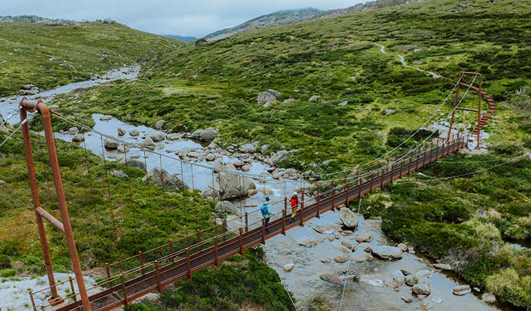
After about 3km, you’ll reach Spencers Creek Suspension Bridge. At 1627m above sea level, it’s Australia’s highest suspension bridge and allows you to cross while peering into the cascading creek from above. Continue to wind your way up for another 5.5km before reaching the end of day 1 at Charlotte Pass. Meet your transfer provider here to travel to your accommodation.
Download a pdf map for day 1 or the map for Thredbo-Perisher area in the NSW National Parks app. Use the app to see where you are on the map as you walk, even when you're offline and have no mobile reception. Check alerts for this section of Snowies Alpine Walk before you go.
Maps
Download the map for Thredbo-Perisher area in the NSW National Parks app before you leave home. Use it to see where you are on the map as you walk, even when you're offline and have no mobile reception.
Getting to Thredbo-Perisher area
Location: Kosciuszko National Park
Gateway towns: Jindabyne
Regional airport: Snowy Mountains Airport, Cooma
Driving distance: 5.5 hours from Sydney, 3 hours from Canberra
Driving directions from Canberra via Jindabyne (park entry fees apply):
- Travel around 100km along the Monaro Highway and through Cooma.
- Continue onto Jindabyne Road following signs for Kosciuszko Road for 60km to Jindabyne.
For Guthega Village : follow Kosciuszko Road through Jindabyne towards Perisher. Turn off onto Guthega Road which is sealed until you reach Guthega power station then continue straight ahead along an unsealed road for around 6.5km to Guthega Village.
For Perisher Village and Charlotte Pass: follow Kosciuszko Road through Jindabyne for 33km to Perisher. Charlotte Pass is 8km beyond Perisher.
For Bullocks Flat: follow Kosciuszko Road through Jindabyne for 3km then turn left onto Alpine Way. Head towards Thredbo Village for about 18km before reaching Bullocks Flat.
Weather and seasons
Spring: Spring is a great time for hiking in the Snowy Mountains. Yellow buttercups are in bloom, rivers run fast with snow melt and the days aren't too hot to explore the country's highest mountains.
Summer: Take advantage of long summer days crystal clear creeks and streams. Blooms of yellow billy buttons, white snow daisies and purple hovea also reach their peak in January. It can get hot but also snow in the mountains in summer so be prepared with appropriate clothing and supplies for all weather.
Autumn: The days are generally dry and crisp and perfect for hiking with a backpack. Be prepared for all weather by packing warm clothes and sun protection.
Winter: Snowies Alpine Walk is covered in snow and not suitable for hiking during the winter months.
For more information
- Snowy Region Visitor Centre
- 8.30am to 5pm daily. Closed Christmas Day.
- 02 6450 5600
- srvc@environment.nsw.gov.au
- 49 Kosciuszko Road, Jindabyne NSW 2627
Fill in a trip intention form

Local alerts
For the latest updates on fires, closures and other alerts in this area, see https://www.nationalparks.nsw.gov.au/things-to-do/walking-tracks/snowies-alpine-walk-4-day/local-alerts
Park info
- in the Thredbo-Perisher area of Kosciuszko National Park in the Snowy Mountains region
- The Thredbo-Perisher area is open all year, but some roads and trails may close due to weather conditions or park management issues. Kosciuszko Road is closed between Perisher and Charlotte Pass in winter (June to October long weekends).
-
Park entry fees apply on Alpine Way and Kosciuszko Road
Winter (June to October long weekends): $29 per vehicle per day (24hrs from purchase); motorcycles $12; bus passengers $11.45 per adult, $3.60 per child per day. Find out more about the winter entry surcharge.
Rest of Year: $17 per vehicle per day (24hrs); motorcycles $7; bus passengers $6.60 per adult, $2.20 per child per day.
Passes: Day passes, multi-day passes and annual All Parks Pass available from NPWS visitor centres, local agents and operating vehicle entry stations. Single and Multi-Day passes are also available via the Park'nPay app. Short Breaks Pass: $68 for 5 days park entry at price of 4 days (not valid winter).
Read our Annual Pass FAQs for information.
Buy annual pass.
Visitor info
All the practical information you need to know about Snowies Alpine Walk: 4 days self guided.
Visitor centre
-
Snowy Region Visitor Centre
49 Kosciuszko Road, Jindabyne NSW 2627 - 8.30am to 5pm daily. Closed Christmas Day.
- 02 6450 5600