Mount Budawang trail
Budawang National Park
Overview
A challenging yet rewarding walk, cutting through several environments; from grassy woodland to montane forest, and finishing at the summit for scenic views.
- Where
- Budawang National Park in South Coast, Country NSW
- Distance
- 8km return
- Time suggested
- 7 - 8hrs
- Grade
- Grade 4
- What to
bring - Drinking water, hat, sunscreen
- Please note
This park is in a remote location and weather can be unpredictable – please ensure you’re well-prepared.
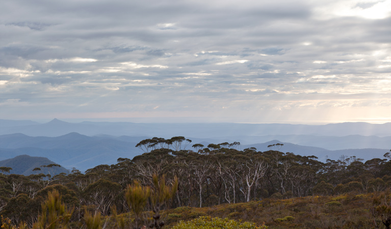
This is bushwalking at its best for those with a keen sense of adventure. Pull on your hiking boots and get ready to sweat, you should be fit and well-prepared with lots of water and a map as this day walk, to the summit of Mount Budawang, is more taxing than its modest distance of 4km suggests.
Threading through a diverse range of environments – grassy woodland, wet gullies, montane forest and grassland at the top – you’re exposed to a terrific cross-section of what makes Budawang National Park wilderness. The rare Budawang wallaby grass, for example, is only found on the summits of Mount Budawang and Currockbilly Mountain.
Bring binoculars for birdwatching, too – crescent honeyeaters and olive whistlers are known to frequent higher areas of the park. The ascent is about 430m up a steep-sided mountain range, but the scenic views from Mount Budawang are tremendous, with 360-degree views of the surrounding area. To the north, along the Budawang Range, are the Castle and Pigeon House Mountain Didthul. To the east are Durras Mountain and the NSW coast. Down below is the forested Clyde River valley, and further afield west you can see all the way to Braidwood’s Mount Gillamatong.
Map
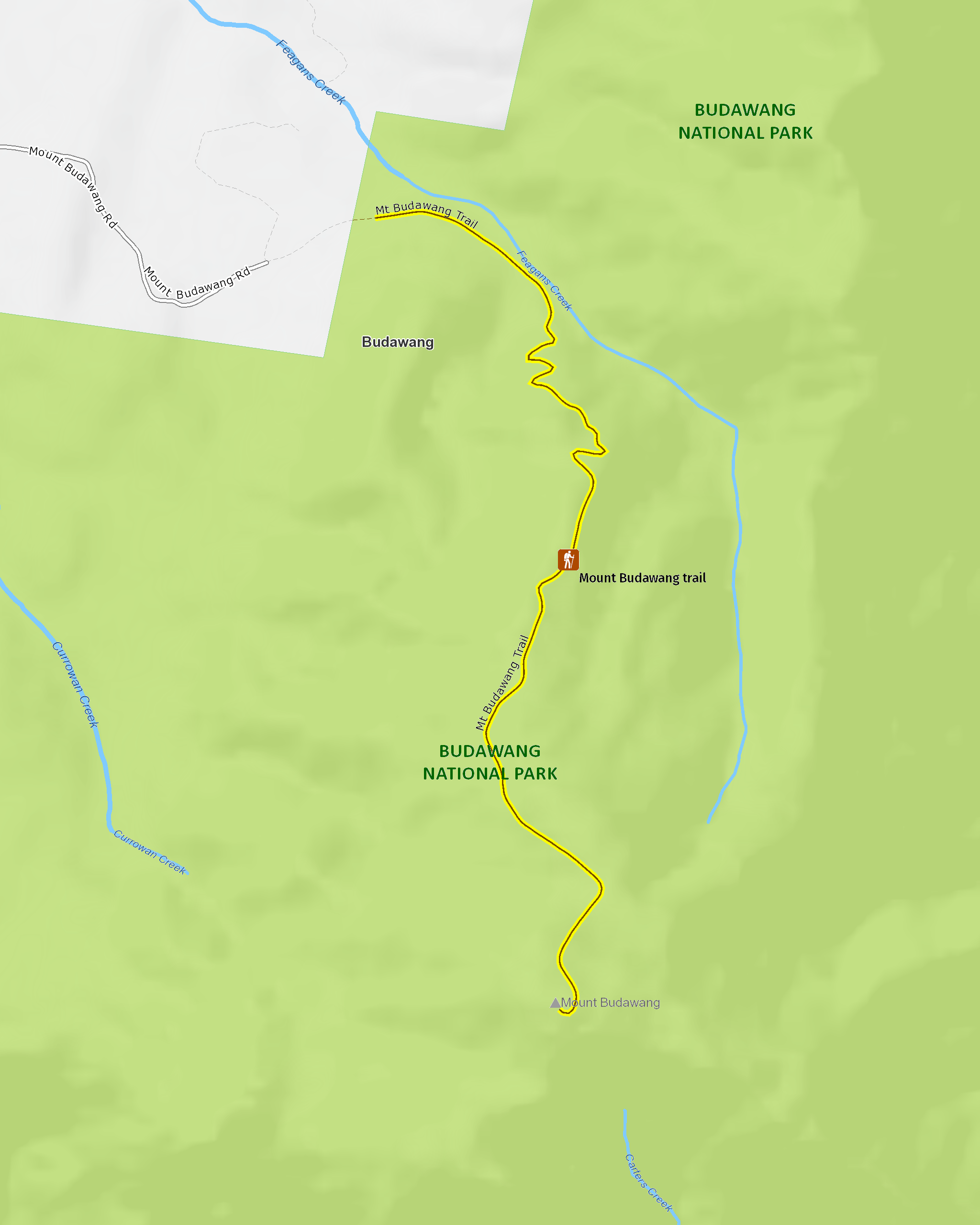
Map legend

Local alerts
For the latest updates on fires, closures and other alerts in this area, see https://www.nationalparks.nsw.gov.au/things-to-do/walking-tracks/mount-budawang-trail/local-alerts
General enquiries
- National Parks Contact Centre
- 7am to 7pm daily
- 1300 072 757 (13000 PARKS) for the cost of a local call within Australia excluding mobiles
- parks.info@environment.nsw.gov.au
Park info
- in Budawang National Park in the South Coast and Country NSW regions
Budawang National Park is always open but may have to close at times due to poor weather or fire danger.
Visitor info
All the practical information you need to know about Mount Budawang trail.
Maps and downloads
Learn more
Mount Budawang trail is in Budawang National Park. Here are just some of the reasons why this park is special:
A natural haven

Budawang National Park supports a wide variety of trees and plants, so budding naturalists will find much of interest here. The eastern slopes of the range contain tall eucalypt forests, temperate rainforest, and several threatened species. There are Budawang ash and pinkwoods as well.
- Long Gully picnic area Long Gully picnic area is a comfortable spot to settle down for the day beside scenic Yadboro River, with nearby swimming and day walks for the experienced hiker.
- Mount Budawang trail A challenging yet rewarding walk, cutting through several environments; from grassy woodland to montane forest, and finishing at the summit for scenic views.
Old stock routes

Once European settlers arrived, early exploration of the area concentrated on finding routes across the rugged escarpment country to link the tablelands and coast. Many of the ancient Aboriginal pathways became an important part of the early bridle trail network used for movement of stock. One of these was Wog Wog track, which was used to move cattle from Braidwood to the coast.
Rare plant refuge

High up, on the summits of Mount Budawang and Currockbilly Mountain, you'll find the last refuge of the critically endangered Budawang wallaby grass. This rare plant doesn't grow anywhere else in the world, and has been declared an Asset of Intergenerational Significance, giving it extra legal protections. With such a small population remaining in the wild, this threatened grass species is at risk from catastrophic fire events and, in particular, human disturbance. Help us secure this native species for future generations by cleaning your walking shoes before you visit to avoid introducing invasive weeds and pathogens like deadly Phytophthora cinnamomi, and stay on tracks to avoid trampling seedlings, damaging exposed roots and fragile soils.
Volcanic foundations

Southern Budawang Range is formed on Devonian sediments that were uplifted to form the Budawang Synclinorium. Volcanic rock on the slopes slowly transforms into fertile soil that supports the varied ecosystems of tall moist forest and rainforest. The altitude range in the park is more than 800 metres, though two peaks in the park - Mount Budawang and Currockbilly Mountain - rise to over 1,100m above sea level.
- Mount Budawang trail A challenging yet rewarding walk, cutting through several environments; from grassy woodland to montane forest, and finishing at the summit for scenic views.