Jilliby State Conservation Area
Overview
Located near Central Coast, Jilliby State Conservation Area is a popular place for 4WD touring, mountain biking, horse riding and long bush walks through the forest.
Read more about Jilliby State Conservation Area
Jilliby State Conservation Area allows you to escape into a natural haven, with the advantage of being so close to Central Coast. The park is also an idyllic spot for horse riding, mountain biking, walking and adventures in your 4WD.
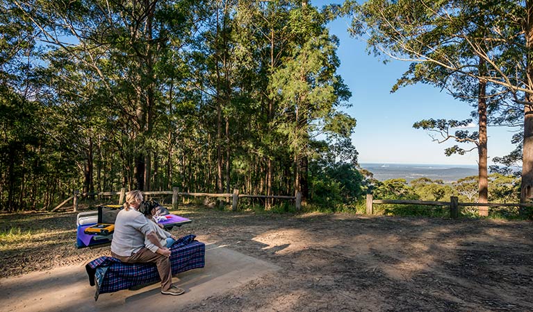
Explore many of the trails throughout the landscape and when you feel like a rest, set up a picnic at any of the two picturesque picnic areas located at Muirs lookout or Stoney Ridge. From Muirs lookout, scenic views stretch out to Lake Macquarie and Lake Munmorah, with a glimpse of the coastline and Bird Island in the far distance.
Birdwatching is a treat in Jilliby as there are over 130 recorded species in Watagan Range. However, if you prefer bushwalking, then keep your eyes peeled for the local wildlife. There have been over 150 native animals recorded in the area, including endangered animals like the yellow-bellied glider and the yellow-bellied sheath-tail bat.
Local alerts
For the latest updates on fires, closures and other alerts in this area, see https://www.nationalparks.nsw.gov.au/visit-a-park/parks/jilliby-state-conservation-area/local-alerts
Contact
- in the Sydney and surrounds and North Coast regions
Jilliby State Conservation Area is always open but some sections may have to close at times due to poor weather or fire danger.
-
-
Lake Munmorah office
02 4972 9000
Contact hours: Monday to Friday, 8.30am to 4pm. - 1 Blue Wren Drive, Wybung NSW 2259
-
Email: npws.centralcoast@environment.nsw.gov.au
-
Lake Munmorah office
-
-
Girrakool office
02 4320 4200
Contact hours: Monday to Friday, hours vary. - 59 Girrakool Rd, Somersby, NSW 2250
-
Email: npws.centralcoast@environment.nsw.gov.au
-
Girrakool office
Visitor info
All the practical information you need to know about Jilliby State Conservation Area.
Map

Map legend

Maps and downloads
Nearby towns
Wyong (11 km)
Wyong is a bustling township and the centre for Wyong Shire. There's something for everyone, as it's close to the Central Coast's lakes, beaches and wooded valleys.
Morisset (15 km)
Morisset is a gateway to the Watagan Mountains. It's a resort and residential town close to huge state forest. It's situated on Lake Macquarie between water and woodlands.
Gosford (31 km)
Gosford is a great destination for a family day trip or holiday. It's situated on Brisbane Water National Park and surrounded by state forests, lakes and beaches.
Learn more
Jilliby State Conservation Area is a special place. Here are just some of the reasons why:
Unique plants and animals

Jilliby is a natural wonderland filled with an enormous diversity of plant species and native vegetation. Wandering through, you'll discover tall moist eucalypt forests flourishing with mountain blue gum and blue-leaved stringybark. There are also drier forest areas that will enchant you with forest oak, Sydney peppermint, and broad-leaved white mahogany. Pockets of paperbark palm forests, and warm-temperate as well as subtropical rainforest occur in sheltered gullies and creeklines.
- Muirs lookout Muirs lookout at Jilliby State Conservation Area displays amazing scenic views from the Watagan Range overlooking neighbouring townships.
Aboriginal sites

Jilliby is an important cultural and historical area for Aboriginal people. There are more than 40 recorded Aboriginal sites in Jilliby, and the adjacent Watagans National Park also includes art sites, axe-grinding grooves and open campsites. Awabakal and Darkinjung People were the original inhabitants of Watagan Range, which once provided a rich range of food sources, including plant foods such as fruit, acacia, grass seeds and nectar. Fish and freshwater shellfish were fished from the rivers, and local wallabies, kangaroos, possums, lizards and even insects were all part of the local diet.
A history of booming trade

The mountainous ranges and heavily timbered gullies of Watagan Range were a physical barrier to exploration and development. Jilliby was on the western side of Tuggerah Lakes and Lake Munmorah as the colony of Sydney began to expand. These ranges soon were exploited to provide valuable, marketable timber using nearby waterways for transport. Government licences were issued to a small number of sawyers to cut red cedar in the ranges west of Tuggerah and Lake Macquarie. The early colonial cedar trade saw most of the cedar shipped off to England to supply an insatiable market for fine softwoods. Hardwood fed a building boom from the 1860s and provided sleepers for the northern railway line.
Education resources (1)
What we're doing
Jilliby State Conservation Area has management strategies in place to protect and conserve the values of this park. View the detailed park and fire management documents.