Overview
Ms Kellys walking track in Brimbin Nature Reserve is a short walking track near Taree, that follows a historic bullock route and takes in landmarks with names significant to the area’s historic heritage.
- Where
- Brimbin Nature Reserve in North Coast
- Accessibility
- Hard
- Distance
- 1.5km loop
- Time suggested
- 45min - 1hr 15min
- Grade
- Grade 3
- What to
bring - Hat, sunscreen, drinking water
- Please note
- The weather in the area can be extreme and unpredictable, so please ensure you’re well-prepared for your visit.
- Remember to take your binoculars if you want to birdwatch.
Isabella Mary Kelly, New South Wales’ only independent female colonial settler, was a wealthy Irish woman who sailed into Sydney Harbour in 1834 looking for a tree change. She bought up Crown Land and ran her own station. Isabella was apparently disliked by her neighbours for doing ‘men’s work’, her house burnt down in her absence and she was, for a time, unjustly imprisoned after subletting to a conman. History has painted her character in various extremes, from a gun-slinging tyrant to a brave pioneering hero.
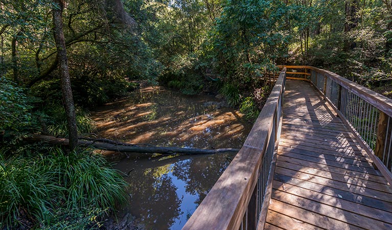
Beginning at Tommy Owens Crossing, the track passes through a dense area of swamp oak then, from Ms Kellys Crossing, follows part of Old Port Macquarie Road. From the late 1820s, this historic route allowed bullock-drawn vehicles to cross Dawson River and continue on to Port Macquarie.
It’s a great trail for walking with children. See how many different birds they can spot along the way.
Map

Map legend

Local alerts
For the latest updates on fires, closures and other alerts in this area, see https://www.nationalparks.nsw.gov.au/things-to-do/walking-tracks/ms-kellys-walking-track/local-alerts
General enquiries
- National Parks Contact Centre
- 7am to 7pm daily
- 1300 072 757 (13000 PARKS) for the cost of a local call within Australia excluding mobiles
- parks.info@environment.nsw.gov.au
Park info
- in Brimbin Nature Reserve in the North Coast region
Brimbin Nature Reserve is always open but may have to close at times due to flood events, poor weather or fire danger.
Visitor info
All the practical information you need to know about Ms Kellys walking track.
Track grading
Features of this track
Distance
1.5km loop
Time
45min - 1hr 15min
Quality of markings
Clearly sign posted
Experience required
No experience required
Steps
No steps
Gradient
Gentle hills: The track has gentle hills and can be undulating in parts.
Quality of path
Formed track, some obstacles: The track is hard-packed ground and around 1m wide. There are points along the track where it narrows.
Other barriers
Other barriers: You can reach the Dawson River pontoon from the walking track. There's a ramp at the pontoon, but it's made to fall rise and fall with the river level and be quite steep.
There's a wooden walkway to the pontoon with handrails, but no further handrails once you reach the pontoon. The pontoon can be slippery when wet.
Getting there and parking
On entering Brimbin Nature Reserve, follow the signs to the walking track from the carpark.
Parking
There's a gravel carpark with 2 accessible parking spaces at Brimbin picnic area where this walk begins. It can be a busy place on the weekend, so parking may be limited.
Best times to visit
There are lots of great things waiting for you in Brimbin Nature Reserve. Here are some of the highlights.
Winter
Keep a close eye out for the flowering fairy light (or helmet) orchid in the forest leaf litter. It's a sparkling white flower with pinkish edges that grows on a short stem.
Weather, temperature and rainfall
Summer temperature
Average
17.2°C and 28.6°C
Highest recorded
45.2°C
Winter temperature
Average
6.5°C and 19.1°C
Lowest recorded
-5°C
Rainfall
Wettest month
March
Driest month
September
The area’s highest recorded rainfall in one day
280.2mm
Facilities
Drinking water is limited or not available in this area, so it’s a good idea to bring your own.
There are accessible toilets, barbecues and picnic tables at Brimbin picnic area, where this walk begins.
Maps and downloads
Accessibility
Disability access level - hard
- The walking track is 1m wide and hard-packed ground along its length.
- There are no steps along the track, but there are points where it narrows and it can be rough and undulating.
- Access to Dawson River pontoon (near the start of the walk) is via a ramp that rises and falls with the river and can be steep. There no handrails on this ramp and it can be slippery when wet.
Permitted
Fishing
A current NSW recreational fishing licence is required when fishing in all waters.
Prohibited
Pets
Pets and domestic animals (other than certified assistance animals) are not permitted. Find out which regional parks allow dog walking and see the pets in parks policy for more information.
Smoking
NSW national parks are no smoking areas.
Learn more
Ms Kellys walking track is in Brimbin Nature Reserve. Here are just some of the reasons why this park is special:
Biripi Aboriginal Nation

When Europeans settled in Manning Valley, the area was occupied by Aboriginal people: the Biripi Nation. This Aboriginal nation is made up of small groups of mostly one or two families, who travelled their country as availability to food sources changed with the seasons. The Biripi harvested native plants, each for a specific use. Identify their food plants, medicinal plants, arts/crafts plants and cultural plants when you visit Brimbin with the help of the Biripi Nation website.
Feathering the nest

Manning Valley has over 260 different species of bird, many of which inhabit Brimbin, making it an ideal spot for bird watching. Nests can be seen along waterways. Due to the range of plant communities within the reserve and its proximity to the coast, waterbirds, raptors, woodland and seabirds can be seen at Brimbin. This includes the largest owl on the Australian continent: the powerful owl.
Shady grove

The name 'Brimbin' comes from a local Aboriginal word for 'stringybark', which are common to the reserve, as are white mahogany, tallowwood and turpentine. Narrow-leaved red gums provide important food and habitat for koalas. Grey myrtle, swamp oak and water gum can be found along the waterways, with mangroves lining the banks below the tidal limit. River mangrove is usually a bushy shrub, with elongated fruit and clustered white flowers that smell like banana. Its main identifying feature is salt encrustation on its spoon-shaped leaves. Grey mangroves grow, in this area, to around 10m, and have oval pointed leaves, pale green flattened fruit and spongy pencil-like aerial roots spreading from the base of the trunk.
- Brimbin picnic area Not far from Taree, Brimbin picnic area’s idyllic riverside location is a great spot for picnicking, barbecues, canoeing and birdwatching. It’s also where Dawson River walking track begins in Brimbin Nature Reserve.
- Dawson River walking track Starting at the Brimbin picnic area near Taree, Dawson River walking track follow the mangrove-lined waterway of Brimbin Nature Reserve, and joins with a historic bullock route.
The Long Paddock

The Travelling Stock Route (TSR) in Australia is an authorised thoroughfare for walking domestic lifestock between locations, and these routes are collectively known as 'The Long Paddock'. Parts of Brimbin were originally the TSR of a stock camp sold in the 1960s. Old Port Macquarie Road, now part of Ms Kellys walking track, follows a section of track established in the 1820s linking Port Macquarie to the Australian Agricultural Co. lands at Stroud and Gloucester. The route allowed bullock-drawn carts to cross Dawson River.
- Dawson River walking track Starting at the Brimbin picnic area near Taree, Dawson River walking track follow the mangrove-lined waterway of Brimbin Nature Reserve, and joins with a historic bullock route.
- Ms Kellys walking track Ms Kellys walking track in Brimbin Nature Reserve is a short walking track near Taree, that follows a historic bullock route and takes in landmarks with names significant to the area’s historic heritage.