Overview
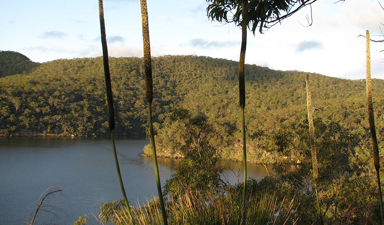
Coba Ridge to Collingridge Point walking track is a pleasant day walk or mountain bike ride through Marramarra National Park, near Hornsby. It offers wonderful spring wildflowers and stunning views of Berowra Creek.
- Accessibility
- No wheelchair access
- Distance
- 10km return
- Time suggested
- 3 - 4hrs
- Grade
- Grade 3
- What to
bring - Hat, sunscreen, raincoat, snacks, drinking water, sturdy shoes, suitable clothing
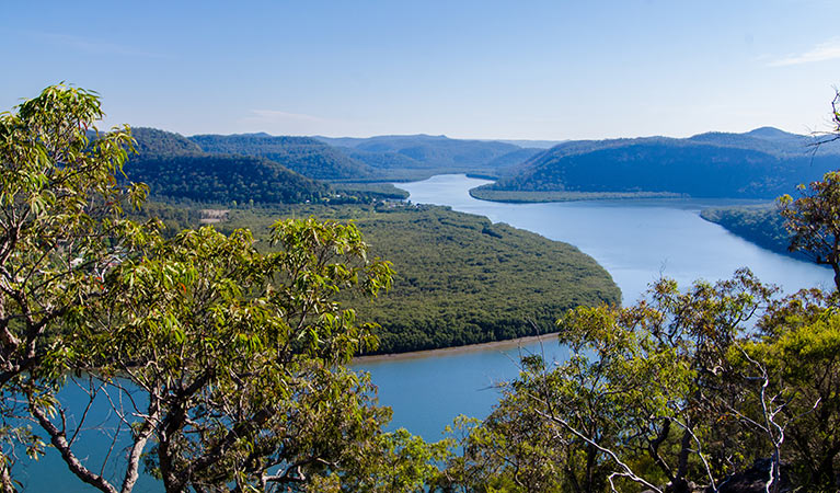
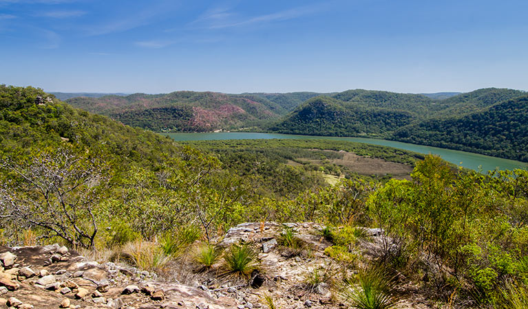
If you’re looking for a nature walk that’s close to home but feels a million miles away, head to Marramarra National Park in north-west Sydney. Here, you’ll find Coba Ridge to Collingridge Point walking track. This mostly flat option treats you to beautiful views of the surrounding valleys and the calm waters of Berowra Creek on your way to Collingridge Point.
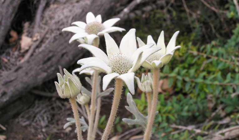
The track is popular with families, mountain bikers and wildflower enthusiasts – visit in spring to see the landscape burst with colour. You’ll see pink and purple boronias, soft yellow spike wattles, tall flowering grass trees, and bouquets of white on the long leaf smokebush.
The walking track starts at the end of Bloodwood Road and follows Coba Ridge fire trail for 4km. When you reach the junction, keep right and follow the track south for another 1km. You’ll reach an unfenced sandstone outcrop, with stunning views overlooking Collingridge Point and Berowra Creek.
For an extended, 20km return walk, at the junction stay left to continue another 6km to Coba Point. Or, if you’re keen to explore more, try the Marramarra Ridge to Smugglers Ridge walking track and combine it with a stay at Marramarra Creek campground. After a day of hiking, you can cool off in the river and enjoy an authentic bush camping experience.
Map
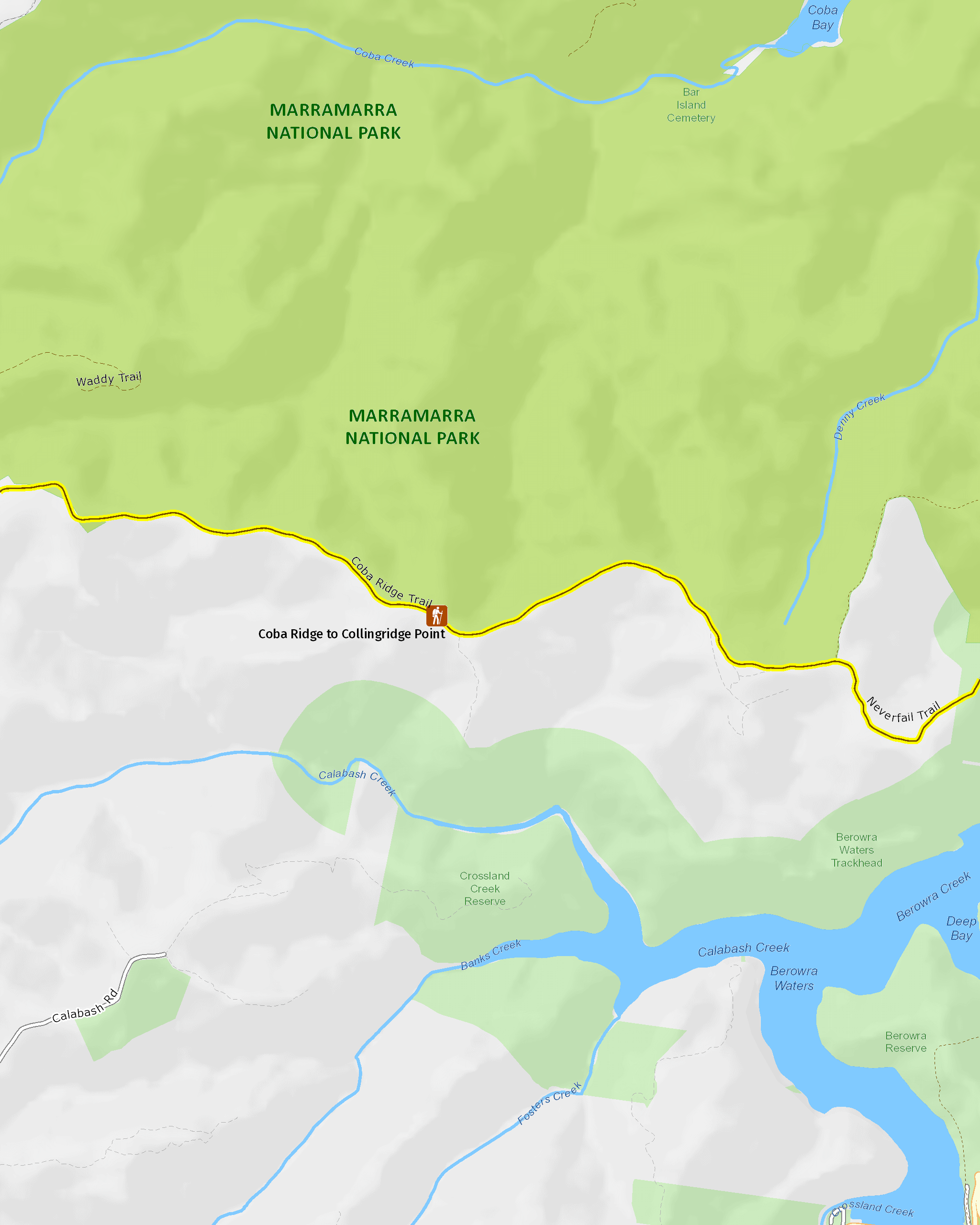
Map legend

Local alerts
For the latest updates on fires, closures and other alerts in this area, see https://www.nationalparks.nsw.gov.au/things-to-do/walking-tracks/coba-ridge-to-collingridge-point-walking-track/local-alerts
General enquiries
- National Parks Contact Centre
- 7am to 7pm daily
- 1300 072 757 (13000 PARKS) for the cost of a local call within Australia excluding mobiles
- parks.info@environment.nsw.gov.au
Park info
- in Marramarra National Park in the Sydney and surrounds region
Marramarra National Park is always open but may have to close at times due to poor weather or fire danger.
Visitor info
All the practical information you need to know about Coba Ridge to Collingridge Point walking track.
Track grading
Features of this track
Distance
10km return
Time
3 - 4hrs
Quality of markings
Clearly sign posted
Experience required
Some bushwalking experience recommended
Gradient
Gentle hills
Steps
Occasional steps
Quality of path
Formed track
Getting there and parking
Coba Ridge to Collingridge Point walking track is in the southern area of Marramarra National Park. To get there:
From Hornsby:
- Follow Galston Road through Galston Gorge
- Turn right onto Arcadia Road, then after 4km turn left onto Cobah Road
- Continue straight along Bloodwood Road until the end of the road
- The walking track starts at the gate where Coba Ridge fire trail begins.
From Wisemans Ferry:
- Drive south on Old Northern Road towards Dural
- After 34km, turn left onto Wylds Road and continue for 1.6km
- Turn left onto Arcadia Road and continue for 800m
- Turn left onto Cobah Road and follow around multiple corners
- Continue straight onto Bloodwood Road until the end of the road
- The walking track starts at the gate where Coba Ridge fire trail begins.
Road quality
- Sealed roads
Vehicle access
- 2WD vehicles (no long vehicle access)
Weather restrictions
- All weather
Parking
Limited parking is available at the end of Bloodwood Road, where the walking track begins.
Facilities
- There are no bins available, so you’ll need to take all rubbish away with you.
- There is no drinking water available, so please bring enough for your visit.
- The nearest public toilets are located at Galston Shopping Centre on Galston Road, or Fagan Park on Arcadia Road.
Maps and downloads
Accessibility
Disability access level - no wheelchair access
Permitted
Cycling
Prohibited
Gathering firewood
Pets
Pets and domestic animals (other than certified assistance animals) are not permitted. Find out which regional parks allow dog walking and see the pets in parks policy for more information.
Smoking
NSW national parks are no smoking areas.
Learn more
Coba Ridge to Collingridge Point walking track is in Marramarra National Park. Here are just some of the reasons why this park is special:
Darug country
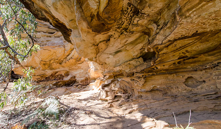
Marramarra is part of the traditional lands of the Darug Aboriginal people. Their use and respect of the land can be found in isolated corners of the park. The surviving Aboriginal sites, which provide the only indications of traditional life in the area, are of special importance to local Aboriginal communities. Cave art, rock engravings, grinding grooves, middens, scarred trees, and other occupational deposits and stone arrangements are all part of Marramarra.
Exploring the land
In the early days of the new colony, Hawkesbury River was a major communication route and supported an active river-based community. European exploration began as early as 1789 when Governor Arthur Phillip took his second trip up Hawkesbury River and camped at Gentlemans Halt. By 1884, there was a small community at Gentlemans Halt and a provisional school had been established; you can still see the foundations of a road and a wharf from this era. Other reminders of European historic heritage include remains of orange orchards along Marramarra Creek and the foundations of a hut, stone walls and a well at Big Bay.
Is it a bird?
Marramarra is home to a great diversity of animals and birds, making it a great place for wildlife spotting and bird watching. You're likely to spot a white-breasted sea eagle, swamp wallaby, possum or kingfisher in your travels. If you're lucky, you might come across some of the more uncommon animals found here such as rails, gang-gang and glossy black cockatoos, and red-crowned toadlets.
- Canoelands Ridge walking track Canoelands Ridge walking track is a beautiful day walk near Hornsby and Sydney. See scenic Hawkesbury River views and native wildflowers along the way on this long hike.
- Marramarra Ridge to Smugglers Ridge walking track Discover the beauty of Marramarra, near Hornsby, on this day walk. Enjoy scenic views, historic heritage, colourful wildflowers and picnicking along the way.
Plentiful lands
The sandstone ridges and deep gullies of Marramarra support a wide range of environments. Experience salt marsh and mangrove forests on the shores of Hawkesbury River, to tall open forest and ridge-top woodlands. In spring, the bush turns into a brilliant display of colour as the wildflowers burst in action. Discover the unique plant life and help preserve it – why not participate in the bush regeneration volunteer programs in the park?
- Canoelands Ridge walking track Canoelands Ridge walking track is a beautiful day walk near Hornsby and Sydney. See scenic Hawkesbury River views and native wildflowers along the way on this long hike.
- Marramarra adventurous journeys with YouthAdvance Fuel your sense of adventure on an exciting trip with YouthAdvance. You’ll learn navigation, teamwork and campcraft in beautiful Marramarra National Park, near Sydney.
- Marramarra Ridge to Smugglers Ridge walking track Discover the beauty of Marramarra, near Hornsby, on this day walk. Enjoy scenic views, historic heritage, colourful wildflowers and picnicking along the way.