Yerranderie Private Town
Yerranderie Regional Park
Overview
At this early mining settlement you can explore a NSW ghost town that’s been lovingly preserved, with many relics remaining. It’s also a great area to go 4WD touring.
- Type
- Historic buildings/places
- Accessibility
- Hard
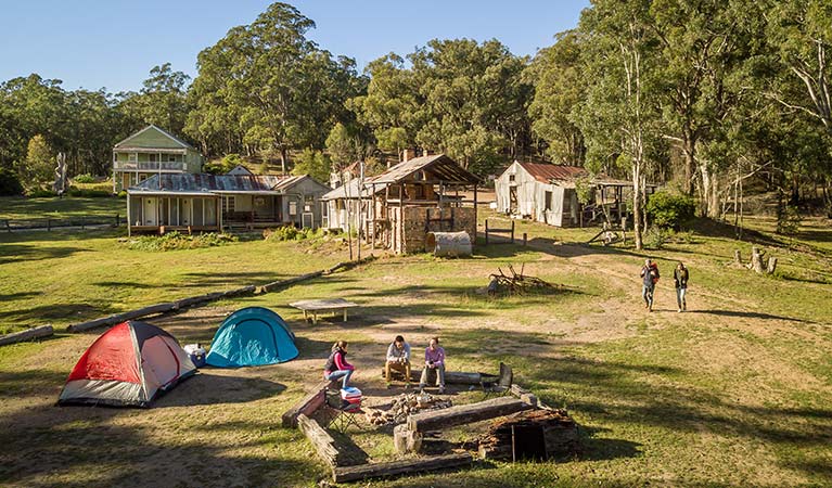
Yerranderie Private Town is one of NSW’s most authentic, unchanged silver mining ghost towns, having been carefully preserved to retain its historic past. Accessed via 4WD Oberon Colong historic stock route, the buildings, including the post office, tailor shop, general store, bank and residential cottages, have been restored to their original condition as accurately as possible, and the displays are all of genuine relics collected by miners over the decades.
Take a tour of the nearby silver mining fields, the most prominent of which are Silver Peak Mine, Colon Peak Mine, Wonga Mine and Wollondilly Mine. A bridge has been installed across the top of one of the large mineshafts on Silver Peak Mine, so you can gaze right down into the mine.
It’s also a great spot to see interesting wildlife, as the township is set in a large sanctuary with mobs of grey kangaroos, wombats, wallabies, walleroos and mountain birds in natural bushland. Stay overnight at Private Town campground and enjoy scenic bushwalking in the adjacent wilderness area.
Take a virtual tour of Yerranderie Private Town captured with Google Street View Trekker.
Also see
-

Government Town campground
Stay the night at Government Town campground near Yerranderie Regional Park. With unmarked sites for tents and camper trailers, you'll be moments away from the fascinating history of a forgotten silver mine ghost town.
Map

Map legend

Local alerts
For the latest updates on fires, closures and other alerts in this area, see https://www.nationalparks.nsw.gov.au/things-to-do/historic-buildings-places/yerranderie-private-town/local-alerts
General enquiries
- National Parks Contact Centre
- 7am to 7pm daily
- 1300 072 757 (13000 PARKS) for the cost of a local call within Australia excluding mobiles
- parks.info@environment.nsw.gov.au
Park info
- in Yerranderie Regional Park in the Sydney and surrounds region
Yerranderie Regional Park is always open but may have to close at times due to poor weather or fire danger.
Visitor info
All the practical information you need to know about Yerranderie Private Town.
Maps and downloads
Learn more
Yerranderie Private Town is in Yerranderie Regional Park. Here are just some of the reasons why this park is special:
Mining heritage

Yerranderie township has retained much evidence of its history as a mining settlement of the early 20th century through its various remains, sites, mines, architecture and ruins. These, in combination with remnant exotic plantings, road systems and subdivision patterns, bring its early settlement to life for visitors. Yerranderie appears to be the only 20th century mining site to be preserved quasi-intact in all of eastern NSW and is an exceptionally well-preserved archaeological site. The township has been lovingly preserved to reflect its history, but the land itself has not seen much subsequent development due to its isolation. An unusually rich assemblage of mining equipment can still be viewed in the mines, and the township has a varied selection of sites, remains, ruins and buildings.
- 4WD Oberon Colong historic stock route Intrepid 4WD tourers will love the 4WD Oberon Colong historic route. Travel through the wild south of Blue Mountains National Park to a historic mining ghost town in Yerranderie Regional Park.
Dramatic natural environment

Yerranderie lies at the centre of a broad visual catchment surrounded by sandstone escarpments and indigenous bushland. The combination of this spectacular natural setting, strong sense of isolation, and the remnants of mining and settlement activity of the past all contribute to give the township a powerful identity and sense of place.
Education resources (1)
General enquiries
- National Parks Contact Centre
- 7am to 7pm daily
- 1300 072 757 (13000 PARKS) for the cost of a local call within Australia excluding mobiles
- parks.info@environment.nsw.gov.au
Operated by
- Oberon office
- Monday to Friday, 9am to 4.30pm.
- 02 6336 6200
- npws.kanangra@environment.nsw.gov.au
- 38 Ross Street, Oberon NSW 2787
Park info
- in Yerranderie Regional Park in the Sydney and surrounds region
Yerranderie Regional Park is always open but may have to close at times due to poor weather or fire danger.
What's nearby:
Things to do (57)
- 4WD touring (2)
- Aboriginal culture (2)
- Birdwatching and wildlife encounters (12)
- Cafes and kiosks (1)
- Cycling (3)
- Environmental appreciation/study (1)
- Historic heritage (3)
- Other experiences (7)
- Photography (2)
- Picnics and barbecues (5)
- Road trips and car/bus tours (1)
- Show cave tours (7)
- Sightseeing (20)
- Swimming (1)
- Walking (18)
- Waterfalls (6)