Wollumbin National Park
Overview
Wollumbin (Mount Warning) summit track and Aboriginal Place remains closed. Decisions about the future of the summit track will be made by the NSW National Parks and Wildlife Service in accordance with the wishes of Aboriginal custodians.
Read more about Wollumbin National Park
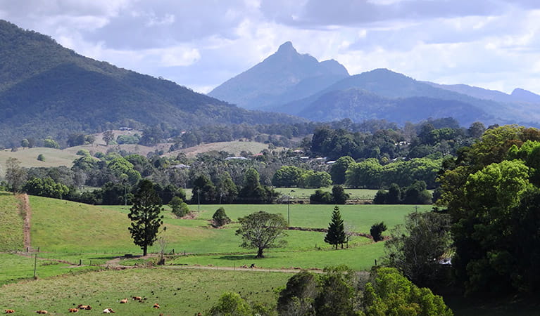
Wollumbin, which rises from World Heritage-listed Wollumbin National Park to a height of 1,157 metres above sea level, is a remnant central vent of an ancient volcano. Formerly known as Mount Warning, this spectacular peak can be viewed from a range of vantage points in the surrounding massive crater (caldera), including Cudgen Nature Reserve, Border Ranges National Park, Nightcap National Park and Cape Byron Lighthouse. Wollumbin is highly significant to Aboriginal people, particularly the Bundjalung nation, as a place of sacred ceremonies linked to traditional law and custom.
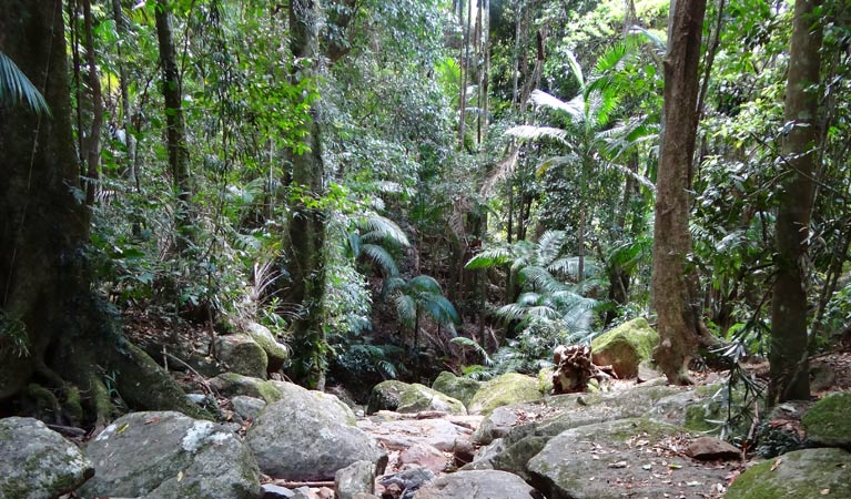
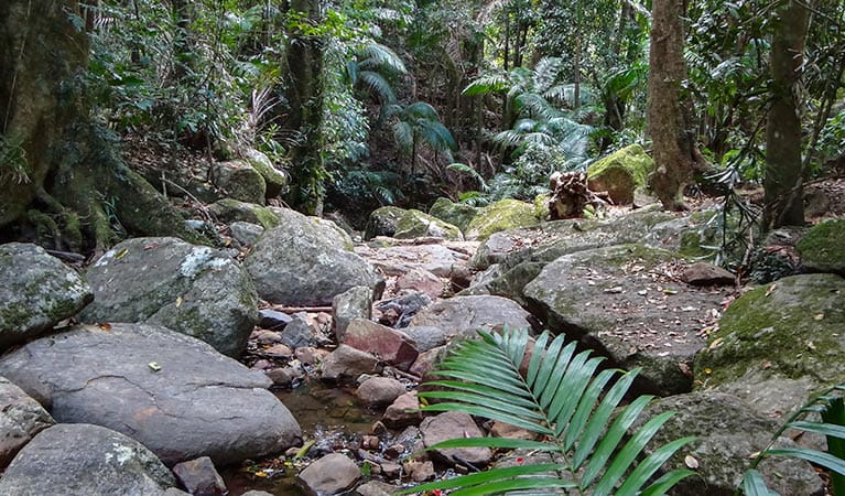
Wollumbin National Park is great for family visits. Head off on Lyrebird track for a short walk through the lush rainforest, then stay at Breakfast Creek or make your way to Korrumbyn Creek picnic area for lunch.
View the Environment and Heritage webpage for an update on management of the park.
Local alerts
For the latest updates on fires, closures and other alerts in this area, see https://www.nationalparks.nsw.gov.au/visit-a-park/parks/wollumbin-national-park/local-alerts
Contact
- in the North Coast region
Wollumbin National Park is open, but may have to close at times due to perceived risk. The gate on Mount Warning Road entrance may also be closed from 5pm in winter and 6pm in summer (during daylight savings) and will reopen at 7am the following morning.
-
-
Murwillumbah office
-
Email: npws.tweedbyron@environment.nsw.gov.au
-
Murwillumbah office
Visitor info
All the practical information you need to know about Wollumbin National Park.
Getting there and parking
From Murwillumbah:
- Head southwest towards Uki along Riverview Street, which becomes Kyogle Road, and then Uki Road at Byangum Bridge.
- Approximately 12km from Murwillumbah, before you reach Uki, turn right into Mount Warning Road.
- Travel approximately 3.5km to carpark
Parking
The gate on Mount Warning Road entrance to the carpark at Breakfast Creek may be closed from 5pm in winter and 6pm in summer (during daylight savings) and will reopen at 7am the following morning.
By bike
Check out the Bicycle information for NSW website for more information.
By public transport
For information about public transport options, visit the NSW country transport info website.
Best times to visit
There are lots of great things waiting for you in Wollumbin National Park. Here are some of the highlights.
Autumn
Look out for macropods and young birds as they prepare to head out by themselves and find their own home range.
Spring
During this season, the forest floor comes alive with colour and activity while the canopy blooms with flowers and bears fruit above. Birds display their breeding plumage while animals taking advantage of the free bounty. The sweet fragrance of nectar fills the forest to entice insects, birds, bats and mammals.
Summer
The frequency of spectacular afternoon storms means this can be a great time for photographers.
Winter
Enjoy the clear blue skies common during this season of stable highs which dominate the Northern Rivers region in winter.
Weather, temperature and rainfall
Summer temperature
Average
19°C and 28°C
Highest recorded
43°C
Winter temperature
Average
9°C and 21.5°C
Lowest recorded
-0.3°C
Rainfall
Wettest month
February
Driest month
September
The area’s highest recorded rainfall in one day
321mm
Maps and downloads
Prohibited
Pets
Pets and domestic animals (other than certified assistance animals) are not permitted. Find out which regional parks allow dog walking and see the pets in parks policy for more information.
Smoking
NSW national parks are no smoking areas.
Nearby towns
Uki (10 km)
Explore the scenic wonders of the lush, World Heritage-listed rainforests of northern NSW on the meandering Rainforest Way. Uki is just one of the small villages that you'll pass through - it's certainly in one of the most scenic locations.
Murwillumbah (15 km)
Murwillumbah is rich dairy, sugar cane and banana country. It's located on the banks of the Tweed River and set in the Tweed River Valley against a backdrop of rainforest-clad hills.
Mullumbimby (55 km)
Mullumbimby sits on the Brunswick River and is overshadowed by subtropical hills.
Learn more
Wollumbin National Park is a special place. Here are just some of the reasons why:
Sacred summit
Captain Cook named it Mount Warning, but to the Aboriginal community it's a sacred place known as Wollumbin. The Wollumbin summit was declared an Aboriginal Place by the NSW Government in 2014, formally recognising the cultural connection of this place to Aboriginal people. Wollumbin is of great significance to many Aboriginal communities across Australia, particularly the Bundjalung and Githabul Nations. The Traditional Custodians and Aboriginal communities associated with Wollumbin continue to care for and manage Country, as well as their sacred spiritual sites and places.
- Wollumbin (Mount Warning) summit track Wollumbin (Mount Warning) summit track and Aboriginal Place remains closed. Decisions about the future of the summit track will be made by the NSW National Parks and Wildlife Service in accordance with the wishes of Aboriginal custodians.
Green rooms of the world
Wollumbin National Park is a Gondwana Rainforest of Australia. Gondwana rainforests include the world's most extensive areas of subtropical rainforest, large areas of warm temperate rainforest and Antarctic beech cool temperate rainforest. Luckily, you don't have to go far to experience some of these environments, which are practically in your backyard.
- Lyrebird track Lyrebird track is a short walk in Wollumbin National Park. It leads from Mount Warning Road across Breakfast Creek to a lookout surrounded by rainforest.
- Wollumbin (Mount Warning) summit track Wollumbin (Mount Warning) summit track and Aboriginal Place remains closed. Decisions about the future of the summit track will be made by the NSW National Parks and Wildlife Service in accordance with the wishes of Aboriginal custodians.
Voices of the forest
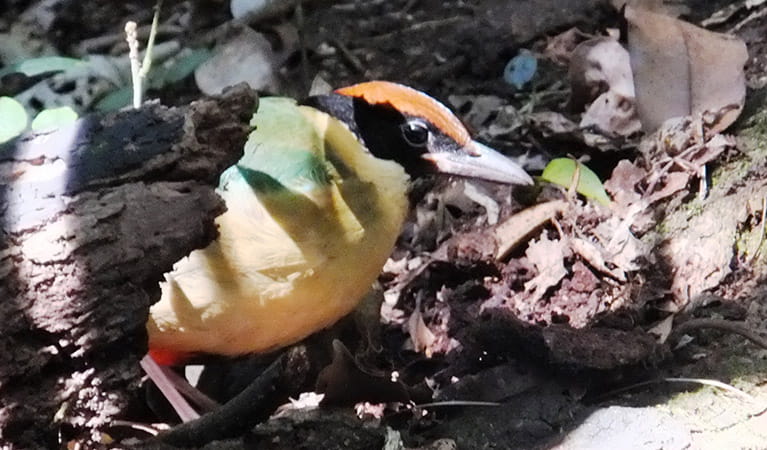
Can you hear the pouched frog? It’s a very quiet ‘eh-eh-eh-eh-eh-eh’. Did you know that the sound of the eastern whipbird is a duet? The first long note comes from the male and then the female joins in with her whip crack response. From the high canopy down to the forest floor live a huge variety of animals and birds to see and hear. Though some, like the carpet python, land mullet, eastern small-eyed snake, lace monitor, black-bellied marsh snake and long-nosed potoroo, are very quiet creatures. Plant species in Wollumbin seem varied to the extremes. There are prettily-named ones such as maidenhair, silkpod, watervine, wait-a-while, tree fern, wilkiea and red apple. These live alongside Wollumbin zieria, with its warty and felted branchlets, the prickly shield fern, stinging nettle, flooded gum, giant spear lily, dogwood, turpentine and, most disconcerting, giant stinging tree.
- Lyrebird track Lyrebird track is a short walk in Wollumbin National Park. It leads from Mount Warning Road across Breakfast Creek to a lookout surrounded by rainforest.
Plants and animals protected in this park
Animals
-
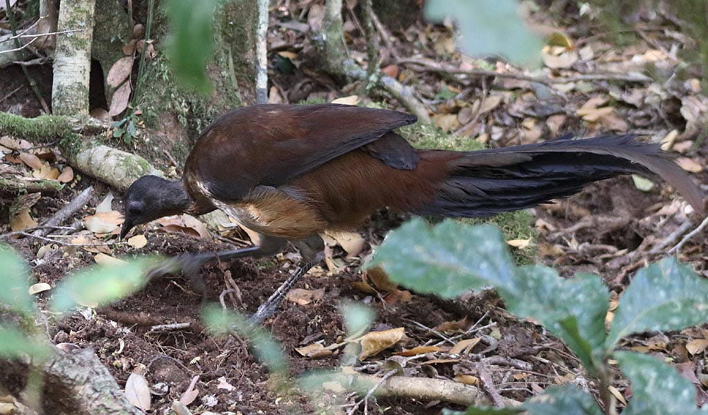
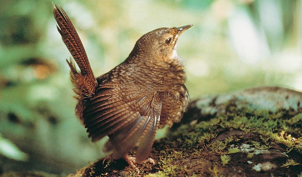
Albert's lyrebird (Menura alberti)
The Albert’s lyrebird is much rarer than the superb lyrebird. Distinguished by its richer brown plumage and less elaborate tail feathers, it’s protected as a threatened species in NSW.
-
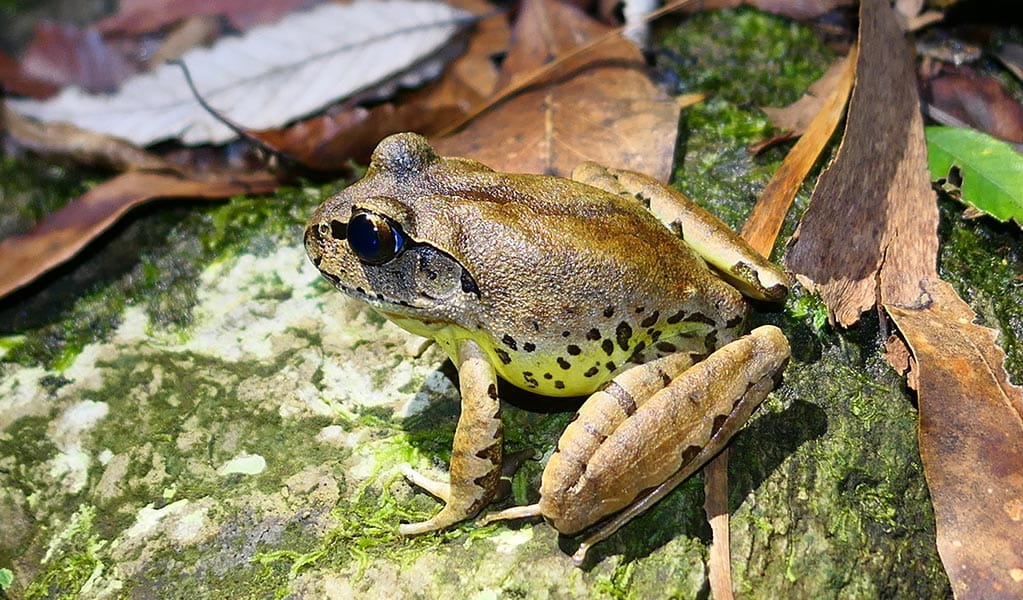
Fleay's barred frog (Mixophyes fleayi)
The Fleay’s barred frog is an endangered species restricted to rainforest stream habitats in north-east NSW and south-east Queensland.
-
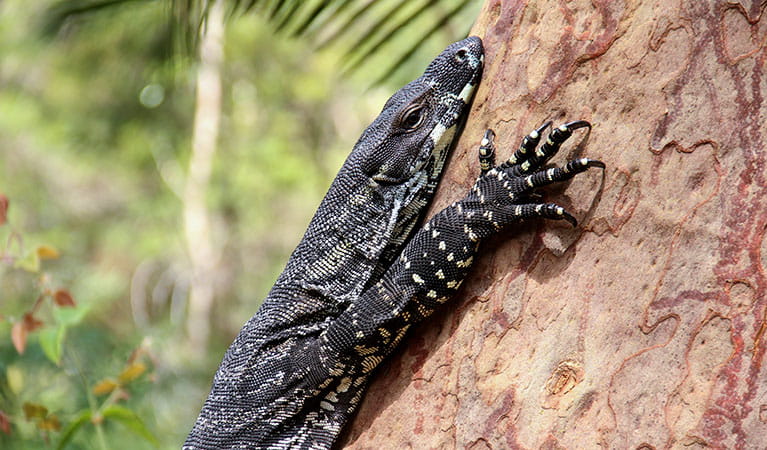
Lace monitor (Varanus varius)
One of Australia’s largest lizards, the carnivorous tree-dwelling lace monitor, or tree goanna, can grow to 2m in length and is found in forests and coastal tablelands across eastern Australia. These Australian animals are typically dark blue in colour with whitish spots or blotches.
-
Rufous scrub-bird (Atrichornis rufescens)
The vulnerable rufous scrub-bird is a small, ground-foraging bird that lives only in isolated rainforest areas of south-eastern Australia.
-
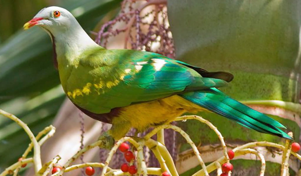
Wompoo fruit-dove (Ptilinopus magnificus)
The wompoo fruit-dove is a marvellously multi-coloured pigeon that makes its home in rainforest along coastal ranges from mid-north NSW to southern Queensland. It’s protected as a vulnerable species in NSW.
-
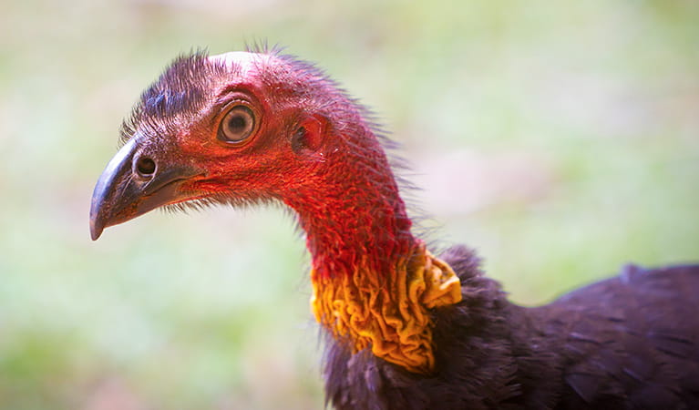
Australian brush turkey (Alectura lathami)
The Australian brush turkey, also known as bush or scrub turkey, can be found in rainforests along eastern NSW. With a striking red head, blue-black plumage and booming call, these distinctive Australian birds are easy to spot while bird watching in several NSW national parks.
Environments in this park
Education resources (1)
What we're doing
Wollumbin National Park has management strategies in place to protect and conserve the values of this park. Visit the OEH website for detailed park and fire management documents. Here is just some of the work we’re doing to conserve these values:
Preserving biodiversity
Wollumbin protects habitat for the threatened koala, little bentwing-bat, southern myotis and powerful owl. It also supports wet sclerophyll forest, rainforest and dry sclerophyll vegetation. All management activities will involve environmental or heritage assessments to ensure biodiversity values within this park are prioritised.
Managing weeds, pest animals and other threats
Pests and weeds have a significant impact to the ecosystems within Wollumbin National Park. NPWS carries out risk assesments for new and emerging weeds as well as wild dog control to protect biodiversity in this park.
Conserving our Aboriginal culture
Wollumbin is a sacred place of deep cultural significance to Aboriginal People, particularly the Bundjalung nation, with cultural connections across Australia.
In 2014, an Aboriginal Place was declared over the upper reach of Wollumbin, including the summit, affording Wollumbin special legal protections, recognising and protecting Aboriginal cultural values, and ensuring a greater role for Aboriginal custodians to make decisions on managing the site.
An Aboriginal Place Management Plan has been prepared to document Wollumbin's significant cultural heritage values and articulate the aspirations of Aboriginal communities about the long-term management of the site.
The plan was prepared in consultation with Aboriginal communities, including the Wollumbin Consultative Group.
The Wollumbin Aboriginal Place Management Plan is available on the Environment and Heritage website.
Managing fire
NSW is one of the most bushfire prone areas in the world as a result of our climate, weather systems, vegetation and the rugged terrain. NPWS is committed to maintaining natural and cultural heritage values and minimising the likelihood and impact of bushfires via a strategic program of fire research, fire planning, hazard reduction, highly trained rapid response firefighting crews and community alerts.