Yerong walking track
The Rock Nature Reserve - Kengal Aboriginal Place
Affected by closures, check current alerts
Overview
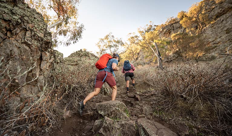
Yerong walking track offers a moderately challenging hike up the slopes of The Rock to a spectacular lookout over bush and surrounding farmland.
- Distance
- 6km return
- Time suggested
- 2hrs 30min - 3hrs 30min
- Grade
- Grade 3
- Trip Intention Form
-
It's a good idea to let someone know where you're going. Fill in a trip intention form to send important details about your trip to your emergency contact.
- Personal Locator Beacon
-
If you're planning to hire a PLB for free at one of these locations, wait and fill out your trip intention form in person.
- Opening times
The Rock Nature Reserve – Kengal Aboriginal Place is always open but may have to close at times due to poor weather or fire danger.
- What to
bring - Hat, sunscreen, drinking water
- Please note
- Remember to take your binoculars if you want to go birdwatching.
- The weather in the area can be extreme and unpredictable, so please ensure you’re well-prepared for your visit.
Leaving directly from the carpark near the information point, this pleasant and accessible walk takes visitors to the top of the dramatic The Rock formation. It begins gently, crossing small gravelled slopes between graceful red gums.
As you climb higher, the path begins to wind around recessed cliffs hiding cool woolly ragwort plants – a threatened species native to the area that blooms with yellow flowers. Wallabies scatter through the undergrowth, lizards bask in the warm sun, and you may see glossy black cockatoos or wedge-tailed eagles circling overhead. Birdwatching only gets better the further you climb.
This hike becomes steep towards the end, so make sure you bring some sturdy shoes and plenty of water. The payoff is notable, though, with a spectacular scenic vista across bush and rolling farmland from the top of The Rock, providing an excellent opportunity for photography. Just a short trip from Wagga Wagga, this is one of the best lookouts in the region. Galore Hills is often visible to the west, and on clear winter days the snow-capped peak of Mount Kosciuszko rises in the distance. The nearby The Rock picnic area offers a great place to stretch your legs afterwards, too.
Map
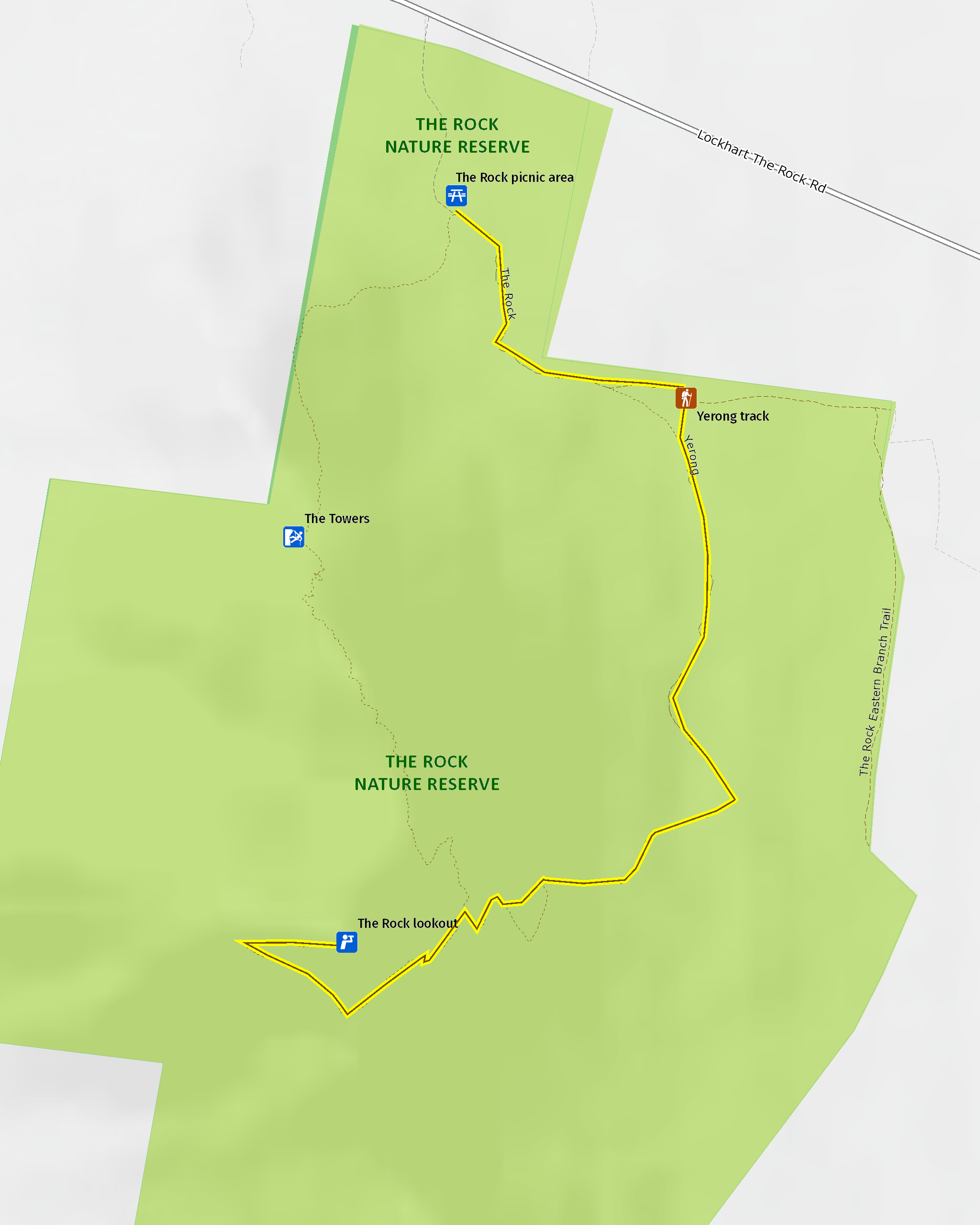
Map legend

Local alerts
For the latest updates on fires, closures and other alerts in this area, see https://www.nationalparks.nsw.gov.au/things-to-do/walking-tracks/yerong-walking-track/local-alerts
General enquiries
- National Parks Contact Centre
- 7am to 7pm daily
- 1300 072 757 (13000 PARKS) for the cost of a local call within Australia excluding mobiles
- parks.info@environment.nsw.gov.au
Park info
- in The Rock Nature Reserve - Kengal Aboriginal Place in the Murray-Riverina region
The Rock Nature Reserve – Kengal Aboriginal Place is always open but may have to close at times due to poor weather or fire danger.
Visitor info
All the practical information you need to know about Yerong walking track.
Track grading
Features of this track
Distance
6km return
Time
2hrs 30min - 3hrs 30min
Quality of markings
Sign posted
Experience required
Some bushwalking experience recommended
Gradient
Short steep hills
Steps
Occasional steps
Quality of path
Formed track, some obstacles
Getting there and parking
Yerong walking track starts at The Rock picnic area in The Rock Nature Reserve – Kengal Aboriginal Place. To get there:
- From Wagga Wagga, follow the Sturt Highway west
- Turn left onto the Olympic Highway
- Continue to The Rock and turn right onto Urana Street
- Heading out of town this becomes Lockhart -The Rock Road
- Continue for approximately 2.5km
- Turn left into The Rock Nature Reserve – Kengal Aboriginal Place and continue for approximately 500m to the picnic area
- Yerong walking track begins near the information shelter.
Parking
Parking is available at The Rock picnic area including bus parking.
Best times to visit
There are lots of great things waiting for you in The Rock Nature Reserve Kengal Aboriginal Place. Here are some of the highlights.
Autumn
Cooler days after the high heat of summer make this the perfect season to take advantage of the picnic area, stretching out beneath the red gums.
Spring
Spring sees the park bloom with wildflowers, including woolly ragwort, a threatened species native to the area.
Winter
The crisp clear air of winter provides views from the top of The Rock that sometimes stretch all the way to Mount Kosciuszko; this is the best season for walking.
Weather, temperature and rainfall
Summer temperature
Average
13.9°C and 28.5°C
Highest recorded
43.7°C
Winter temperature
Average
4°C and 13.5°C
Lowest recorded
-4.2°C
Rainfall
Wettest month
October
Driest month
February
The area’s highest recorded rainfall in one day
87.2mm
Maps and downloads
Prohibited
Camping
No camping is permitted.
Pets
Pets and domestic animals (other than certified assistance animals) are not permitted. Find out which regional parks allow dog walking and see the pets in parks policy for more information.
Smoking
NSW national parks are no smoking areas.
Learn more
Yerong walking track is in The Rock Nature Reserve - Kengal Aboriginal Place. Here are just some of the reasons why this park is special:
Geological significance

The reserve sits on the boundary between two major biophysical regions: the Riverine Plains and the western slopes of the Eastern Highlands. This geographic mix gives the area a terrific diversity of landscapes and animal habitats. The Rock itself, unique in the district, is the result of a pressure uplift of sedimentary materials, and is the highest point of a hogback ridge running north to south (The Rock is at the northern end). The summit stands 364m above the surrounding plains.
- Aboriginal special places guided tours Join Bundyi Cultural Tours in The Rock Nature Reserve - Kengal Aboriginal Place, near Wagga Wagga to explore ancient Wiradjuri culture in a beautiful and timeless landscape.
- The Towers The Towers is a 100m stretch of the north-east face of The Rock, open to rock sports and also popular with photographers and birdwatchers who want to view peregrine falcons.
Living Aboriginal culture: Kengal

The dual name of the nature reserve (since 2005) acknowledges a Wiradjuri cultural presence that stretches back many generations. The Rock is also known as Kengal (meaning ‘sloping hill’), a Dreaming place, lookout, and ceremonial site for the Wiradjuri People and their descendants. It was once used for male initiation rituals. Traditional lore has it that Kengal was created by Baiame, the creator who also taught the Wiradjuri People how to make fire and spears. When settlers arrived in the area, stories go, Baiame left his male and female dingo (Mirrigan) companions, who lay in wait for Baiame’s return, forming The Rock.
- Aboriginal special places guided tours Join Bundyi Cultural Tours in The Rock Nature Reserve - Kengal Aboriginal Place, near Wagga Wagga to explore ancient Wiradjuri culture in a beautiful and timeless landscape.
'The Hanging Rock’

Charles Sturt first saw The Rock in 1829, though the area wasn’t settled further by Europeans until 1874. They called the remarkable geological feature ‘The Hanging Rock’ because of an overhang on its eastern face. This collapsed in 1874, however, leading to the adoption of its current name – simply, ‘The Rock’. For much of its modern life, the feature has sat on Crown land, and from 1891 its lower slopes were quarried for road base material to provide ballast on a Sydney-Melbourne rail line.