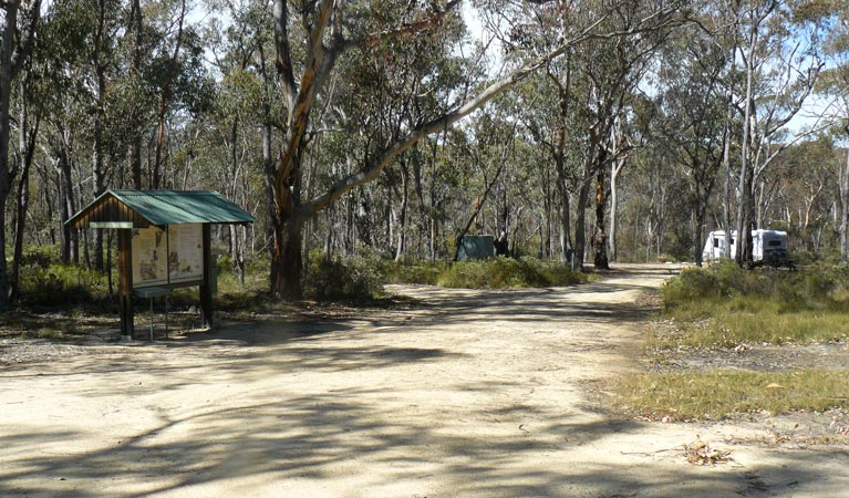
Blatherarm campground and picnic area
Open, check current alerts
Overview
Blatheram campground and picnic area at Torrington State Conservation Area is great for walking or hiking, indulging in birdwatching, or even fossicking for rocks.
| Number of campsites | 10 |
|---|---|
| Camping type | Tent, Camper trailer site, Caravan site, Camping beside my vehicle |
| Facilities | Toilets, unpowered sites, marked sites, barbecue facilities, picnic tables, carpark |
| What to bring | Firewood |
| Bookings | Book up to 12 people or 2 sites online. |
| Group bookings | School groups and Park Eco Pass holders can make a group booking enquiry. |
| Please note |
|
Pack a picnic, pull up your caravan or pitch a tent and enjoy the peaceful surroundings offered by this remote bush campground and picnic area.
Wander down to the creek and try your luck fossicking for topaz, beryl or quartz. Or just sit back and enjoy the sounds of running waters as you watch out for the local birdlife with your camera ready. Is that a Turquoise Parrot nesting in trees in the distance?
If you’re feeling energetic and ready to explore, why not go for a short and easy walk to see the stunning wildflower displays along the Ugly Corner Falls walking track.
When you’re done exploring, head back to your campsite, get a fire going for a hot chocolate and barbecue dinner. Then let the night sounds of the bush rock you to sleep before another day of adventure begins.
Map
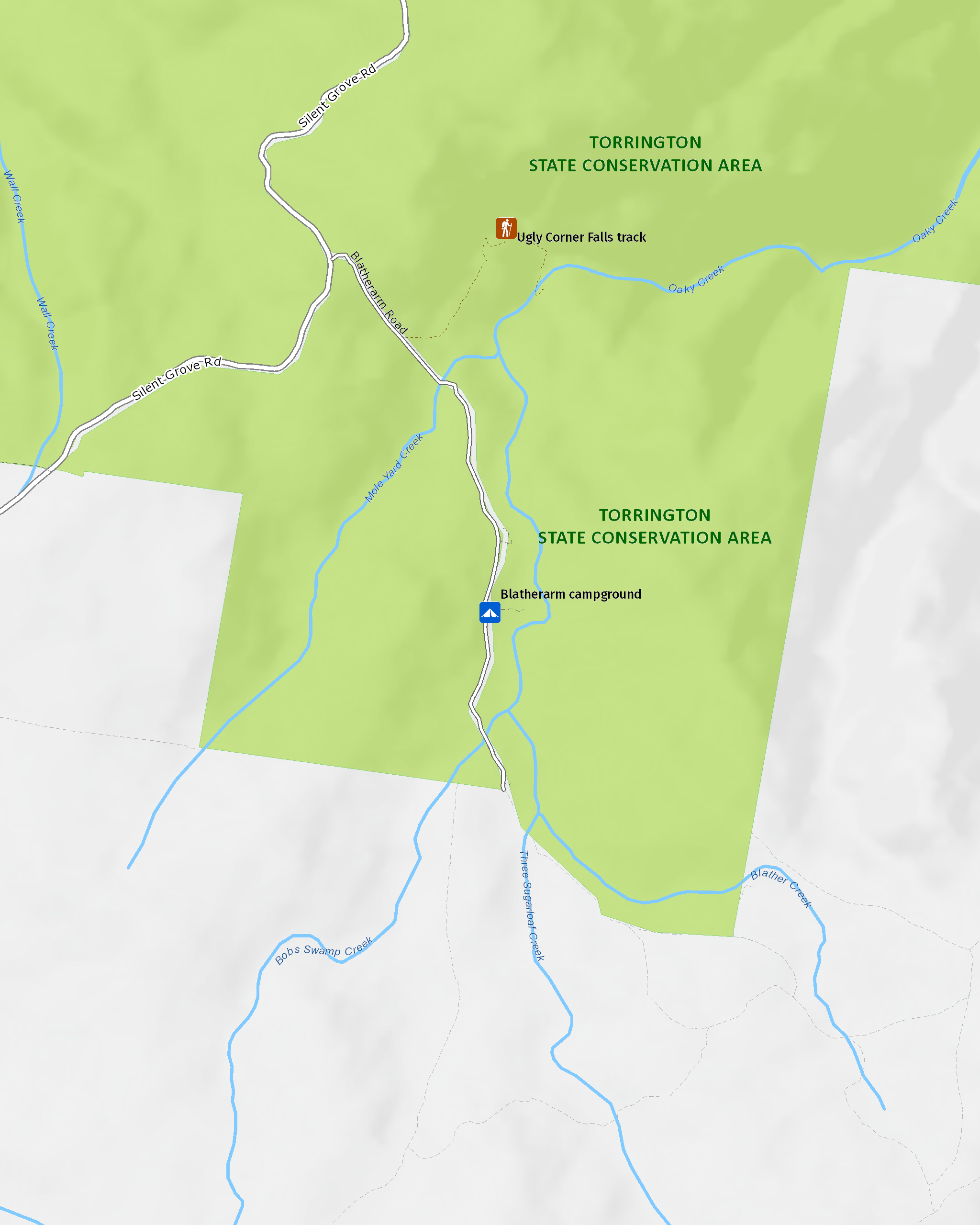
Map legend

Local alerts
For the latest updates on fires, closures and other alerts in this area, see https://www.nationalparks.nsw.gov.au/camping-and-accommodation/campgrounds/blatherarm-campground-and-picnic-area/local-alerts
Bookings
- National Parks Contact Centre
- 7am to 7pm daily
- 1300 072 757 (13000 PARKS) for the cost of a local call within Australia excluding mobiles
- parks.info@environment.nsw.gov.au
Operated by
- Glen Innes office
- Monday to Friday, 8.30am to 4.30pm.
- 02 6739 0700
- npws.ntab@environment.nsw.gov.au
- 68 Church Street, Glen Innes NSW 2370
Visitor info
All the practical information you need to know about the Blatherarm campground and picnic area.
Getting there and parking
Blatherarm campground is in the north-eastern precinct of Torrington State Conservation Area. To get there:
- After passing through the township of Torrington take a right turn at the old pub into Silent Grove Road
- Follow for approximately 10km to the Blatherarm Road turnoff on your right
- After 1.5km you will see access on your left to the campsite areas 1 and 2. To access campsite area 3 you will need a 4WD to cross the creek.
Road quality
Check the weather before you set out as the road to this campground can become boggy when it rains.
- Unsealed roads
Vehicle access
- 2WD vehicles
Weather restrictions
- 4WD required in wet weather
Parking
Parking is available at Blatherarm campground and picnic area.
Best times to visit
There are lots of great things waiting for you in Torrington State Conservation Area. Here are some of the highlights.
Spring
See the spectacular display of spring wildflowers as the boronias, grevilleas, prostantheras and many other native wildflowers turn the bush into a vibrant display of colour.
Summer
Wander through the bush, dotted with colourful wildflowers, as you take in the magnificent granite formations on the Mystery Face walking track.
Weather, temperature and rainfall
Summer temperature
Average
13°C and 31°C
Highest recorded
41.2°C
Winter temperature
Average
1°C and 19°C
Lowest recorded
-10.6°C
Rainfall
Wettest month
January
Driest month
June
The area’s highest recorded rainfall in one day
361.2mm
Facilities
- There are no shower facilities at this campground.
- Rubbish bins are not available – please take rubbish with you when leaving.
- Tank water is available at this campground – you’ll need to treat or boil it before drinking.
Toilets
- Non-flush toilets
Types of sites
- Unpowered sites
- Marked sites
Barbecue facilities
- Wood barbecues (bring your own firewood)
Picnic tables
Carpark
Maps and downloads
Accessibility
Disability access level - hard
Wheelchairs can access this area with some difficulty.
Permitted
Generators
Generators are permitted to be used in particular areas within this campground
Prohibited
Gathering firewood
Firewood is not provided and may not be collected from the park so you’ll need to bring your own supply.
Pets
Pets and domestic animals (other than certified assistance animals) are not permitted. Find out which regional parks allow dog walking and see the pets in parks policy for more information.
Pets and domestic animals (other than certified assistance animals) are not permitted. For more information, please see the OEH policy.
Smoking
NSW national parks are no smoking areas.