Yerranderie Regional Park
Open, check current alerts
Overview
Yerranderie Regional Park is popular with history buffs and 4WD adventurers for its mining heritage, forgotten ghost town, bushwalking tracks and old silver mine relics.
Read more about Yerranderie Regional Park
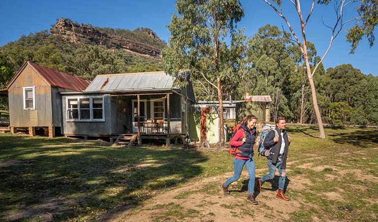
Step back in time at Yerranderie Regional Park, where an intriguing former mining settlement turned ghost town is nestled within a vast and rugged wilderness landscape.
Getting to Yerranderie involves following 76km of dirt road, which only highlights the sense of discovering a land that time forgot.
Cradled under stately escarpments and among wildlife-filled forest lies a unique area with a fascinating mining history. This, combined with its rugged wilderness, makes Yerranderie popular with history buffs, heritage enthusiasts, photographers, and intrepid 4WD enthusiasts alike.
Stroll along the main street of the township and poke around the historic buildings, take short bushwalks into the surrounding bushland, or go 4WD touring along the incredible Oberon Colong historic stock route. At the Yerranderie silver mining fields, you can peer down into the mine from the bridge that lies across the top of one of the large mineshafts.
Book and stay at one of 5 rustic locations just a few steps away from this amazing ghost town, including Government Town campground, Private Town campground, The Bank Room, Post Office Lodge, or Slippery Norris Cottage.
Local alerts
For the latest updates on fires, closures and other alerts in this area, see https://www.nationalparks.nsw.gov.au/visit-a-park/parks/yerranderie-regional-park/local-alerts
Contact
- in the Sydney and surrounds region
Yerranderie Regional Park is always open but may have to close at times due to poor weather or fire danger.
-
-
Oberon office
02 6336 6200
Contact hours: Monday to Friday, 9am to 4.30pm. - 38 Ross Street, Oberon NSW 2787
-
Email: npws.kanangra@environment.nsw.gov.au
-
Oberon office
Visitor info
All the practical information you need to know about Yerranderie Regional Park.
Map
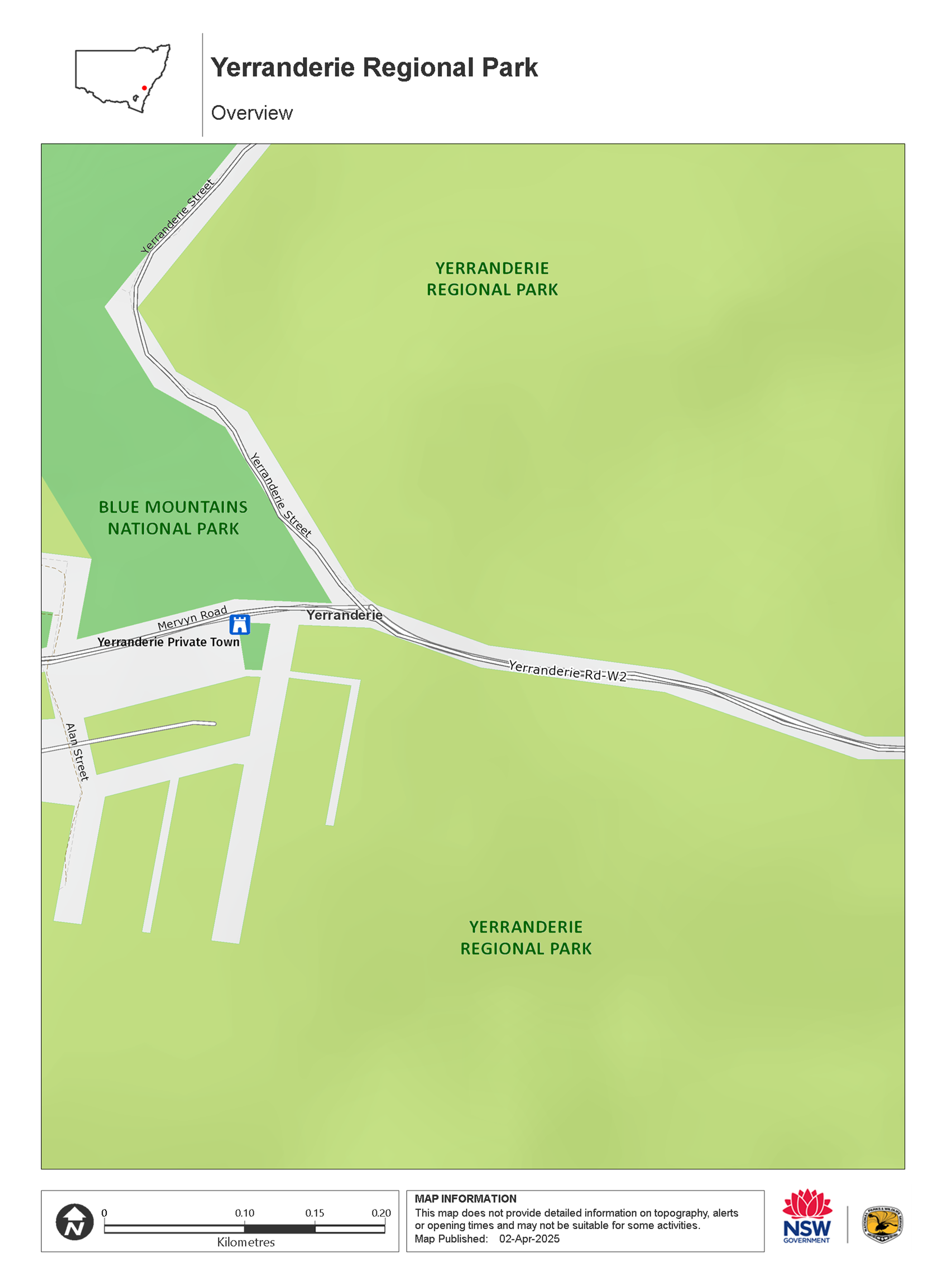
Map
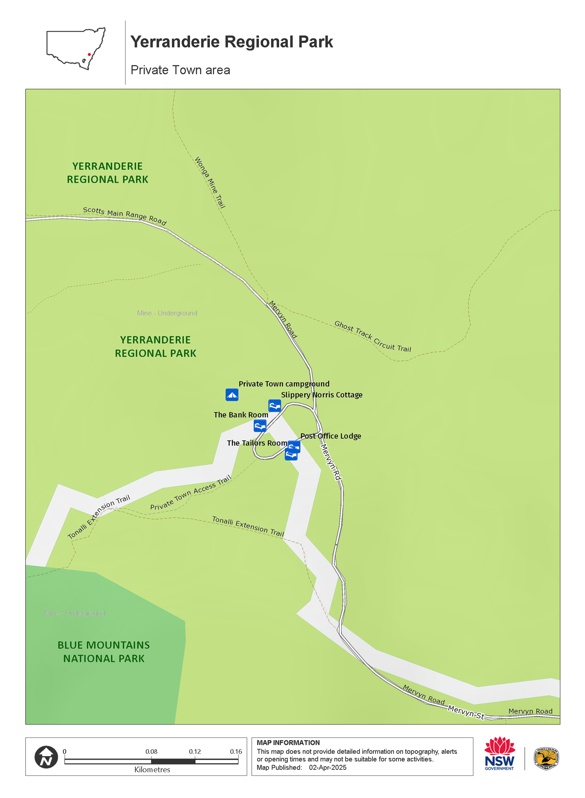
Map legend

Getting there and parking
From Sydney:
- Take the Great Western Highway or Bell's Line of Road then turn south at Hartley onto Jenolan Caves Road. Follow this to the turnoff (right) onto Duckmaloi Road (25km to Oberon).
- Turn south onto Ross Street (in Oberon main street), follow for 400m, turn left to take Edith Road, then right onto Shooters Hill Road.
- Turn left at signage to Mount Werong (follow onto dirt past the Blue Mountains National Park sign and this becomes Oberon Colong stock route, follow this for 60km of dirt (follow yellow Yerranderie Regional Park signs) and turn left.
NB: No immediate access to/from Sydney, only via Goulburn/Oberon areas:
- Please note no access is available from Sydney's west through Burragorang Valley from East (Picton/Oakdale) and there is no access through the valley from the west, in an easterly direction from Yerranderie.
- Schedule 1 protected water catchment access restrictions ensure Sydney’s water quality and prevent any access through this area
- Please be aware that many commercially available online mapping and GPS navigation devices do not have this information listed within, and following these without first programming Goulburn or Oberon as an initial destination will cause navigational issues.
From Jenolan Caves - Kowmung fire trail - Dingo Dell:
- Travellers along this route must have a well-equipped low-range 4WD
- From Jenolan, follow the road south and turn left into Kanangra Road (at Kanangra-Boyd National Park signage).
- Travel towards Boyd River campground, but turn off to the right onto Kowmung River fire trail and descend towards Kowmung River. Those unfamiliar with the country should use topographical maps.
- Cross Kowmung River (always walk the river first to ascertain depth) and traverse two steep ridges.
- Continue on descending into Dingo Dell campground (creek crossing just before this campground), drive past the campground (back uphill) until you reach Banshea Road. Follow this road until the end, where you turn right onto Oberon Colong historic stock route.
Parking
- Private Town campground See on map
- Slippery Norris Cottage See on map
- The Tailors Room See on map
By bike
Check out the Bicycle information for NSW website for more information.
By public transport
Yerranderie Regional Park is not accessible by public transport.
Weather, temperature and rainfall
Summer temperature
Average
17°C and 30°C
Highest recorded
42.8°C
Winter temperature
Average
3°C and 18°C
Lowest recorded
-10°C
Rainfall
Wettest month
March
Driest month
September
The area’s highest recorded rainfall in one day
245.9mm
Facilities
Amenities
Toilets
Showers
Picnic tables
Barbecue facilities
Drinking water
Electric power
Maps and downloads
Prohibited
Pets
Pets and domestic animals (other than certified assistance animals) are not permitted. Find out which regional parks allow dog walking and see the pets in parks policy for more information.
Smoking
NSW national parks are no smoking areas.
Nearby towns
Oberon (108 km)
If the famous Jenolan Caves are on your travel itinerary Oberon in the Blue Mountains is the perfect spot from which to plan your caving adventure. There are a number of ways visitors can tour the caves.
Lithgow (158 km)
Hassans Walls Lookout, near Lithgow, is the highest in the Blue Mountains. Admire Mt Wilson, Mt York, Mt Tarana and Mt Blaxland as well as the pretty Hartley Valley below. To the south are the Kanimbla and Megalong valley and Mt Bindo. While there, go for a walk or ride around the lookout.
Goulburn (162 km)
Named after Henry Goulburn - the British Secretary of State for the Colonies, Goulburn developed into a major centre for wool, and in 1863, it became Australia's first inland city. Today, the town is a rich hub of history, discovery and natural beauty.
Learn more
Yerranderie Regional Park is a special place. Here are just some of the reasons why:
Mining heritage

Yerranderie township has retained much evidence of its history as a mining settlement of the early 20th century through its various remains, sites, mines, architecture and ruins. These, in combination with remnant exotic plantings, road systems and subdivision patterns, bring its early settlement to life for visitors. Yerranderie appears to be the only 20th century mining site to be preserved quasi-intact in all of eastern NSW and is an exceptionally well-preserved archaeological site. The township has been lovingly preserved to reflect its history, but the land itself has not seen much subsequent development due to its isolation. An unusually rich assemblage of mining equipment can still be viewed in the mines, and the township has a varied selection of sites, remains, ruins and buildings.
- 4WD Oberon Colong historic stock route Intrepid 4WD tourers will love the 4WD Oberon Colong historic route. Travel through the wild south of Blue Mountains National Park to a historic mining ghost town in Yerranderie Regional Park.
Dramatic natural environment

Yerranderie lies at the centre of a broad visual catchment surrounded by sandstone escarpments and indigenous bushland. The combination of this spectacular natural setting, strong sense of isolation, and the remnants of mining and settlement activity of the past all contribute to give the township a powerful identity and sense of place.
What we're doing
Yerranderie Regional Park has management strategies in place to protect and conserve the values of this park. View the detailed park and fire management documents.