Chaelundi National Park
Open, check current alerts
Overview
North-west of Dorrigo, Chaelundi National Park has the largest old-growth forest in northern NSW, with fun places to go biking, swimming, picnicking and camping.
Read more about Chaelundi National Park
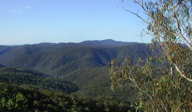
You’d be forgiven for thinking the ‘great outdoors’ actually meant the rugged landscape of Chaelundi National Park.
Bike and walking trails zigzag across spectacular views to the river. Crisp, fresh scents soak the air as you approach sparkling waterfalls and creeks. In the afternoon, a spacious camping area provides the perfect spot for a sausage sizzle by the pretty riverbank.
You’re never really alone either - the forest echoes with wildlife curious enough to join your exploration of deep gullies and old forests that scratch their way through the terrain; frogs, rock wallabies, owls and koalas all add to this diverse forest experience.
The park includes important uses by past communities; scattered artefacts map the ridgelines as traditional travelling routes of local Aboriginal people. Evidence also remains of the bygones of gold and timber industries.
For those keen and prepared, Chaelundi National Park offers unforgettable experiences.
Local alerts
For the latest updates on fires, closures and other alerts in this area, see https://www.nationalparks.nsw.gov.au/visit-a-park/parks/chaelundi-national-park/local-alerts
Contact
- in the North Coast region
Non-wilderness parts of Chaelundi National Park are always open but may have to close at times due to poor weather or fire danger.
-
-
Coffs Harbour office
02 6652 0900
Contact hours: Monday to Friday, 8.30am to 4.30pm. - 4/32 Edgar St, Coffs Harbour NSW 2450
-
Email: npws.coffscoast@environment.nsw.gov.au
-
Coffs Harbour office
Visitor info
All the practical information you need to know about Chaelundi National Park.
Map
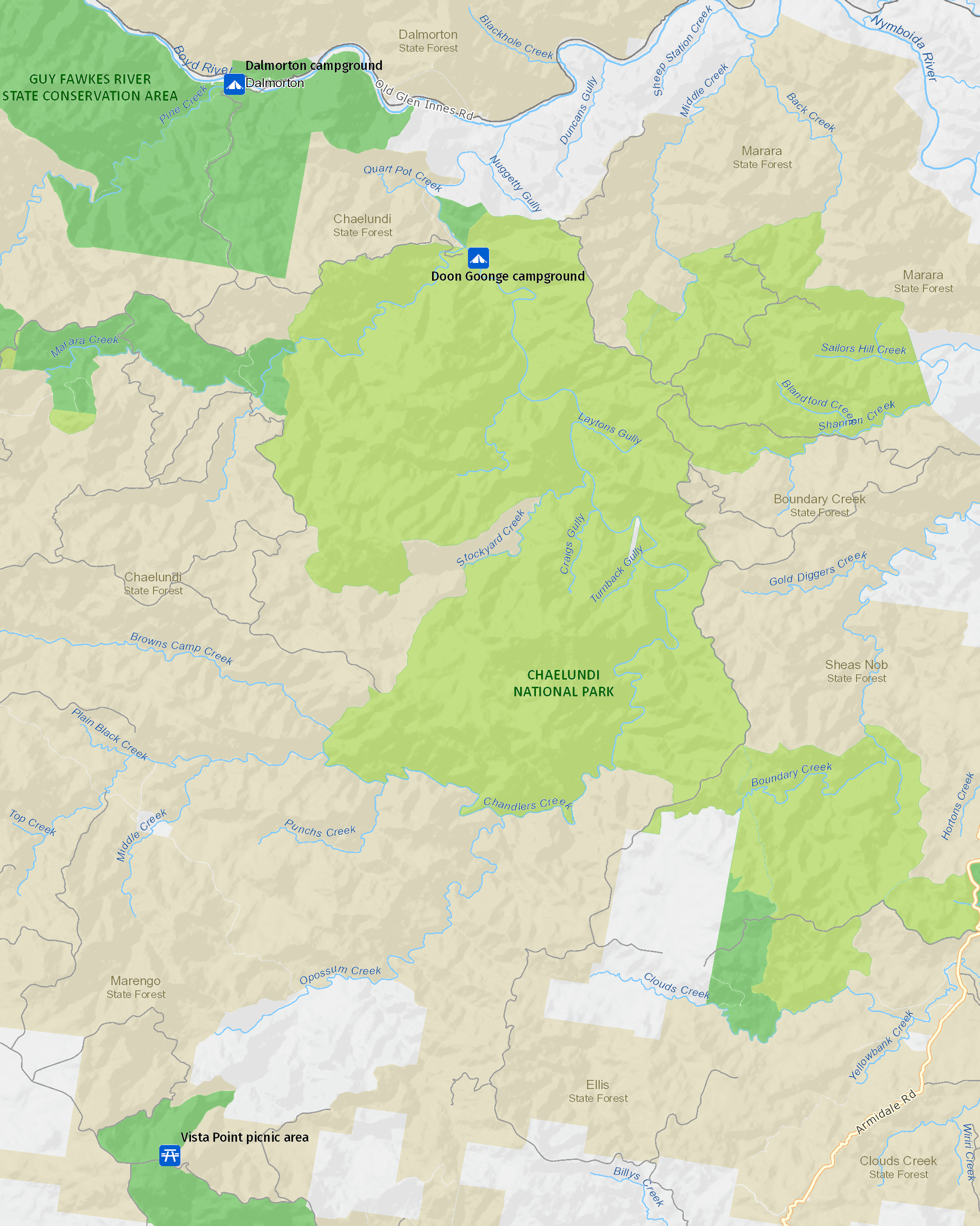
Map legend

Getting there and parking
Get driving directions
From Nymboida:
- Drive 5km south along Armidale-Grafton Road, then turn right onto Boundary Creek Road. Follow Boundary Creek Road for around 23km, until you reach Link Road.
From Dundurrabin:
- Take the Sheep Station Creek turn-off on Armidale-Grafton Road at Dundurrabin. Continue along Chaelundi Road, stopping at Vista Point for the views into Chaelundi wilderness and, further along, Guy Fawkes lookout for the views into Guy Fawkes River gorge. Continue along Chaelundi Road and turn right into Quartz Road.
- Drive 16.5km north along Armidale-Grafton Road to Clouds Creek. Continue for 3.5km north along Armidale-Grafton Road, then turn left onto Tallowwood Road, where you enter the park.
From South Grafton:
- Travel south along Armidale-Grafton Road to Nymboida, then follow the directions as above.
- Travel west along the Gwydir Highway, then turn left onto Old Grafton-Glen Innes Road for around 60km to the abandoned gold-mining village of Dalmorton. Turn left onto Chaelundi Road and travel south for around 6km, then turn left onto Quartz Road.
Parking
- Doon Goonge campground See on map
By bike
Check out the Bicycle information for NSW website for more information.
By public transport
Chaelundi National Park is not accessible by public transport.
Best times to visit
There are lots of great things waiting for you in Chaelundi National Park. Here are some of the highlights.
Autumn
Photography of forest and cycads fruiting.
Spring
Wilderness bushwalking along Chandler Creek gorge.
Summer
Remote camping, fishing and swimming in Chandler Creek.
Weather, temperature and rainfall
Summer temperature
Average
28°C and 30°C
Highest recorded
43.8°C
Winter temperature
Average
21°C and 24°C
Lowest recorded
-2.2°C
Rainfall
Wettest month
February
Driest month
September
The area’s highest recorded rainfall in one day
274.3mm
Facilities
Maps and downloads
Prohibited
Pets
Pets and domestic animals (other than certified assistance animals) are not permitted. Find out which regional parks allow dog walking and see the pets in parks policy for more information.
Smoking
NSW national parks are no smoking areas.
Nearby towns
South Grafton (59 km)
The Clarence is one of Australia's largest waterways and offers a host of water adventures to suit all styles. Choose from high-adrenalin whitewater rafting, to canoeing and kayaking, or a river cruise.
Grafton (61 km)
Grafton is a gracious, historic city in the Clarence Valley farming district. It's situated on the broad Clarence River and surrounded by river flats.
Dorrigo (85 km)
Dorrigo is a serene country town and the gateway to Dorrigo National Park. Its close to the edge of the escarpment above the Bellingen Valley.
Learn more
Chaelundi National Park is a special place. Here are just some of the reasons why:
Waiting just for you

Fire trails twist and turn through scenery for mountain bikers to zip through, offering spectacular views to the river below. Crisp, fresh scents moisten the air on approaching a waterfall or creek. You can relax here with a cooling dip before heading to sizzle your sausages by the riverbank campsite. Car touring on forest roads outside the wilderness zone are ready for exploration by 4WD.
Mountain of gold

By 1872, there were over 500 people living in Dalmorton, working numerous gold reefs in the area. Evidence of this gold-mining history includes vertical and horizontal mine shafts of several abandoned gold mines. Mining finally ceased in the 1930s. There is also a long history of timber harvesting within the Chandlers Creek basin extending back to the late 1800s, with cedar-getting followed by logging of hoop pine up until 1930. Small shelters can still be found dotted along the landscape as remnants of the industry.
Living and thriving

The diverse forest environments and substantial old-growth sections make the Chaelundi National Park areas ecologically unique. The park harbours around 18 threatened animal species, including the rock wallaby, stuttering frog and regent honeyeater.
Ancient pathways

Chaelundi National Park lies within the territory of the Gumbaynggirr Aboriginal people. Many of the ridgelines within the park are considered to be of high cultural significance to local Aboriginal people as traditional travelling routes. Survey work of the Aboriginal cultural sites within the park has recorded scarred trees, a stone tool quarry and numerous open campsites and artefact scatters.
What we're doing
Chaelundi National Park has management strategies in place to protect and conserve the values of this park. View the detailed park and fire management documents.