Bargo State Conservation Area
Open, check current alerts
Overview
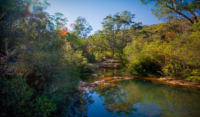
Bargo State Conservation Area is a great place in NSW Southern Highlands for birdwatching, hiking, and swimming at Little River or Moore Creek.
Read more about Bargo State Conservation Area
Just off Hume Highway, there’s an oasis in Bargo State Conservation Area. It’s the perfect place for you to go walking, hiking, or birdwatching. And, when the temperature gets high, you can even cool off from all that activity with a swim in the refreshing natural pools at either Little River or Moore Creek.
Bargo is the traditional land of Dharawal People, and a number of significant Aboriginal sites still exist there today. When Europeans sought inland grazing areas west of Sydney from around 1800, the land was overlooked for being too barren. Apart from a handful of inns and bushranger hideouts, Bargo Brush remained unsettled for many decades and still remains relatively untouched.
Bargo even includes some pockets of warm-temperate rainforest to venture through that are filled with eucalypts and acacias as well as seasonal wildflowers like banskia and geebung, providing great opportunities for some scenic walking or hiking and birdwatching.
Local alerts
For the latest updates on fires, closures and other alerts in this area, see https://www.nationalparks.nsw.gov.au/visit-a-park/parks/bargo-state-conservation-area/local-alerts
Contact
- in the Sydney and surrounds and Country NSW regions
Bargo State Conservation Area is always open but may be closed at times due to poor weather or fire danger.
-
-
Hawkesbury-Nattai office
02 4720 6200
Contact hours: 9am to 4pm Monday to Friday. Glenbrook entry station is only open on weekends, public holidays and school holidays. - 68 Bruce Road, Glenbrook NSW 2773
-
Email: npws.hawkesburynattai@environment.nsw.gov.au
-
Hawkesbury-Nattai office
Visitor info
All the practical information you need to know about Bargo State Conservation Area.
Map
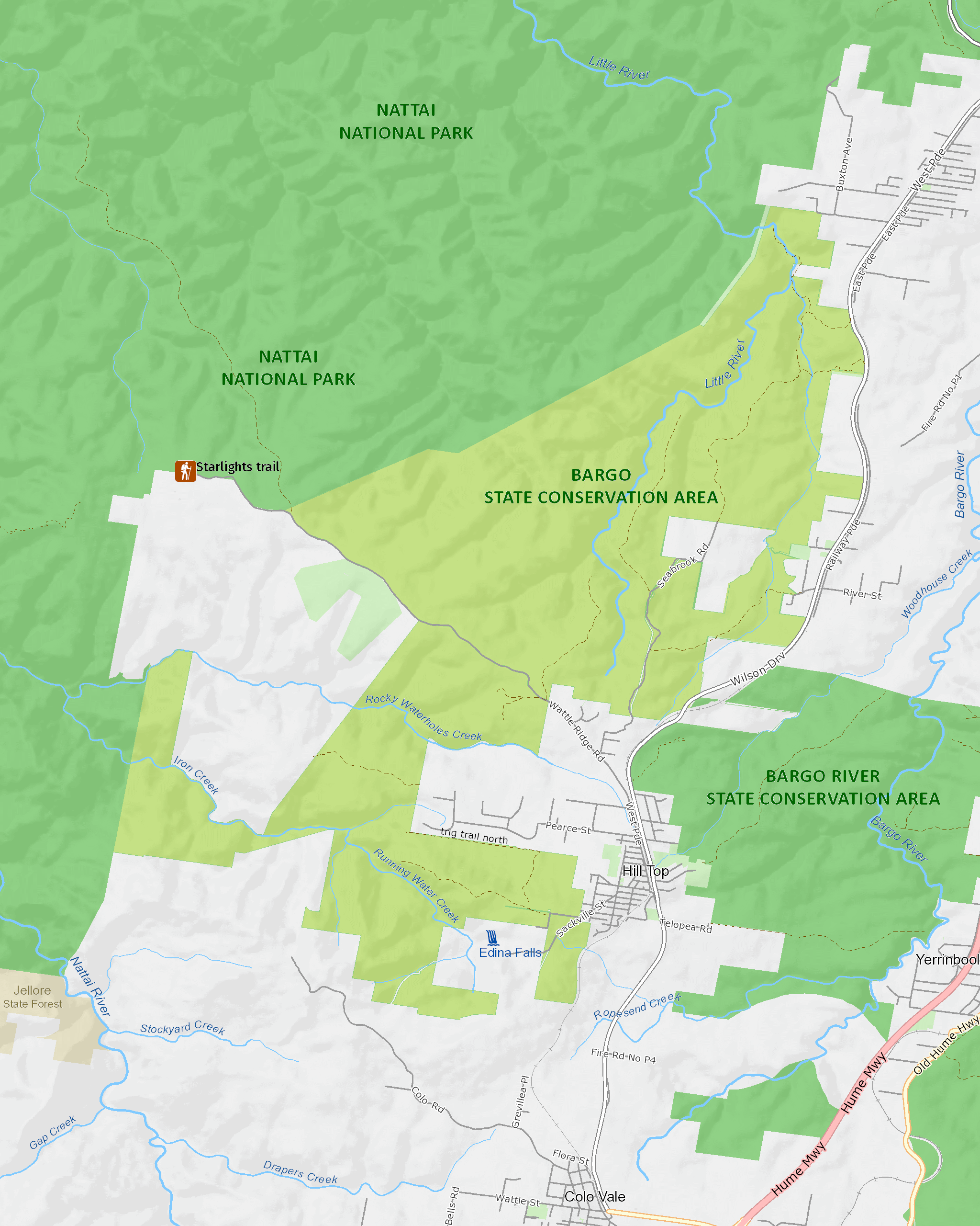
Map legend

Getting there and parking
From Buxton:
- Head southwest on West Parade, which becomes Wilson Drive.
- Travel approximately 2.4 from the centre of Buxton, to the track head of Little River trail.
- To get to the natural swimming pools, walk down 'the steps' trail at the end of Boundary Road in a westerly direction for 500m.
By bike
Cycling is permitted on public roads and designated management trails in Bargo State Conservation Area. Learn about responsible riding and read the cycling policy for more information.
By public transport
Bargo State Conservation Area is accessible by train to Bargo on the Southern Highlands line, then by bus or on foot.
For information about public transport options, visit the NSW transport info website.
Best times to visit
There are lots of great things waiting for you in Bargo State Conservation Area. Here are some of the highlights.
Autumn
Take advantage of the milder weather and enjoy some scenic hiking.
Spring
This season is ideal for bushwalking, swimming and birdwatching.
Summer
You can skip the hike on very hot days and go swimming in the pools along the creeks and river instead.
Weather, temperature and rainfall
Summer temperature
Average
12.2°C and 24.7°C
Highest recorded
29.3°C
Winter temperature
Average
2.6°C and 12°C
Lowest recorded
1.7°C
Rainfall
Wettest month
March
Driest month
September
The area’s highest recorded rainfall in one day
297.4mm
Maps and downloads
Prohibited
Pets
Pets and domestic animals (other than certified assistance animals) are not permitted. Find out which regional parks allow dog walking and see the pets in parks policy for more information.
Smoking
NSW national parks are no smoking areas.
Nearby towns
Mittagong (22 km)
Mittagong has a fine collection of sandstone buildings dating from the early years of European settlement in the mid-19th century. Stroll along Main and Victoria streets to see fine country homes, delightful gardens and specialty shops.
Picton (30 km)
Discover Picton's fine heritage architecture on a self-guided walking tour or visit historic Tahmoor House (limited open days). Enjoy a traditionally-brewed beer at George 4th Inn, opened in 1839 for travellers along the Great South Road.
Campbelltown (66 km)
For nature lovers, the Macarthur region has plenty of natural attractions. Explore nature reserves and wildlife trails or see spectacular native flora and fauna at the Australian Botanic Garden Mount Annan, the largest botanic garden in Australia.
Learn more
Bargo State Conservation Area is a special place. Here are just some of the reasons why:
Wildlife-watch

Enjoy the company of native Australian animals in this reserve, such as eastern grey kangaroos, koalas and platypus. There are also vulnerable tiger quolls and long-nosed potoroos cohabiting with 19 reptile species and nine frog species. The majority of the Bargo local wildlife can be easily spotted early morning or late afternoon. Bargo is also ideal for birdwatching, as there are over 160 species of birds which have been found to nest or feed in the area, including glossy black cockatoos.
Green communities

Bargo is dominated by dry sclerophyll forest that is typical to NSW, but the reserve also houses pockets of warm-temperate rainforest. Eleven rare plant species grow within these rainforest areas, including hairy and Mittagong geebung, narrow-leaved mallee ash eucalyptus and native cranberry. Given the more barren nature of the soil in this area, it stands to reason that warm-temperate rainforest replaces subtropical rainforest on poorer soils at higher altitudes in NSW.
Bargo Brush

In about 1798, Europeans discovered the Bargo area. Attempts were made to settle the land and run cattle. However, nobody who was granted land outside the colony of Sydney chose to take up the grant in Bargo. The land was considered of poor quality for grazing and people settled further south. Bargo became a feared place and dangerous to travel through. The road built to pass through 'Bargo Brush' became hazardous; the forest, and its thick understorey, was a great place for bushrangers to hide. In 1863, even the established railway line at Picton bypassed Bargo.
Aboriginal connection

The Bargo reserve system falls within the area of Dharawal Land Council. Dharawal People lived mainly on fruits, vegetables, fish and shellfish. The women collected plant foods and were known for their excellent canoeing and fishing skills. Men speared fish and hunted land mammals. The reserve contains numerous reminders of these activities, with Aboriginal sites including axe grinding grooves, wells, engravings and surface artefact sites.
What we're doing
Bargo State Conservation Area has management strategies in place to protect and conserve the values of this park. View the detailed park and fire management documents.