Overview
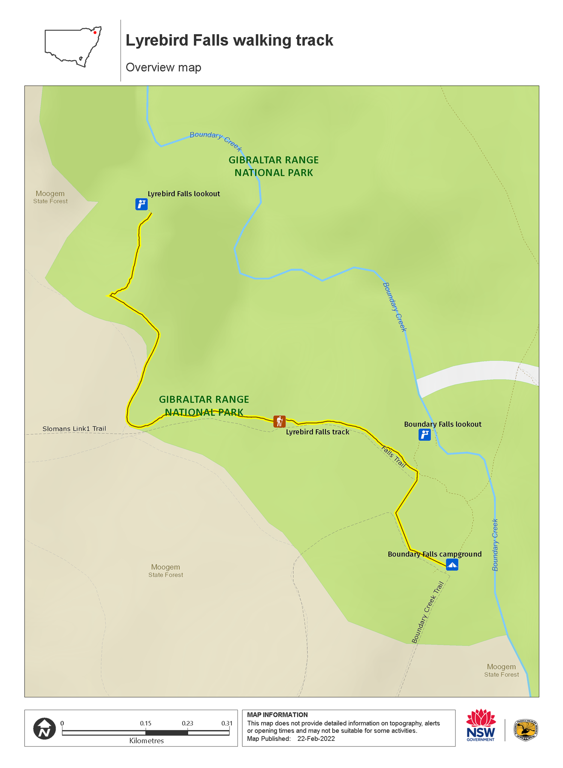
Lyrebird Falls walking track, in Gibraltar Range National Park, is a short walk from Boundary Falls picnic area though eucalypt forest to a scenic waterfall.
- Distance
- 2km return
- Time suggested
- 1hr - 1hr 30min
- Grade
- Grade 4
- Entry fees
- Park entry fees apply
- What to
bring - Drinking water, hat, sunscreen, suitable clothing
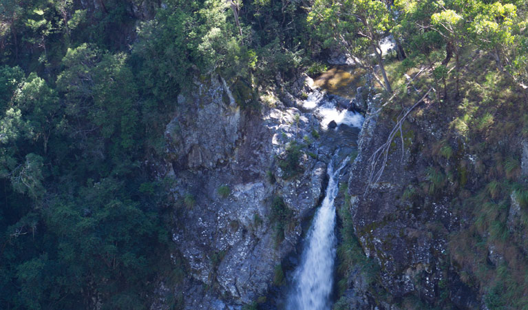
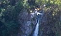
For a delightful in Gibraltar Range National Park that all the family will enjoy, follow Lyrebird Falls walking track through open forest to the edge of the steep-sided valley cut by Boundary Creek. The forest, dominated by tall eucalypts, is also home to grass trees, tree ferns and wattles. The scenic lookout at the end of the track offers views onto gorgeous little waterfalls and over Boundary Creek.
As the name suggests, lyrebirds inhabit the forest areas that this track passes through, so keep an eye out and the binoculars handy. Wedge-tailed eagles can also often be seen soaring above on the thermals.
The trailhead for Lyrebird Falls is at Boundary Falls picnic area, which is just off the highway. So, if you're passing on a road trip through northern NSW, take a break from the road, make a cuppa and stretch your legs along this track.
Also see
-
Lyrebird Falls lookout
Lyrebird Falls lookout is in Gibraltar Range National Park along Lyrebird Falls walking track. Visit this scenic spot to see beautiful little waterfalls and enjoy views over Boundary Creek.
-
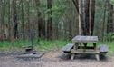
Boundary Falls campground and picnic area
This campsite just off the main road between Glen Innes and Grafton offers great walks, picnic spots, barbecues, and a stunning natural waterfall right nearby.
Map
Map legend

Local alerts
For the latest updates on fires, closures and other alerts in this area, see https://www.nationalparks.nsw.gov.au/things-to-do/walking-tracks/lyrebird-falls-walking-track/local-alerts
General enquiries
- National Parks Contact Centre
- 7am to 7pm daily
- 1300 072 757 (13000 PARKS) for the cost of a local call within Australia excluding mobiles
- parks.info@environment.nsw.gov.au
Park info
- in Gibraltar Range National Park in the North Coast and Country NSW regions
Gibraltar Range National Park is always open but may have to close at times due to poor weather, road damage, or high fire danger.
-
Park entry fees:
$8 per vehicle per day. The park uses a self-registration fee collection system. Please bring the correct change and display your receipt.
Buy annual pass.
Visitor info
All the practical information you need to know about Lyrebird Falls walking track.
Track grading
Features of this track
Distance
2km return
Time
1hr - 1hr 30min
Quality of markings
Limited signage
Experience required
No experience required
Gradient
Flat
Steps
Occasional steps
Quality of path
Formed track
Getting there and parking
Lyrebird Falls walking track is in the Boundary Falls precinct of Gibraltar Range National Park. To get there, travel 63km east from Glen Innes or 97km west from Grafton, along Gwydir Highway.
Parking
Parking is available at Boundary Falls picnic area, a short walk from the start of Lyrebird Falls walking track.
Best times to visit
There are lots of great things waiting for you in Gibraltar Range National Park. Here are some of the highlights.
Spring
The most popular time of the year to visit, spring sees the park erupt into a vibrant display of wildflowers, including the Gibraltar waratah.
Summer
Take in an early morning bushwalk before the day heats up, then cool down in one of the many waterways, like the Little Dandahra Creek.
Winter
It can be below freezing at night, but the daytime temperatures make this the best time of the year to take in some of the longer treks like the Gibraltar-Washpool World Heritage walk.
Weather, temperature and rainfall
Summer temperature
Average
13°C and 24.1°C
Highest recorded
35°C
Winter temperature
Average
1°C and 13.2°C
Lowest recorded
-8.9°C
Rainfall
Wettest month
January
Driest month
August
The area’s highest recorded rainfall in one day
258.4mm
Facilities
Nearest toilets are located at Boundary Falls picnic area
Maps and downloads
Permitted
Camp fires and solid fuel burners
You're encouraged to bring gas or fuel stoves, especially in summer during the fire season.
Prohibited
Pets
Pets and domestic animals (other than certified assistance animals) are not permitted. Find out which regional parks allow dog walking and see the pets in parks policy for more information.
Smoking
NSW national parks are no smoking areas.
Learn more
Lyrebird Falls walking track is in Gibraltar Range National Park. Here are just some of the reasons why this park is special:
Lands of plenty

The European heritage of the park may be shorter, but look around and you'll find its traces clearly etched in the natural environment. Living around the range are direct descendants of graziers, lumberers and miners who made their livings here. Bullock teams and horses once struggled through the bush and granite tors, attempting to tame a landscape that today inspires for its wild ruggedness. Evidence of their work can be glimpsed at Mulligans campground and picnic area, where an aborted hydro-electric scheme from the 1900s is memoralised by a remaining hut and several weirs. Hikers on the wide-reaching Gibraltar-Washpool World Heritage walk might also notice relics of pre-WWII tin and gold-mining operations in the Grassy Creek area.
- Dandahra Crags walking track Dandahra Crags walking track, in Gibraltar Range National Park, is a hiking route with scenic views and birdwatching opportunities.
- Gibraltar-Washpool World Heritage walk Keep an eye out for birds and wildflowers on the 45km Gibraltar-Washpool World Heritage walk through eucalypt forests, rainforests, wetlands and granite tors in the rugged Northern Tablelands.
World Heritage Area

Part of the Gondwana Rainforests Reserves of Australia, Gibraltar Range is listed on the World Heritage register for rainforest plants that have existed since Australia was part of the Gondwana super-continent. Gibraltar Range National Park is home to several threatened species of animal: the endangered giant barred frog, which can grow to the size of a small adult's hand; and glossy black cockatoos, under threat from a loss of breeding habitat. Feeding locations are very important to the continuing survival of the cockatoo.
- Dandahra Falls walking track Suitable for fit and experienced bushwalkers only, Dandahra Falls walking track in Gibraltar Range National Park offers impressive waterfall views in stunning World Heritage surrounds.
- Duffer Falls walking track Within easy reach of Glen Innes or Grafton and ideal for a day trip, Duffer Falls walking track offers waterfall views in the beautiful forest setting of Gibraltar Range National Park.
- Gibraltar-Washpool World Heritage walk Keep an eye out for birds and wildflowers on the 45km Gibraltar-Washpool World Heritage walk through eucalypt forests, rainforests, wetlands and granite tors in the rugged Northern Tablelands.
- Junction Spur walking track For experienced bushwalkers only, Junction Spur walking track in Gibraltar Range National Park will suit adventure seekers who want to get off the beaten track and explore the tablelands.
- The Needles walking track The Needles walking track offers jaw-dropping views of granite rock formations in Gibraltar Range National Park, near Glen Innes. Part of the Gibraltar-Washpool World Heritage walk, it’s a great shorter walk option.
Years in the making

Long stewarded through history by Aboriginal people in the area, the Gibraltar Range continues to hold significance for contemporary descendants. The Range is rich in cultural sites and sacred places, with Aboriginal groups having moved regularly between the tablelands and coastal plains, conducting ceremonies and gathering food along the way.
- Dandahra Crags walking track Dandahra Crags walking track, in Gibraltar Range National Park, is a hiking route with scenic views and birdwatching opportunities.