Overview
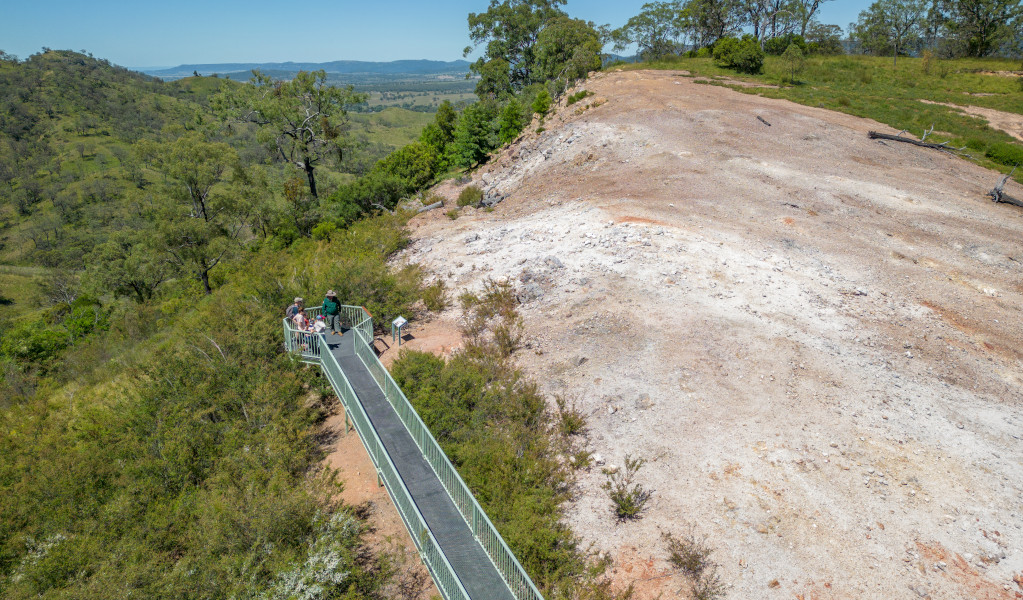
Burning Mountain walk is the best way to discover this unusual nature reserve, with information panels along an accessible 4km return track that has some steep sections.
- Distance
- 4km return
- Time suggested
- 1 - 2hrs
- Grade
- Grade 3
- What to
bring - Drinking water, hat, sunscreen
- Please note
- Remember to take your binoculars if you want to birdwatch
You would expect a fire sizzling below ground for 5,500 years to have some fairly dramatic effects on the vegetation, and the remarkable phenomenon of Burning Mountain is reflected in the plants and animals adapted to life around it. As you set out from the carpark on a moderate walk to the head of the coal seam, expect to pass through eucalypt groves and other types of Upper Hunter woodland. Plenty of dead trees and hollow logs provide homes for lots of wildlife.
As the fire moves one metre every year, the landscape changes: red gums grow along subsidence cracks, and later you’ll come across narrow-leaved stringy bark, tea trees, and stunted grey gums. There are loads of birds in the area, too, so bring the binoculars if birdwatching is an interest.
Anybody interested in the story of what’s going on below ground won’t be disappointed either: information panels along the track unpack the story of Burning Mountain, including its science and fascinating Aboriginal heritage. A viewing platform is located at the climax of Burning Mountain walk, providing a safe vantage point to view the exhaust vents and rocks transformed by extreme temperatures.
Map
Map legend

Local alerts
For the latest updates on fires, closures and other alerts in this area, see https://www.nationalparks.nsw.gov.au/things-to-do/walking-tracks/burning-mountain-walk/local-alerts
General enquiries
- National Parks Contact Centre
- 7am to 7pm daily
- 1300 072 757 (13000 PARKS) for the cost of a local call within Australia excluding mobiles
- parks.info@environment.nsw.gov.au
Park info
- in Burning Mountain Nature Reserve in the Country NSW region
Burning Mountain Nature Reserve is always open but may have to close at times due to poor weather or fire danger.
Visitor info
All the practical information you need to know about Burning Mountain walk.
Track grading
Features of this track
Distance
4km return
Time
1 - 2hrs
Quality of markings
Clearly sign posted
Experience required
No experience required
Gradient
Short steep hills
Steps
Many steps
Quality of path
Formed track, some obstacles
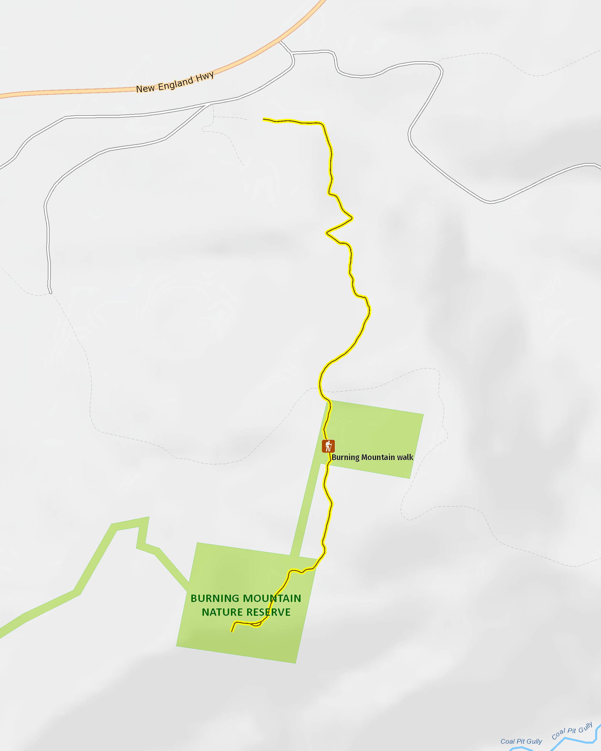
Getting there and parking
Get driving directions
From Scone:
- Follow New England Highway towards Tamworth
- Burning Mountain Nature Reserve is 20km north of Scone, on the right-hand side of the highway.
- The walking track begins from the carpark
Parking
Parking is available, including several designated disabled spots.
Best times to visit
There are lots of great things waiting for you in Burning Mountain Nature Reserve. Here are some of the highlights.
Autumn
Hike Burning Mountain walk and get up close to the remarkable geological event happening right beneath your feet.
Spring
Take the kids and a picnic and keep an eye out for eastern grey kangaroos, wallaroos and echidnas that share the area with copper-tailed skinks and other reptiles.
Weather, temperature and rainfall
Summer temperature
Average
14°C and 30.1°C
Highest recorded
40.6°C
Winter temperature
Average
2.6°C and 15.9°C
Lowest recorded
-6.5°C
Rainfall
Wettest month
January
Driest month
April
The area’s highest recorded rainfall in one day
227.3mm
Maps and downloads
Prohibited
Pets
Pets and domestic animals (other than certified assistance animals) are not permitted. Find out which regional parks allow dog walking and see the pets in parks policy for more information.
Smoking
NSW national parks are no smoking areas.
Learn more
Burning Mountain walk is in Burning Mountain Nature Reserve. Here are just some of the reasons why this park is special:
Aboriginal legend

Traditionally, Burning Mountain was part of a vast territory owned by the Wanaruah people, which stretched from Broke to the Liverpool Range. Wanaruah mythology, passed through generations, tells the story of Burning Mountain like this: one day, the Gumaroi people, north of the Liverpool Range, sent a raiding party south to steal Wanaruah women. The Wiradjuri people to the west warned the Wanaruah, who sent their best warriors out for a great battle. One of the Wanaruah wives decided to wait for her husband to return, settling down near the Liverpool Range. When he didn’t come back, she was devastated. Crying, she asked Biami, the sky god, to take her life. Instead, he turned her into stone, and as she did so, her tears became fire and set the mountain alight for all eternity.
An unusual geological event

The scientific explanation for Burning Mountain is a slowly combusting coal seam. At the moment, the exact location of the fire is a mystery, though we know it’s about 30m below the ground and heading south – meaning Burning Mountain actually moves at about 1m a year. It’s estimated the fire has been burning for as much as 5,500 years, and as it eats through the coal, rocks slip into the gap, causing fissures and slumping at the surface level. Be sure to wear sturdy footwear and stay on the formed track. Not only that, but watch out for fossils, too: 200 million years ago, this entire area was covered by ocean.
The colonial story

The Liverpool Range was always a difficult barrier to the sweeping plains beyond, which colonial settlers coveted for their potential as rich grazing land. Throughout the 1800s, many explorers tried different routes across the area, from ‘Pandora’s Pass’, first crossed by Allan Cunningham in 1823, to the Hanging Rock area, first crossed by Henry Dangar. As you visit the reserve and follow Burning Mountain walk, imagine tackling the landscape without the contemporary luxuries of cars and highways.