Coonabarabran - Warrumbungle - Tooraweenah drive
Warrumbungle National Park
Overview
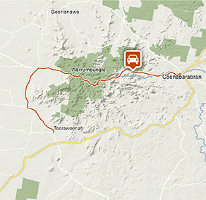
Coonabarabran – Warrumbungle – Tooraweenah drive offers car touring through scenic mountain views with picnicking, walking, and wheelchair accessible facilities in Warrumbungle National Park.
- Where
- Warrumbungle National Park in Country NSW
- Distance
- 70km one-way
- Time suggested
- 4hrs
- Grade
- Medium
- Entry fees
-
Park entry fees apply in Warrumbungle National Park
- Please note
- Wheelchair accessible walking track available at Whitegum lookout
- Picnic facilities are located at Canyon picnic area
- Remember to take your binoculars if you want to birdwatch
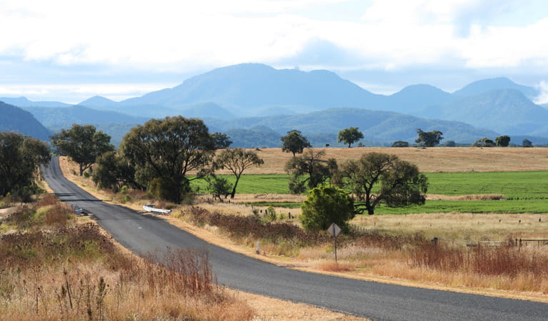
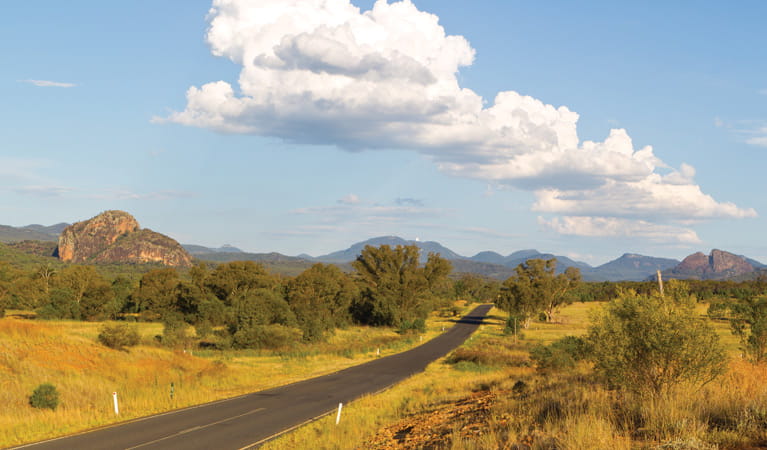
Fancy a leisurely drive through the iconic Warrumbungles, taking in some of the sights that have put this area on the world map? The 70km Coonabarabran – Warrumbungle – Tooraweenah drive combines views, lookouts, and easy walks on a spectacular day trip.
Starting in Coonabarabran, you’ll drive through the picturesque Timor Valley. Highlights worth a visit include the Skywatch Observatory, Timor Rock, and the Anglo-Australian telescope at Siding Spring.
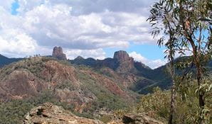
Arriving at the entrance to Warrumbungle National Park, a pit stop at the accessible Whitegum lookout is on the cards. Here, you’ll enjoy a wonderful panorama over the ‘crooked’ mountains across to the impressive Breadknife and Belougery Split Rock.
If you’re feeling like stretching your legs, try the easy Gurianawa walking track or unpack the hamper at nearby Canyon picnic area. Continue through the park towards Tooraweenah, keeping an eye out for majestic Mount Exmouth on your left.
Google Street View Trekker
Using Google Street View Trekker, we've captured imagery across a range of NSW national parks and attractions. Get a bird's eye view of these incredible landscapes before setting off on your own adventure.

Conservation program:
Warrumbungle National Park after-fire program
The 2013 bushfires were the largest and most intense on record for Warrumbungle National Park. Almost 90 per cent of the park was burnt, but conservation programs and research have helped us better understand the impact of fire and how the park has recovered.
General enquiries
- National Parks Contact Centre
- 7am to 7pm daily
- 1300 072 757 (13000 PARKS) for the cost of a local call within Australia excluding mobiles
- parks.info@environment.nsw.gov.au
Operated by
- Warrumbungle NP Visitor Information Centre
- 9am to 4pm daily. Closed Christmas Day.
- 02 6825 4364
- warrumbungle.np@environment.nsw.gov.au
- 4261 John Renshaw Parkway, Warrumbungle NSW 2828
Park info
- in Warrumbungle National Park in the Country NSW region
Warrumbungle National Park is always open but may have to close at times due to poor weather or fire danger.
-
Park entry fees:
$8 per vehicle per day.
Buy annual pass
What's nearby:
Things to do (34)
- Aboriginal culture (5)
- Adventure sports (1)
- Birdwatching and wildlife encounters (10)
- Educational activities (1)
- Historic heritage (1)
- Picnics and barbecues (2)
- Road trips and car/bus tours (2)
- Show cave tours (1)
- Sightseeing (18)
- Swimming (1)
- Visitor centres (1)
- Walking (24)
- Wildflowers (seasonal) (11)