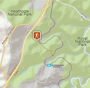
Cawleys Road trail
Garawarra State Conservation Area
Visitor info
All the practical information you need to know about Cawleys Road trail.
Track grading
Features of this track
Distance
2.4km one-way
Time
45min - 1hr 15min
Quality of markings
No directional signage
Experience required
No experience required
Gradient
Gentle hills
Steps
No steps
Quality of path
Formed track
Getting there and parking
Get driving directions
Cawleys Road trail is in the western precinct of Garawarra State Conservation Area. To get there:
- From the F6, take the Helensburgh exit and continue along Parkes Street until you reach the roundabout in the middle of the shopping centre. Continue east along Parkes Street down to Helensburgh Station.
- Drive past the station and to the end of Wilson’s Creek Road to a bridge over the railway line
- Park your car on the roadside, then walk over the bridge into the reserve and the trail on the western side of this bridge is Cawleys Road.
Parking
Parking is available on Wilsons Creek Road or along the Old Princes Highway between Waterfall and Garawarra Hospital.
Best times to visit
There are lots of great things waiting for you in Garawarra State Conservation Area. Here are some of the highlights.
Spring
Blooming wildflowers bring large numbers of birds, making it a perfect time for birdwatching.
Summer
Beautiful weather for bushwalking and cycling, particularly early in the day.
Winter
Clear days, cool weather and low rainfall are perfect for bushwalking.
Weather, temperature and rainfall
Summer temperature
Average
17°C and 27°C
Highest recorded
42°C
Winter temperature
Average
7°C and 18°C
Lowest recorded
-0.6°C
Rainfall
Wettest month
March
Driest month
September
The area’s highest recorded rainfall in one day
254.5mm
Maps and downloads
Prohibited
Camp fires and solid fuel burners
No fires are allowed in this reserve
Pets
Pets and domestic animals (other than certified assistance animals) are not permitted. Find out which regional parks allow dog walking and see the pets in parks policy for more information.
Smoking
NSW national parks are no smoking areas.
Operated by
- Royal National Park Visitor Centre
- 8.30am to 4.30pm daily. Closed Christmas Day.
- 02 9542 0648
- 1300 072 757 for campground and cottage bookings
- npws.royal@environment.nsw.gov.au
- 2 Lady Carrington Drive, Audley, NSW 2232
Park info
- in Garawarra State Conservation Area in the Sydney and surrounds and South Coast regions
Garawarra is open sunrise to sunset but may have to close at times due to poor weather or fire danger.