Gidjuum Gulganyi Walk: Camping self guided
North Coast
Overview
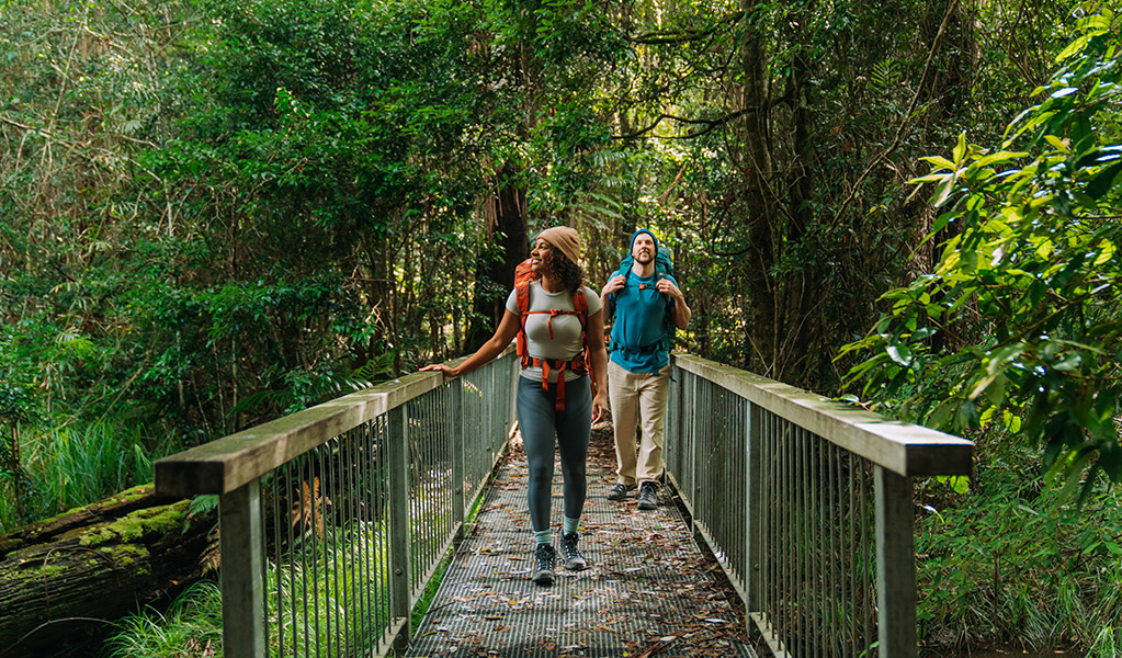
Over 4 days, hike through towering rainforest, clear mountain streams and ancient volcanic landscapes along Gidjuum Gulganyi Walk in the Tweed Byron Hinterland. Camp beneath the forest canopy on hardwood tent platforms.
![]() 4 days 3 nights
4 days 3 nights
![]() 42km Grade 4 - Bushwalking experience recommended
42km Grade 4 - Bushwalking experience recommended
![]() Camp at 3 secluded walk-in campgrounds
Camp at 3 secluded walk-in campgrounds
![]() From $173 for all 3 nights. Pricing is per campsite which fits 1 to 2 people. Excludes transfers. Book an optional return transfer with Vision Walks Eco Tours
From $173 for all 3 nights. Pricing is per campsite which fits 1 to 2 people. Excludes transfers. Book an optional return transfer with Vision Walks Eco Tours
![]() Available all year, 7 days a week
Available all year, 7 days a week
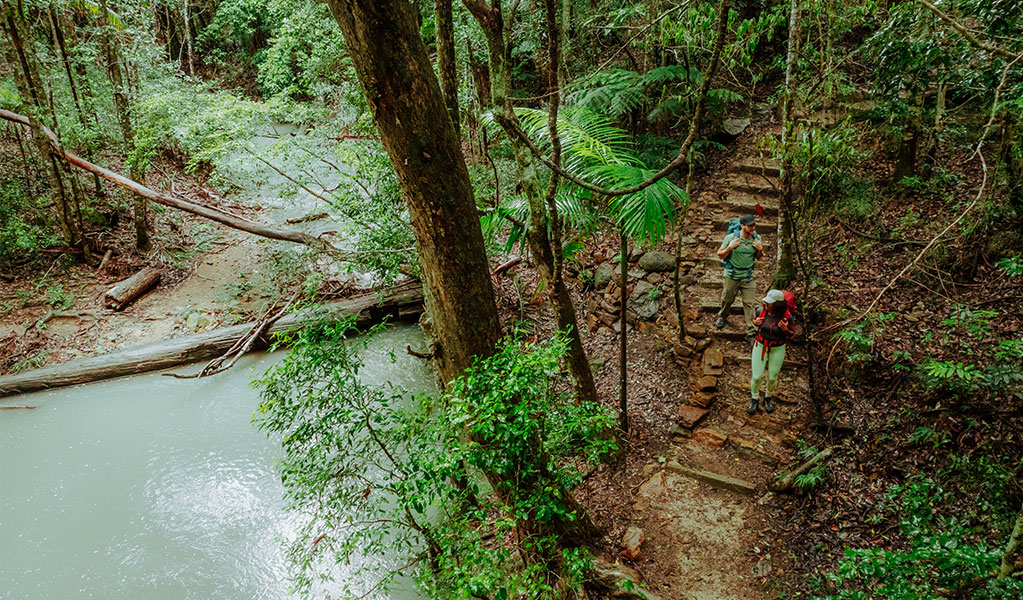
Manns Road track head to Sand Ridge campground
8.5km
Day 1 begins following undulating paths through tall eucalypt and dense rainforests. You’ll then descend under the green canopy of Whiskey Creek gully with its clear waters. End the day with a final climb to Sand Ridge campground, nestled beneath ancient New England blackbutt trees on a serene ridge top. Settle in for an early night – tomorrow’s track will push your endurance.

Sand Ridge campground to Yelgun Kyoomgun campground
16km
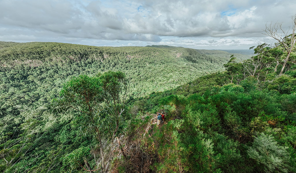
Today’s walk is the longest and most challenging, with steep climbs rewarded by stunning views.
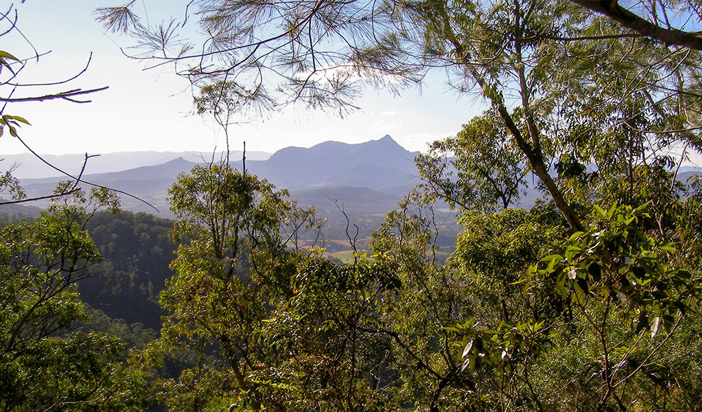
Highlights include Grasstree and Tweed Valley lookouts with magnificent views over the Tweed Caldera. See Wollumbin rising in the distance, the dramatic Jerusalem Cliffs, and ancient rainforests. Cross into Nightcap National Park to Doughboy Mountain View lookout and Postman’s Tree. End at Yelgun Kyoomgun camp with a view to the distant lights of Lismore at night.
Yelgun Kyoomgun campground to Weeun Weeun campground
11.5km
Day 3 features forests, wildlife and dramatic views. Spot orange fungi on mossy carpets and red-legged pademelons darting through the undergrowth. Wanganui Gorge lookout offers sweeping vistas of Coopers Creek and cascading waterfalls. End your day at Weeun Weeun camp, surrounded by towering blackbutt trees and perched across from the rainforest-clad slopes of Goonengerry National Park.

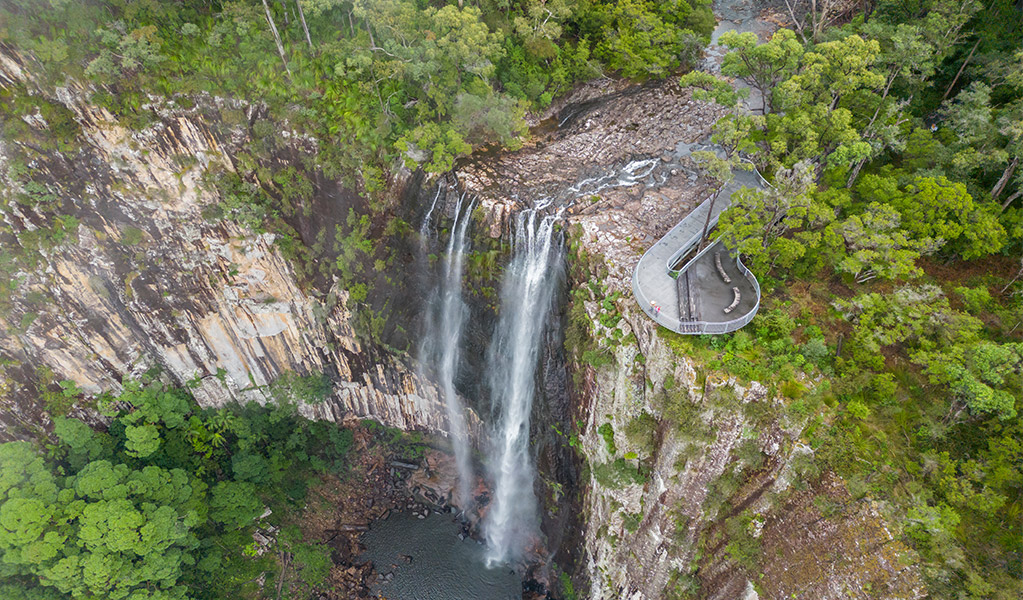
Weeun Weeun campground to Minyon Falls lookout
6km
Wake to the sounds of birdlife and begin the day with clifftop views of Wanganui Gorge and Coopers Creek. The trail winds through rainforest, crossing creeks on narrow boardwalks and stepping stones.
As you near Rummery Park the walk takes you past giant lilies, with the calls of frogs echoing in the damp hollows. Your final destination is the spectacular Minyon Falls lookout.
Where you stay
Night 1 | Sand Ridge campground
Camp under a canopy of ancient New England blackbutt eucalypt on the fringe of the rainforest.

Night 2 | Yelgun Kyoomgun campground
This camp is nestled against a slope with towering blackbutts above and a rich understorey of native mint and sedges. Relax to the calming sounds of the stream when it flows after rain.

Night 3 | Weeun Weeun campground
Camp along the escarpment and enjoy magnificent views of Wanganui Gorge from the nearby lookouts.
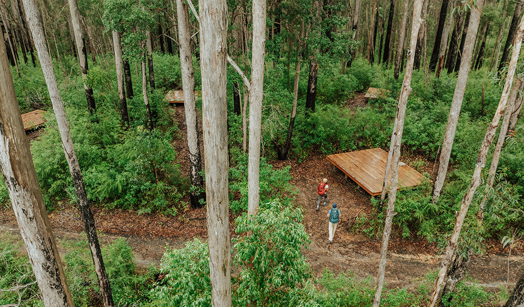
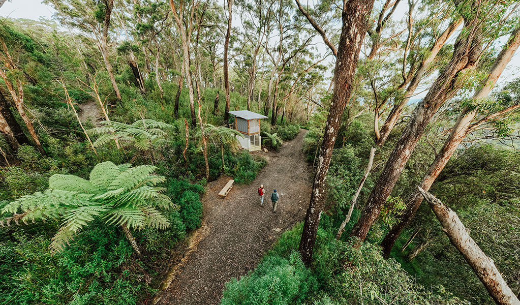
Campground facilities
All 3 campgrounds have:
- Hardwood tent platforms with adjustable chain anchor points to secure the base of your tent.
- Platform size is 4.8 x 3.6m and can fit 1 medium hiker's tent or 2 small hiker's tents.
- Tie down points for guy ropes
- Yarning circles to gather and rest
- Non-flush toilet
- Picnic tables and shelters
- Rainwater tanks. Treat water before drinking.

Detailed itinerary
Is this walk right for you
This is a Grade 4 walk. It's suitable for experienced bushwalkers with strong navigation skills. You need to be fit and prepared for long, sometimes challenging hikes over 4 days, walking 4 to 9 hours daily with all your camping gear. The track features steep sections, many steps, and an elevation gain of about 600m on day 2, reaching 800m. Due to the terrain and length of this walk, you may encounter treefall across the track that requires you to deviate off-track temporarily.
This subtropical climate can be very humid, with creek crossings that may become slippery or deeper during rainfall.
Group bookings
Price and inclusions
From $173 for all 3 nights. Pricing is per campsite – you can fit 1 medium hiker's tent or 2 small hiker's tents on the tent platform.
Includes 3 nights camping on a private hardwood tent platform and shared shelter, seating areas and toilets. Optional transfers available at extra cost. You must bring and carry your tent, food and all your own gear.
Transfers
Take the hassle out of getting there and book a return transfer with Vision Walks Eco Tours. Transfers are available from multiple locations. Prices start from $66 depending on your pickup and drop-off location. Visit the Vision Walks Eco Tours website to book or for more information.
Getting there, parking and road access
If you choose not to book return transfers with Vision Walks Eco Tours, we strongly recommend you get dropped at Manns Road track head. We don't advise leaving your vehicle in this very remote location overnight. You will also need to arrange a pickup at Minyon Falls carpark at the end of the walk. The access roads may become impassable in wet weather, so plan accordingly.
From Mullumbimby, follow Main Arm Road to the end and then turn right onto Manns Road. After 2km, the Manns Road track head carpark will be on the right. From Uki, follow Manns Road for 3.5km and the carpark will be on the left. This is the same carpark used to access Unicorn Falls walking track.
Walk direction
This track is designed for one-way walking from north (Manns Road track head) to south (Minyon Falls lookout). Please don’t try to do this walk south to north – you might get lost. For your safety, follow the track markers which lead you from north to south.
What to bring
This is a 4 day self-guided walk so you'll need to carry a waterproof backpack with a capacity of 50 litres and a dry bag. Pack enough food for 4 days and 3 nights, a fuel stove, tent, all your own camping equipment, wet weather gear and safety supplies. Bring guy ropes to attach your tent to the hardwood tent platforms.
Make sure you have containers to carry at least 5L of water. Water is available to fill up at all 3 campgrounds but it's tank water so you must treat it before drinking. Always boil water for at least 5mins before drinking or use treatment tablets, a filter or UV treatment.
Safety
This is a remote walk. The weather is unpredictable and prone to storms and flooding. Be mindful of fire season risks and be equipped for changing conditions. The track includes steep sections and several creek crossings, some with narrow boardwalks or stepping stones which can become slippery when wet. During periods of high rainfall, be prepared for shallow creek crossings.
There are narrow cliff edges along this walk. Take extra care and watch out for falling tree branches, especially after wind or rain. High wind events can occur frequently – check above camping platforms for fallen or damaged tree limbs.
In a severe storm, seek refuge under a hard roof, or low-lying, open areas. Avoid exposed locations, ridges, gorges, large trees, high points, and water edges. Delay pitching tents until storms pass.
Ticks and leeches are common in this subtropical landscape, especially in summer. Wear long, loose clothing to prevent insect bites and know how to treat a snake bite or tick bite.
Mobile phone reception is intermittent. When you don't need it, turn off your mobile or put it on airplane mode to conserve battery and take a portable power bank. Download the Emergency Plus app and consider taking a personal locator beacon for emergencies.
Check our bushwalking safety tips to make sure you pack all the essentials and are wearing the right gear.
Trip intention form
It's a good idea to let someone know where you're going. Fill in a trip intention form to send important details about your trip to your emergency contact.
Maps
Download the NSW National Parks app before you leave home, and make sure you download Nightcap National Park and Mount Jerusalem National Park in the app. This will show you where you are on a map of the walk, even when you have no mobile reception. Consider taking a portable charger for your phone. You can also print and take a PDF map of the walk with you.
Weather and seasons
Winter: This is a beautiful time to do the walk, offering cooler temperatures, crisp mornings, and clear skies. Albert's lyrebirds call from the valleys, and lower rainfall makes for clear views. Temperatures average between 6°C and 19°C. Daylight is shorter, so you’ll need to keep this in mind for the long walk on day 2.
Spring: Guinea flowers and blue flax lilies bloom, adding colour to the landscape. Koalas are active during mating season, and the golden whistler's call can be heard. Daytime temperatures range from 12°C to 28°C, with early spring being mild and warming later in the season. This is typically the driest month in the area, with minimal rainfall.
Summer: The Tweed Byron Hinterland has a humid subtropical climate with long, hot, and occasionally wet summers from November to February. Average temperatures range from 18°C to 29°C. It’s important to pack high quality wet weather gear, stay hydrated, and take regular breaks.
Autumn: Autumn sees cooler temperatures, averaging 13°C to 28°C, and increased rainfall, resulting in flowing streams and waterfalls. This season offers opportunities to spot wallabies and birds like the eastern yellow robin. The surrounding forests are lush, with the cooler weather contributing to vibrant foliage. It’s a transition from summer’s heat to a more moderate climate.
See the Bureau of Meteorology website for more detailed weather information.
Wheelchair access
This experience is not wheelchair accessible or suitable for people with reduced mobility. Minyon Falls lookout (the end point of the walk) has an easily accessible boardwalk, toilet, picnic tables and carpark.
For more information
- National Parks Contact Centre
- 7am to 7pm daily
- 1300 072 757 (13000 PARKS) for the cost of a local call within Australia excluding mobiles
- parks.info@environment.nsw.gov.au
Fill in a trip intention form

Local alerts
For the latest updates on fires, closures and other alerts in this area, see https://www.nationalparks.nsw.gov.au/things-to-do/walking-tracks/gidjuum-gulganyi-walk-camping-self-guided/local-alerts
Park info
- in Whian Whian State Conservation Area in the North Coast region
Whian Whian State Conservation Area is always open but may have to close at times due to poor weather.
- in Mount Jerusalem National Park in the North Coast region
Mount Jerusalem National Park is always open but may have to close at times due to poor weather or fire danger.
- in Nightcap National Park in the North Coast region
Nightcap National Park is always open but may have to close at times due to poor weather, fire danger or management operations.
Visitor info
All the practical information you need to know about Gidjuum Gulganyi Walk: Camping self guided.