Warrumbungle National Park
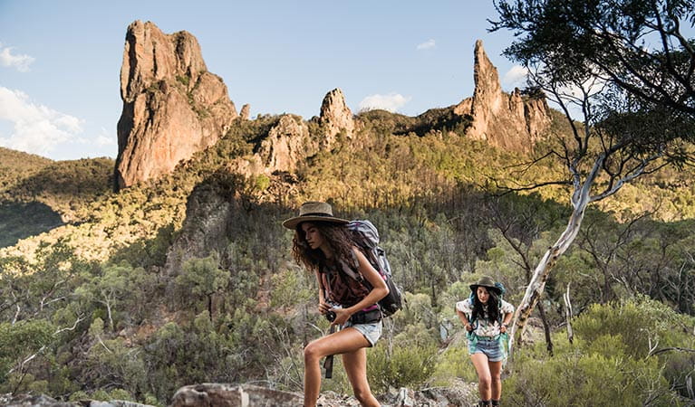
Warrumbungle National Park near Coonabarabran in NSW is Australia’s first Dark Sky Park, making it the perfect spot for stargazing, amateur astronomy and camping under the starriest of skies.
Read more about Warrumbungle National Park
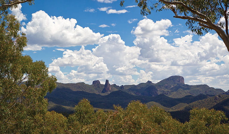
The Breadknife, easily the most recognisable feature within the park, towers 90m above the valley floor and is a symbol of the park’s enduring importance and resilience. The Breadknife and Grand High Tops walk is recognised as one of the best walks in NSW, with close up views of the park's iconic rock formations.
Whether you’re into camping, walking, birdwatching or astronomy, the park's big sky, amazing light and dramatic rock formations make it an outstanding place for amateur and professional photographers.
Wildfires in 2013 marked yet another chapter in this great park’s history. NPWS has worked hard to rebuild its facilities for generations to come. Walking tracks, campgrounds and other visitor sites have been rebuilt with new modern facilities. Drop into the Warrumbungle Visitor Centre for park information or buy a star chart to enjoy our starry nights.
Local alerts
For the latest updates on fires, closures and other alerts in this area, see https://www.nationalparks.nsw.gov.au/visit-a-park/parks/warrumbungle-national-park/local-alerts
Map
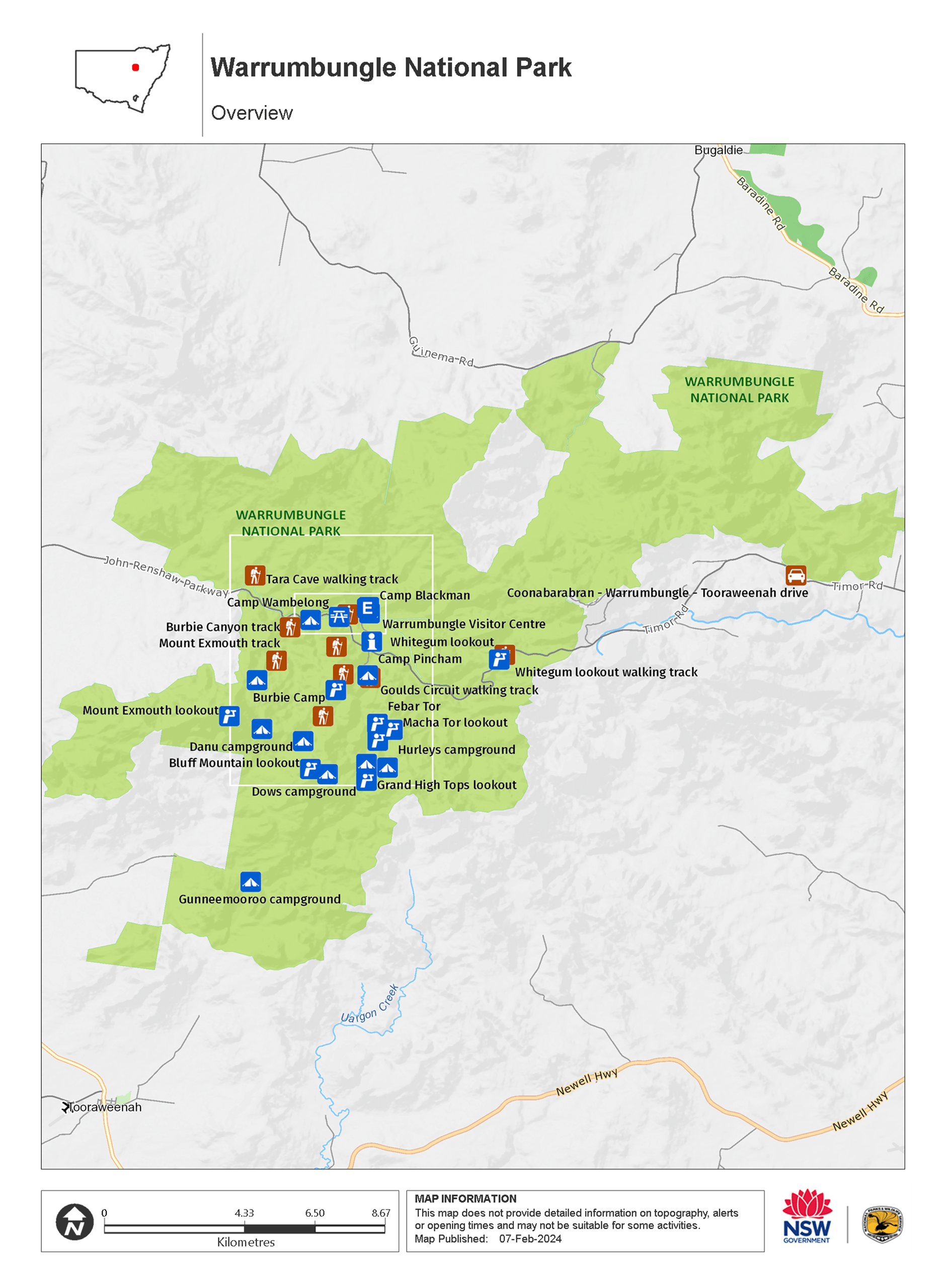
Map
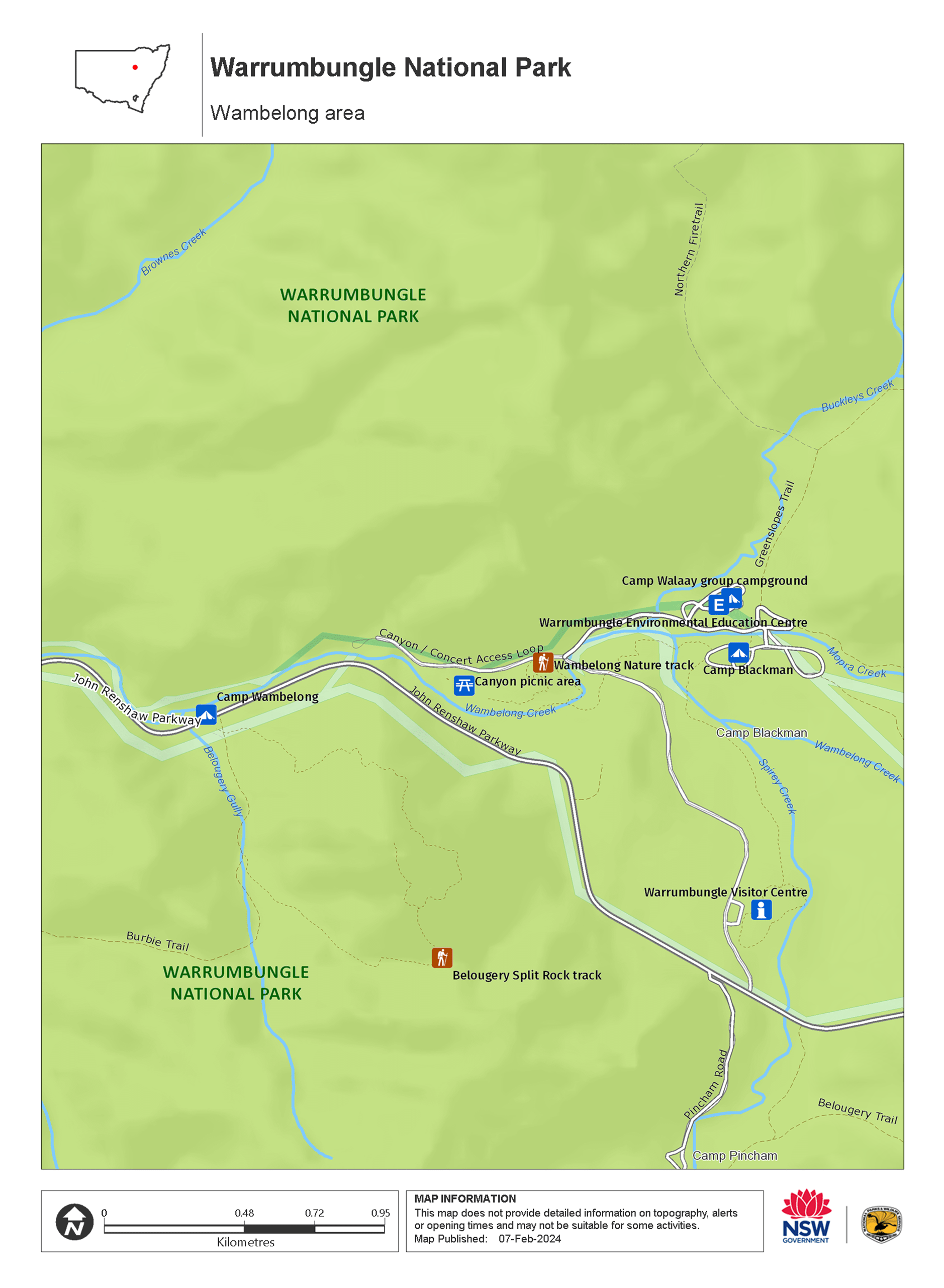
Map
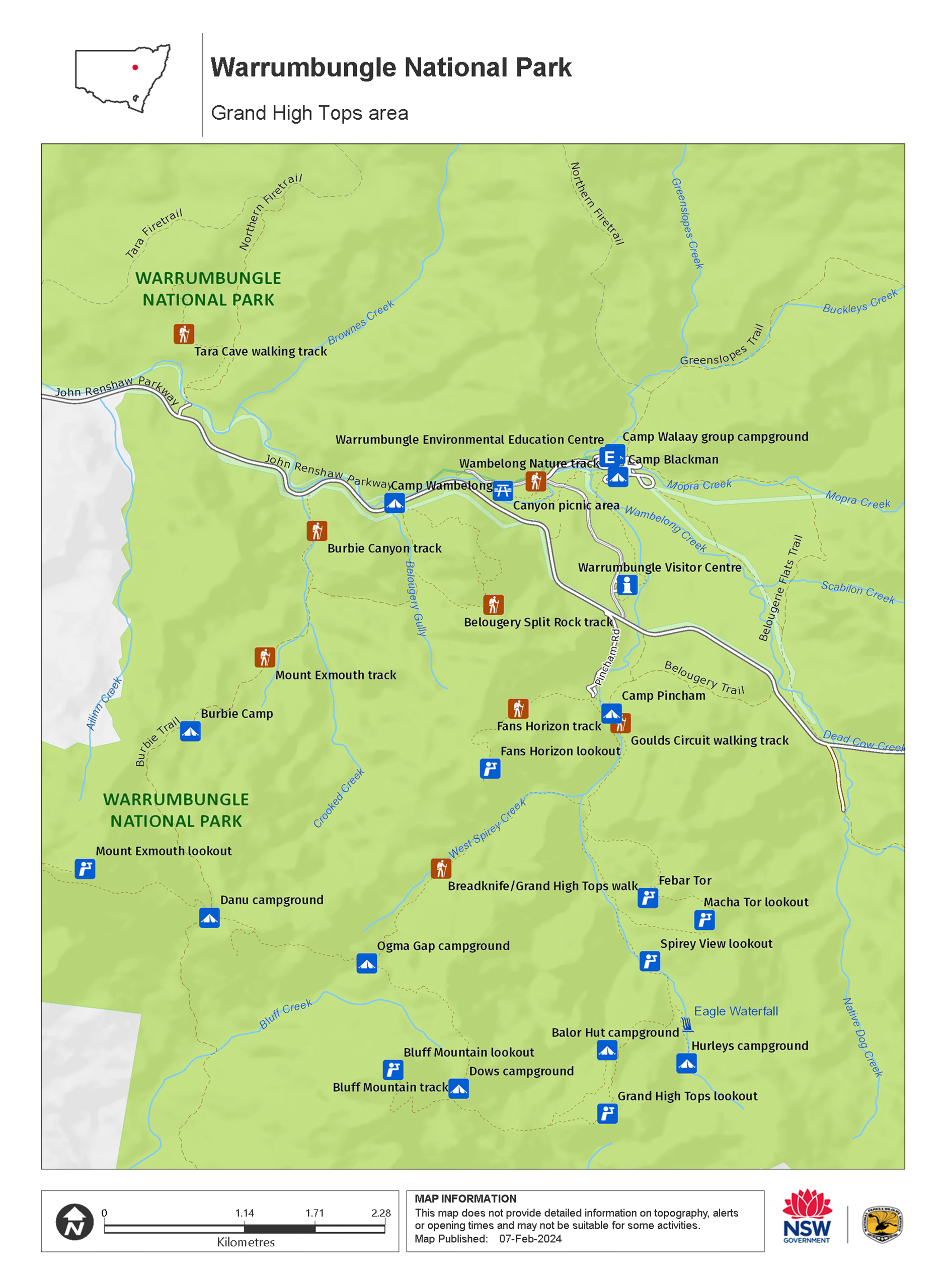
Map legend

Contact
- in the Country NSW region
Warrumbungle National Park is always open but may have to close at times due to poor weather or fire danger.
-
Park entry fees:
$8 per vehicle per day.
Buy annual pass -
-
Warrumbungle NP Visitor Information Centre
02 6825 4364
Contact hours: 9am to 4pm daily. Closed Christmas Day. - 4261 John Renshaw Parkway, Warrumbungle NSW 2828
-
Email: warrumbungle.np@environment.nsw.gov.au
-
Warrumbungle NP Visitor Information Centre
Visitor info
All the practical information you need to know about Warrumbungle National Park.
Getting there and parking
Get driving directions
The turn-off to Warrumbungle National Park is clearly signposted.
From Coonabarabran:
- Take Dalgarno Street west from Newell Highway/John Street
- Turn right onto Namoi Street, then turn left onto Eden Street
- Following signs for Warrumbungle National Park, travel along Timor Road/John Renshaw Parkway for approx. 35km.
- Following the signs within the national park, turn right off John Renshaw Parkway and travel approx. 300m to the visitor centre.
From Gilgandra:
- Take Newell Highway north towards Coonabarabran
- At the brown Tourist Drive 1 sign, turn left off the highway into the village of Tooraweenah. Follow Tourist Drive 1 north through Tooraweenah
- Continue for 26km to the T-intersection at the old Gummin Gummin homestead
- Turn right onto John Renshaw Parkway and continue for 8km, when you will enter the national park.
- Continue along John Renshaw Parkway for approx. 6km more, then turn left off John Renshaw Parkway and travel approx. 300m to the visitor centre.
From Coonamble:
- Take Castlereagh Highway south, and turn left onto King Street.
- Continue along Coonamble-Tooraweenah Road for approx. 68km. Some of this road is unsealed.
- Once within Warrumbungle National Park, continue along John Renshaw Parkway for approx. 6km.
- Turn left off John Renshaw Parkway and travel approx. 300m to the visitor centre.
From Gulargambone:
- Take Gulargambone Road east for approx. 31km, as it becomes John Renshaw Parkway. Some of this road is unsealed.
- Veer right onto Coonamble-Tooraweenah Road. Some of this road is unsealed.
- Once within Warrumbungle National Park, continue along John Renshaw Parkway for approx. 6km.
- Turn left off John Renshaw Parkway and travel approx. 300m to the visitor centre.
Parking Show more
- Bluff Mountain walking track See on map
- Burbie Camp See on map
- Camp Pincham See on map
- Camp Walaay group campground See on map
- Goulds Circuit walking track See on map
- Tara Cave walking track See on map
- Whitegum lookout walking track See on map
Road quality
- Unsealed roads
By bike
Check out the Bicycle information for NSW for more information.
By public transport
For information about public transport options, visit the NSW country transport info website.
Best times to visit
You may experience a great range of temperatures on any day in the park. In summer it's generally hot in the daytime and temperatures often exceed 30C. In contrast, winter can be very cold and the temperature drops below freezing at night. Rainfall is also highly variable, ranging from drought to prolonged wet periods. Less rain falls on the western side of the park than on the eastern side. It rains most from December to February and the annual average rainfall is 720mm. Thunderstorms are common in mid to late summer.
Spring
During early spring wildflowers are in bloom, including a huge variety of golden wattle flowers With a more moderate climate, spring is a great time to get out and camp under the stars .
Weather, temperature and rainfall
Summer temperature
Average
15°C and 30°C
Highest recorded
42.6°C
Winter temperature
Average
0°C and 15°C
Lowest recorded
-9°C
Rainfall
Wettest month
January
Driest month
September
The area’s highest recorded rainfall in one day
176.3mm
Facilities
Amenities
Toilets Show more
- Balor Hut campground
- Camp Blackman
- Camp Pincham
- Camp Walaay group campground
- Camp Wambelong
- Canyon picnic area
- Goulds Circuit walking track
- Gunneemooroo campground
- Tara Cave walking track
- Warrumbungle Environmental Education Centre
- Warrumbungle Visitor Centre
Picnic tables Show more
- Camp Blackman
- Camp Pincham
- Camp Walaay group campground
- Camp Wambelong
- Canyon picnic area
- Warrumbungle Environmental Education Centre
- Warrumbungle Visitor Centre
- Whitegum lookout
- Whitegum lookout walking track
Barbecue facilities Show more
Public phone
Showers
Maps and downloads
Fees and passes
Park entry fees:
$8 per vehicle per day.
- All Parks Pass - For all parks in NSW (including Kosciuszko NP) $190 (1 year) / $335 (2 years)
- Multi Parks Pass - For all parks in NSW (except Kosciuszko) $65 (1 year) / $115 (2 years)
- Country Parks Pass - For all parks in Country NSW (except Kosciuszko) $45 (1 year) / $75 (2 years)
- Single Country Park Pass - For entry to a single park in country NSW (except Kosciuszko). $22 (1 year) / $40 (2 years)
Annual passes and entry fees (https://www.nationalparks.nsw.gov.au/passes-and-fees)
Prohibited
Pets
Pets and domestic animals (other than certified assistance animals) are not permitted. Find out which regional parks allow dog walking and see the pets in parks policy for more information.
Smoking
NSW national parks are no smoking areas.
Visitor centre
-
Warrumbungle Visitor Centre
4261 John Renshaw Parkway, Warrumbungle NSW 2828 - 9am to 4pm daily. Closed Christmas Day.
- 02 6825 4364
Nearby towns
Coonabarabran (24 km)
Coonabarabran is the closest town to the craggy peaks and spires of the Warrumbungle Ranges. Warrumbungle National Park is popular for bushwalking, camping and encountering wildlife amid breathtaking scenery.
Gilgandra (60 km)
Just a 50-minute drive north of Gilgandra are the majestic Warrumbungles - an area of forested ridges, barren spires, deep gorges and walking tracks. Warrumbungle National Park has some excellent day walks, such as the Breadknife and Grand High Tops walk.
Coonamble (95 km)
Coonamble is a delightful country town, the gateway to the wetlands of the Macquarie Marshes and the rugged scenery of Warrumbungle National Park. Nearby are opal fields to the north, and the Pilliga State Forest, with its stands of eucalypts.
Learn more
Warrumbungle National Park is a special place. Here are just some of the reasons why:
Aboriginal dreamtime
Warrumbungle is a Gamilaraay word meaning crooked mountain, and for many thousands of years it has been a spiritual place for the custodians of this land, the Gamilaraay, the Wiradjuri and the Weilwan. The landscape, plants and animals of the park are a constant reminder of its sacred significance to Aboriginal people today. Take an Aboriginal Discovery guided tour to find out more about the Aboriginal cultural heritage.
- Tara Cave walking track Tara Cave walking track is a gentle 3.4km return bushwalk through Warrumbungle National Park, near Coonabarabran. Learn about local Aboriginal culture and experience remarkable views.
Landscape and geology
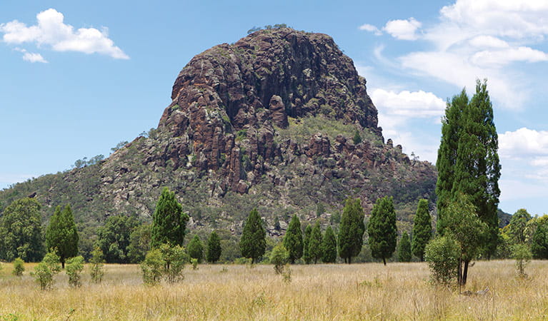
The landscape of Warrumbungle National Park has been shaped by millions of years of volcanic activity and erosion; spend some time looking at Crater Bluff and Belougery Spire and imagine the vents of magma that once erupted to create these formations. Layers of lava and volcanic rock created Mount Exmouth and Mount Woorut just outside the boundary of the park, and Belougery Split Rock and Bluff Mountain are great examples of igneous lava domes. One of the most iconic features in the park, The Breadknife, is a volcanic dyke which stands a massive 90m tall. You can learn more about the park's fascinating geological history, or take a self-guided geology tour, through the NSW GeoTours app.
- Bluff Mountain walking track Bluff Mountain walking track rewards experienced, fit bushwalkers with Warrumbungle National Park’s best views. This very long and challenging steep hike climbs past spectacular rock spires and domes—up to the summit of Bluff Mountain.
- Breadknife and Grand High Tops walk Breadknife and Grand High Tops walk in Warrumbungle National Park, regarded as one of the best walks in NSW, offers close up views of the park’s iconic rock formations.
- Burbie Canyon walking track Burbie Canyon walking track in Warrumbungle National Park offers a gentle 2km stroll through a sandstone gorge, and is particularly popular for birdwatching.
- Coonabarabran - Baradine - Warrumbungle drive Explore the spectacular landscapes, historic towns, picnic spots and walks of the Warrumbungles and Pilliga, near Coonabarabran and Baradine, in NSW.
- Coonabarabran - Warrumbungle - Tooraweenah drive Coonabarabran – Warrumbungle – Tooraweenah drive offers car touring through scenic mountain views with picnicking, walking, and wheelchair accessible facilities in Warrumbungle National Park.
Wish upon a star
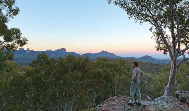
Warrumbungle National Park is Australia’s first Dark Sky Park. Nearby Coonabarabran is known as the 'Astronomy Capital of Australia'. Stargaze from your campsite, or if you want to see right up to the heavens, visit a local observatory. The dramatic mix of volcanic spires and domes, plateaus, forested ridges and tall volcanic dykes are bound to make even the youngest of photographers look good, so whatever you do ‐ don't forget your camera.
- Canyon picnic area Canyon picnic area is a fully accessible, family friendly picnic area in Warrumbungle National Park. Not far from the visitor centre, it features barbecues and tables.
- Warrumbungle Visitor Centre Visitor information is available at the Warrumbungle Visitor Centre, which is now back in its original location. Get great suggestions and tips for walking and camping in Warrumbungle National Park.
- Whitegum lookout Whitegum lookout in Warrumbungle National Park features spectacular views of the landscape and picnic tables. It is wheelchair accessible and an easy walk for children.
Diversity of wildlife
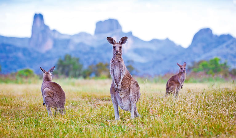
Warrumbungle National Park has a rich diversity of landforms and microclimates, and provides a habitat for hundreds of plant and animal species. Flourishing with wildflowers and unique plants, such as Warrumbungle Range wattle, Warrumbungle star flower, golden cassinia and grey ray flower, the area also has an abundance of rich birdlife, including emus, wedge-tailed eagles and turquoise parrots - just a few of over 190 bird species recorded in the park. If you're lucky, you may also spot wildlife such as the koala, squirrel glider and brush-tailed rock wallaby. Be sure to also keep an eye out for Warrumbungle black rock skink high on the mountains, and lace monitors rustling through the bush.
- Burbie Canyon walking track Burbie Canyon walking track in Warrumbungle National Park offers a gentle 2km stroll through a sandstone gorge, and is particularly popular for birdwatching.
- Whitegum lookout walking track Whitegum lookout walking track is a short, wheelchair-accessible walk in Warrumbungle National Park. Suitable for all ages, it offers remarkable views.
Plants and animals protected in this park
Animals
-
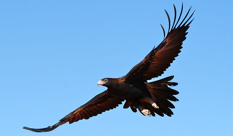
Wedge-tailed eagle (Aquila audax)
With a wingspan of up to 2.5m, the wedge-tailed eagle is Australia’s largest bird of prey. These Australian animals are found in woodlands across NSW, and have the ability to soar to heights of over 2km. If you’re bird watching, look out for the distinctive diamond-shaped tail of the eagle.
-
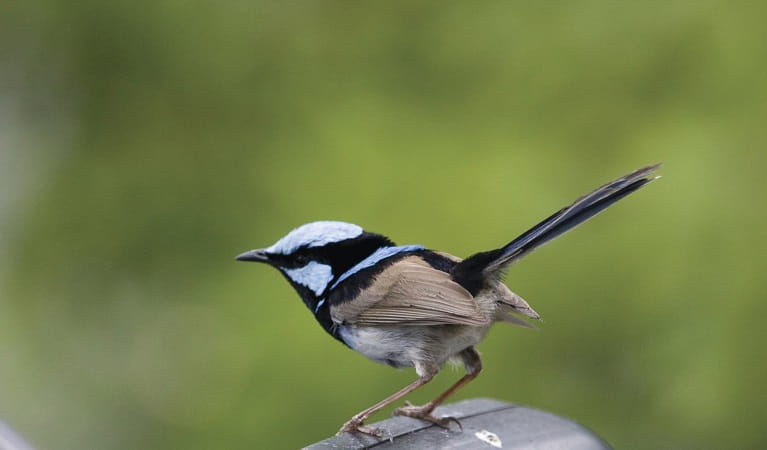
Superb fairy wren (Malurus cyaneus)
The striking blue and black plumage of the adult male superb fairy wren makes for colourful bird watching across south-eastern Australia. The sociable superb fairy wrens, or blue wrens, are Australian birds living in groups consisting of a dominant male, mouse-brown female ‘jenny wrens’ and several tawny-brown juveniles.
-
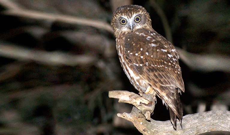
Southern boobook (Ninox novaeseelandiae)
The southern boobook, also known as the mopoke, is the smallest and most common native owl in Australia. With a musical 'boo-book' call that echoes through forests and woodlands, the southern boobook is a great one to look out for while bird watching.
-
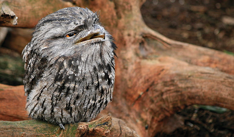
Tawny frogmouth (Podargus strigoides)
Found throughout Australia, the tawny frogmouth is often mistaken for an owl due to its wide, powerful beak, large head and nocturnal hunting habits. The ‘oom oom oom’ call of this native bird can be heard echoing throughout a range of habitats including heath, woodlands and urban areas.
-
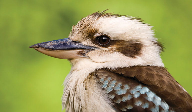
Kookaburra (Dacelo novaeguineae)
Of the 2 species of kookaburra found in Australia, the laughing kookaburra is the best-known and the largest of the native kingfishers. With its distinctive riotous call, the laughing kookaburra is commonly heard in open woodlands and forests throughout NSW national parks, making these ideal spots for bird watching.
Environments in this park
Education resources (1)
What we're doing
Warrumbungle National Park has management strategies in place to protect and conserve the values of this park. Visit the OEH website for detailed park and fire management documents. Here is just some of the work we’re doing to conserve these values:
Preserving biodiversity
NPWS works to protect biodiversity in all parks, and Warrumbungle National Park is no exception. Revegetation programs are ongoing in this park, and can include seed propagation, tree planting, controlled ecological burning, extensive research and monitoring. Fencing and pest management strategies also take place within this park.
Managing weeds, pest animals and other threats
Pests and weeds have a significant impact to the ecosystems within Warrumbungle National Park. NPWS carries out pig, fox, goat, wild dog and weed control as well as risk assessments for new and emerging weeds to protect biodiversity in this park.
Managing fire
NSW is one of the most bushfire prone areas in the world as a result of our climate, weather systems, vegetation and the rugged terrain. NPWS is committed to maintaining natural and cultural heritage values and minimising the likelihood and impact of bushfires via a strategic program of fire research, fire planning, hazard reduction, highly trained rapid response firefighting crews and community alerts.
General enquiries
- National Parks Contact Centre
- 7am to 7pm daily
- 1300 072 757 (13000 PARKS) for the cost of a local call within Australia excluding mobiles
- parks.info@environment.nsw.gov.au
Contact
- in the Country NSW region
Warrumbungle National Park is always open but may have to close at times due to poor weather or fire danger.
-
Park entry fees:
$8 per vehicle per day.
Buy annual pass -
-
Warrumbungle NP Visitor Information Centre
02 6825 4364
Contact hours: 9am to 4pm daily. Closed Christmas Day. - 4261 John Renshaw Parkway, Warrumbungle NSW 2828
-
Email: warrumbungle.np@environment.nsw.gov.au
-
Warrumbungle NP Visitor Information Centre
In this park:
Things to do (26)
- Aboriginal culture (1)
- Adventure sports (1)
- Birdwatching and wildlife encounters (8)
- Cultural heritage (1)
- Educational activities (1)
- Historic heritage (1)
- Other experiences (1)
- Picnics and barbecues (3)
- Road trips and car/bus tours (2)
- Sightseeing (17)
- Swimming (1)
- Visitor centres (1)
- Walking (18)
- Wildflowers (seasonal) (10)