Warrabah National Park
Overview
At Warrabah National Park, near Tamworth and Uralla, you can enjoy camping, bushwalking, fishing, swimming, canoeing, wildlife photography, and birdwatching by Namoi River.
Read more about Warrabah National Park
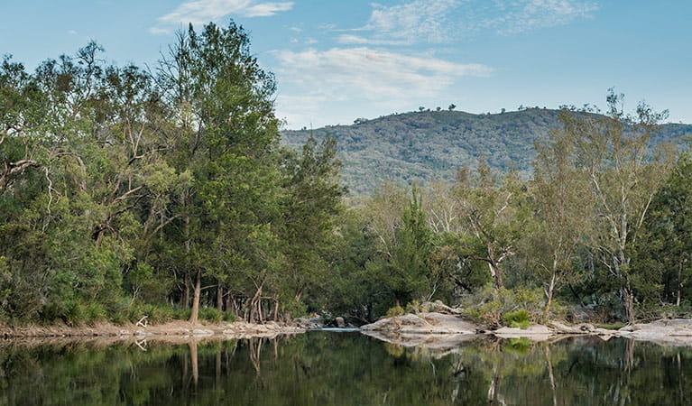
One of the few inland river parks in NSW, beautiful Warrabah National Park, just east of Manilla and north of Tamworth, has an incredibly tranquil atmosphere thanks in large part to the spectacular Namoi River. The park is bisected by over 14km of the river in a dramatic gorge. Massive granite boulders perch high above the valley’s deep, calm pools and the swelling river rapids offer the promise of exciting adventures for intrepid canoeists.
Naturally, most visitors to the park base their exploration of the park around riverside activities, such as swimming, fishing, liloing, and canoeing, or vehicle-based camping, bushwalking and picnicking by the water. The park’s sense of peaceful solitude makes it a wonderful spot for long, relaxed bushwalks, birdwatching, nature photography, and self-reliant camping and hiking.
There’s plenty of space in which to camp and picnic and lots to explore, from the grassy flats beside the river to the towering ridgelines that rise high above it. You’ll find campsites nestled in the bush and a well laid out space designed specifically for scenic picnics by the river, complete with all the conveniences you'd expect.
Local alerts
For the latest updates on fires, closures and other alerts in this area, see https://www.nationalparks.nsw.gov.au/visit-a-park/parks/warrabah-national-park/local-alerts
Contact
- in the Country NSW region
Warrabah National Park is always open but may have to close at times due to fire danger or flooding.
-
-
Armidale office
02 6738 9100
Contact hours: Monday to Friday, 8.30am to 5pm. - 145 Miller Street, Armidale NSW 2350
-
Email: npws.nea@environment.nsw.gov.au
-
Armidale office
-
-
Narrabri office
02 6792 7300
Contact hours: Monday to Friday, 8.30am to 4.30pm. - Level 1, 100 Maitland Street, Narrabri NSW 2390. Accessible via Dewhurst Street.
-
Email: npws.barwon@environment.nsw.gov.au
-
Narrabri office
Visitor info
All the practical information you need to know about Warrabah National Park.
Map
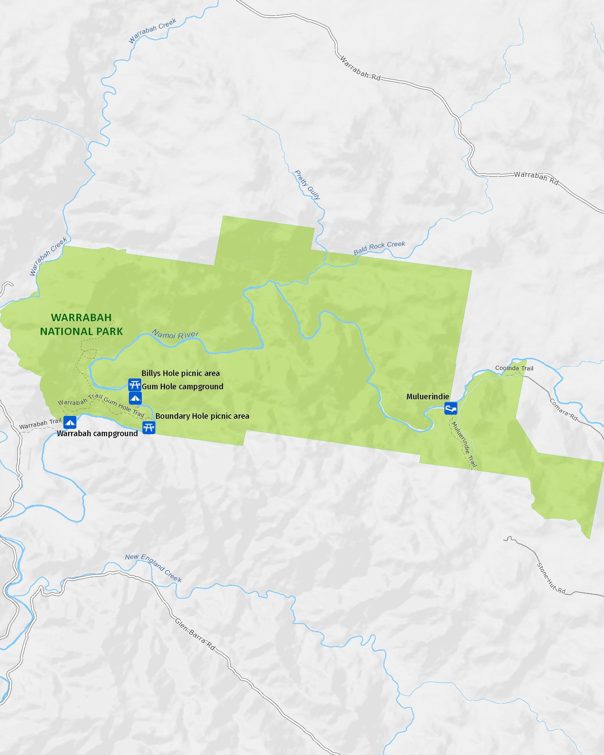
Map legend

Getting there and parking
To get to Warrabah or Gum Hole campgrounds and picnic areas, you’ll need to drive via Manilla.
Don’t use Google Maps to direct you to these campgrounds. It will take you on unsafe, ummarked roads through private property. You can use Google Maps to get you to Manilla only. From Manilla, please follow these directions:
- Travel north out of town across the Namoi River towards Barraba
- About 500m north of the bridge turn right onto Barraba Street
- Continue onto Namoi River Road and follow the signs to Warrabah National Park
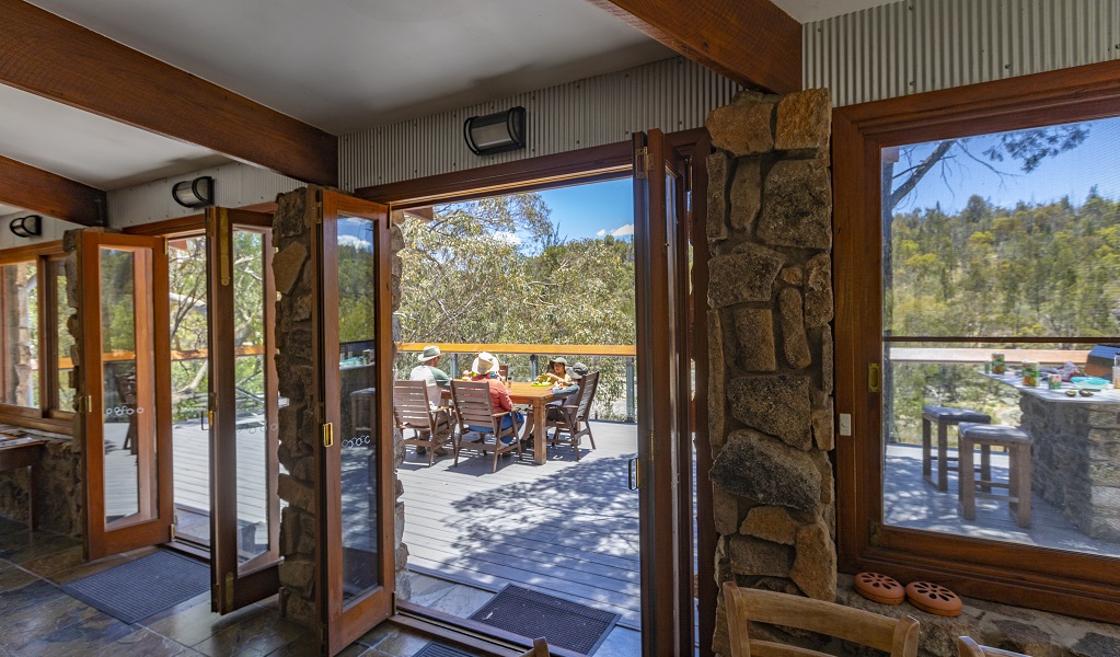
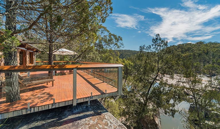
To get to Muluerindie, you’ll need to have a booking.
Muluerindie is located 60km (1hour) west of Uralla, via Retreat Road. Detailed directions will be provided in your booking confirmation, but you can approach from:
- Uralla on the New England Highway
- Manilla (in the west) via Halls Creek Road then onto Stone Hut Road
- Inverell (in the north) through Kingstown via Kingstown Road
- Bendemeer (in the south) via Retreat Road
Parking
- Gum Hole campground and picnic area See on map
- Warrabah campground and picnic area See on map
By bike
Check out the Bicycle information for NSW website for more information.
By public transport
For information about public transport options, visit the NSW country transport info website
Best times to visit
There are lots of great things waiting for you in Warrabah National Park. Here are some of the highlights.
Autumn
Make the most of the cooler days to explore some of the park's more heart-pumping bushwalks.
Spring
A lovely time to enjoy picnicking by the river, indulging in wildlife and nature photography, birdwatching, and bushwalking.
Summer
Cool off from the heat in the lovely Namoi River with a swim and a splash, enjoy a spot of fishing, or take on a bracing canoeing adventure.
Winter
The park is often quiet at this time of year, yet doesn't get too cold, so it's a good opportunity to go bushwalking and birdwatching in solitude.
Weather, temperature and rainfall
Summer temperature
Average
17°C and 32°C
Highest recorded
41.3°C
Winter temperature
Average
0°C and 18°C
Lowest recorded
-9.4°C
Rainfall
Wettest month
January
Driest month
April
The area’s highest recorded rainfall in one day
194.3mm
Facilities
Toilets
Picnic tables
Barbecue facilities
Drinking water
Showers
Maps and downloads
Prohibited
Pets
Pets and domestic animals (other than certified assistance animals) are not permitted. Find out which regional parks allow dog walking and see the pets in parks policy for more information.
Smoking
NSW national parks are no smoking areas.
Nearby towns
Barraba (80 km)
Barraba is a birdwatcher's paradise - spot the rare Regent Honeyeater on one of the region's 14 bird routes, which have fine tree cover and good public access. There are plenty of great spots for bushwalking, such as through remnant rainforest in Mount Kaputar National Park.
Tamworth (83 km)
Tamworth's annual Country Music Festival is the largest music festival in the southern hemisphere and one of the top 10 music festivals in the world, with more than 2,200 events and 400 performances or gigs across 90 venues.
Armidale (179 km)
During autumn the parks and gardens around Armidale show their beautiful colours. Enjoy a drive along the Waterfall Way, stopping at waterfalls and craggy gorges in the rugged countryside.
Learn more
Warrabah National Park is a special place. Here are just some of the reasons why:
Gone fishing
Keen fishers will be delighted at the freshwater fish species that can be caught here, including the delicious Murray cod and freshwater catfish, as well as several smaller species, such as the western carp gudgeon.
Amazing animals
The park is home to plenty of interesting animals, which you'll encounter throughout your visit. You might spot eastern grey kangaroos, common wallaroos and red-necked wallabies in the fields and forests at dawn and dusk. Platypus can be seen on rare occasions splashing along the river in waterholes during the late afternoon too. At night, common brushtail possums and sugar gliders can be caught foraging in the Kurrajong trees. Common reptiles here include lace monitors, southern spotted velvet geckos and red-bellied black snakes. Namoi River even provides habitat for the vulnerable Bell's turtle, which is found only within the Namoi/Gwydir catchment. Be sure to bring your binoculars if you enjoy bird watching because over 120 species of birds have been sighted here, from robins, rosellas and cockatoos to wedge-tailed eagles and wrens, just to name a few.
A river runs through it
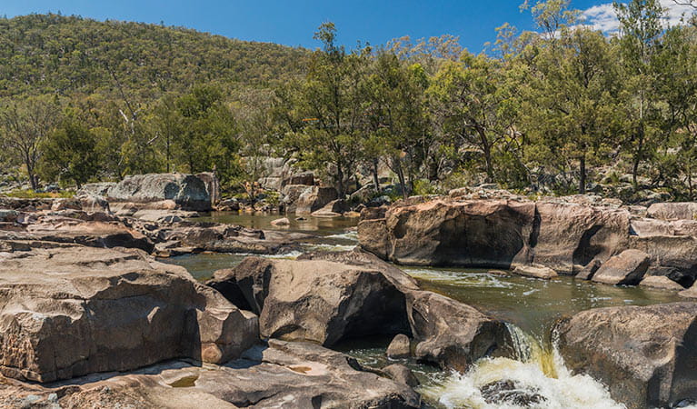
The soothing atmosphere and scenery created by the impressive Namoi River is surpassed by few national parks and must be seen to be fully appreciated. Huge granite boulders tower above the valley's deep, tranquil pools, while the rushing rapids are a highly enjoyable challenge for experienced canoeists.
Education resources (1)
What we're doing
Warrabah National Park has management strategies in place to protect and conserve the values of this park. Visit the OEH website for detailed park and fire management documents.