Cocoparra National Park
Overview
With its dramatic scenic views, Cocoparra National Park is fabulous for bushwalking and birdwatching, and within a half hour drive of Griffith in the Riverina.
Read more about Cocoparra National Park
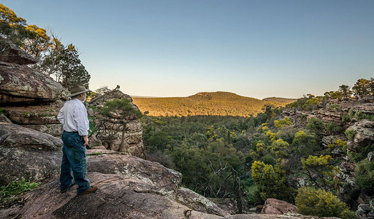
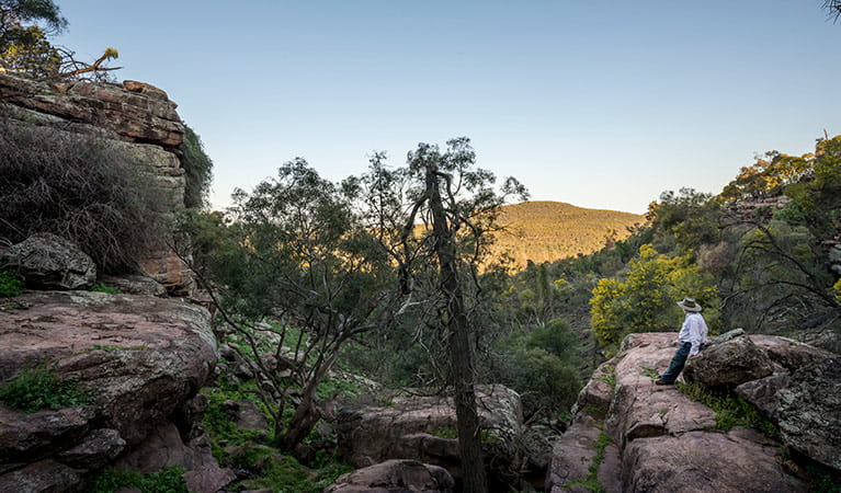
Once inside Cocoparra National Park, the huge sky of the outback is painted with the distinctive Cocoparra Range. This dramatic and rugged place is a haven for bushwalkers, birdwatchers and nature-lovers, with a landscape that’s vividly alive and always changing.
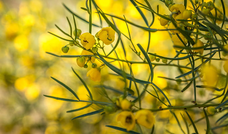
Visit after rain to see the waterfalls and creeks in full flow and come in spring to see the wonderful variety of wildflowers; orchids, wattles and tea tree bring extra vibrancy to the land. Other seasonal delights include the nesting season of the majestic peregrine falcons and the sight of rainbow bee-eaters building their homes in the ground – you’ll know them by their amazing spectrum of colour.
Make sure you take the walking tracks up to the ridge to capture the views of the vast plains and other geological formations. Stay for a bush camp to really appreciate all the park has to offer. It’s an incredibly peaceful place to spend the night.
Local alerts
For the latest updates on fires, closures and other alerts in this area, see https://www.nationalparks.nsw.gov.au/visit-a-park/parks/cocoparra-national-park/local-alerts
Contact
- in the Murray-Riverina region
Cocoparra National Park is always open but may have to close at times due to poor weather or fire danger.
-
-
Griffith office
02 6966 8100
Contact hours: Monday to Friday, 9am to 4pm. Closed 1pm to 2pm. - 200 Yambil Street, Griffith NSW 2680
-
Email: npws.riverina@environment.nsw.gov.au
-
Griffith office
Visitor info
All the practical information you need to know about Cocoparra National Park.
Map
Map legend

Getting there and parking
Get driving directions
From Griffith:
- Travelling east along Burley Griffin Way from town centre, turn left onto Crossing Street.
- Turn right onto Wakaden Street. This becomes Rankin Springs Road, and then Beelbangera Road as you pass through Beelbangera.
- At Yenda, turn left onto Myall Park Road.
- Turn right onto Mount Bingar Road, which will take you into the park.
- Road signs provide directions along the route from Griffith to Cocoparra National Park
Please note that the eastern side of Cocoparra National Park connects to private property. There is no access to the park from Pleasant Valley Road and you will not be able to enter the park from the Eastern Boundary fire trail as this is for park management only.
If you're visiting the park, please enter from the western side, via Barrys Scenic Drive or Mount Bingar Road.
Parking
- Spring Hill picnic area See on map
- Store Creek picnic area See on map
- The Pines picnic area See on map
By bike
Check out the Bicycle information for NSW website for more information.
By public transport
For information about public transport options, visit the NSW country transport info website.
Best times to visit
There are lots of great things waiting for you in Cocoparra National Park. Here are some of the highlights.
Autumn
Camp at Woolshed Flat while the days are still long and warm enough to explore the walking tracks and the cool nights are pleasant for sitting and watching the sun set Keep an eye out for the autumn greenhood, an early flowering orchid. .
Spring
Take Jacks Creek walking track to see gorgeous spring flowers, including orchids, daisies, wattles and tea-trees. Watch the first rainbow bee-eaters arrive to build nests in the ground. Their brilliant colours are dazzling. Climb Mount Brodgen to look out over the plains and the tree line of Murrumbidgee River .
Winter
Winter rains bring the creeks and falls to life, and the blue-tinged cypress pine trees contrast against the red rocks beautifully after wet weather. The mosses and lichens on Falcon Falls walking track are also renewed with the seasonal rains Wattles begin to flower and their glorious colour will brighten up a cold day .
Weather, temperature and rainfall
Summer temperature
Average
15°C and 33°C
Highest recorded
44.7°C
Winter temperature
Average
3°C and 17°C
Lowest recorded
–4.8°C
Rainfall
Wettest month
October
Driest month
December
The area’s highest recorded rainfall in one day
111.3mm
Facilities
Amenities
Toilets
Picnic tables
Barbecue facilities
Maps and downloads
Prohibited
Pets
Pets and domestic animals (other than certified assistance animals) are not permitted. Find out which regional parks allow dog walking and see the pets in parks policy for more information.
Smoking
NSW national parks are no smoking areas.
Nearby towns
Griffith (27 km)
Griffith is at the heart of the vast Murrumbidgee Irrigation Area and produces about 60% of the grapes grown in the State. Today, there are more than a dozen wineries in the district with world-famous names. Visit De Bortoli or Hanwood and stock up on local produce, such as jams, preserves or pasta sauces.
Leeton (58 km)
Become a twitcher for a day and spot migratory birds, rare species and waterfowl that travel en masse to Fivebough Wetlands. More than 170 species migrate here throughout the year so it's no surprise that the annual Australian Bird Fair is a major drawcard.
Narrandera (87 km)
Narrandera is a Country NSW National Trust Urban Conservation Area located at the crossroads of the Newell and Sturt highways. This tranquil rural town in the heart of Riverina features tree-lined streets, fine historic buildings and many historic attractions.
Learn more
Cocoparra National Park is a special place. Here are just some of the reasons why:
Dramatic rock formations
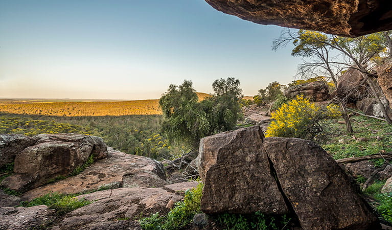
Conserving an important area of native vegetation, Cocoparra National Park stands out amid the surrounding plains and farmlands with its rugged ranges and spectacular scenery. Deep narrow valleys, folded and eroded rock faces and delightful waterfalls mean that the view is always changing. For a dramatic overview of the plains, take Jacks Creek or Mount Brogden walking tracks. The rugged, craggy landscape of the Cocoparra Range produces a great variety of habitats. You’ll find woodlands and forests occupied by white cypress pine, Dwyer’s mallee gum, kurrajong, yellow box and many more during your bushwalks. If you’re a budding botanist, you’ll love the delicate orchids and spring wildflowers.
- Jacks Creek walking track Jacks Creek walking track threads through a sheltered gorge and upon ridge tops. You’ll enjoy scenic views, plentiful birdwatching and diverse habitats.
- Store Creek walking track Explore interesting rock formations on Store Creek walking track, only 30 minutes from Griffith. The track is a birdwatcher’s paradise and a wildflower wonderland in spring.
- Woolshed Falls walking track Woolshed Falls walking track, near Griffith, is located in Cocoparra National Park, close to Woolshed Flat campground. It’s great for walking with kids.
Ancient Aboriginal sites
This is Wiradjuri country, and the many Aboriginal sites within Cocoparra National Park suggest intensive use during winter and spring when food resources became scarce along rivers, with surface water available in the protected valleys of the range. The name 'Cocoparra' comes from the Aboriginal 'cocupara', or kookaburra.
A haven for birds
This is a mecca for birdwatchers, with many resident and migratory species recorded here. Look out for the locally-threatened glossy-black cockatoo drinking from dams at dusk or quietly feeding on the seeds of the drooping she-oak. You may also see the many endangered woodland birds such as the hooded robin, speckled warbler, varied sittella, grey-crowned babbler, diamond firetail or shy heathwren. You can also visit the nesting grounds of the peregrine falcon at Falcon Falls.
- Falcon Falls walking track Take Falcon Falls walking track for bushwalking past waterfalls and for spectacular woodland birdwatching, including magnificent peregrine falcons during nesting season.
- Mount Brogden walking track Visit Mount Brogden walking track in Cocoparra National Park, near Griffith, for some excellent birdwatching, and enjoy Murrumbidgee River views.
- Store Creek walking track Explore interesting rock formations on Store Creek walking track, only 30 minutes from Griffith. The track is a birdwatcher’s paradise and a wildflower wonderland in spring.
Education resources (1)
What we're doing
Cocoparra National Park has management strategies in place to protect and conserve the values of this park. Visit the OEH website for detailed park and fire management documents.