Paroo-Darling National Park
Visitor info
All the practical information you need to know about Paroo-Darling National Park.
Getting there and parking
Get driving directions
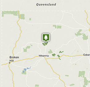
To get to the Peery section of Paroo-Darling National Park:
- From the Barrier Highway at Wilcannia:
- Travel north along the sealed road to White Cliffs (90km)
- Then travel east along the unsealed Mandalay Road (20km)
- Or from Wilcannia, travel north up the unsealed Wanaaring Road (80km)
To get to the Wilga section of Paroo-Darling National Park:
- From Wilcannia travel east along the Barrier Highway to the Tilpa Road turn off (5km)
- Then travel north east along the unsealed East Tilpa Road (35km)
Park entry points
- Wannaring Road access See on map
Parking
- Paroo-Darling Visitor Centre, White Cliffs See on map
- Peery Lake picnic area See on map
Road quality
- Unsealed roads
Vehicle access
- 2WD vehicles
Weather restrictions
- Dry weather only
By bike
Check out the Bicycle information for NSW website for more information.
Best times to visit
It's a haven for waterbirds, so the best time of year to visit is when Peery Lake is full. Spring is a good time to see emu chicks and at other times you may see kangeroos, eagles and falcons.
Weather, temperature and rainfall
Summer temperature
Average
23°C and 36°C
Highest recorded
48.6°C
Winter temperature
Average
5°C and 19°C
Lowest recorded
-3.3°C
Rainfall
Wettest month
January
Driest month
September
The area’s highest recorded rainfall in one day
173.2mm
Facilities
Toilets
Picnic tables
Barbecue facilities
Maps and downloads
Prohibited
Pets
Pets and domestic animals (other than certified assistance animals) are not permitted. Find out which regional parks allow dog walking and see the pets in parks policy for more information.
Smoking
NSW national parks are no smoking areas.
Contact
- in the Outback NSW region
Paroo-Darling National Park is always open but may have to close at times due to extreme weather or fire danger.
-
-
Broken Hill office
08 8084 2880
Contact hours: Monday to Friday, 8.30am to 4.30pm. Closed 1pm to 2pm. - 183 Argent Street, Broken Hill NSW 2880
-
Email: npws.westdarling@environment.nsw.gov.au
-
Broken Hill office
-
-
Paroo-Darling Visitor Centre, White Cliffs
Contact hours: Monday to Friday, 8.30am to 4.30pm. - 2 Johnston Street, White Cliffs NSW 2836
-
Email: npws.westdarling@environment.nsw.gov.au
-
Paroo-Darling Visitor Centre, White Cliffs
Visitor centre
-
Paroo-Darling Visitor Centre, White Cliffs
2 Johnston Street, White Cliffs NSW 2836 - Monday to Friday, 8.30am to 4.30pm.
Nearby towns
White Cliffs (73 km)
Opals were discovered in the White Cliffs area as early as 1884. The town's first store and hotel opened in 1892, and miners soon arrived to dig their fortunes out of the ground. Make sure you buy an opal keepsake from one of the world's most unusual towns.
Wilcannia (167 km)
The small historic town of Wilcannia is located on the famous Darling River in the NSW outback. The nearby remote Mutawintji National Park offers a uniquely Australian experience, with its historic Aboriginal sites and captivating rugged desert terrain.
Broken Hill (360 km)
About 10 km from Broken Hill, in the middle of the Living Desert Reserve, is Sundown Hill, the site of the Living Desert Sculptures. Follow the easy walking trail that takes you past these beautiful sandstone sculptures, even more striking in this desert setting.