Biamanga National Park
Visitor info
All the practical information you need to know about Biamanga National Park.
Getting there and parking
Get driving directions
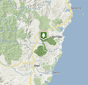
Biamanga National Park is 23km north of Bega.
To get there from Bega:
- Drive north-east along Dr George Mountain Road
- Turn left on to Mumbulla Creek Road at the Biamanga Cultural Area sign
- Continue along Mumbulla Creek Road and turn left at the intersection with Tee Ridge Road, to remain on Mumbulla Creek Road
- Turn right on to Mumbulla Creek Falls Road and follow the signs to the Biamanga Cultural Area carpark
Please note: there is no access to Biamanga National Park from the Princes Highway via Clarkes Road, as this is private property.
Park entry points
- Mumbulla Creek See on map
Parking
- Biamanga Cultural area See on map
By bike
Check out the Bicycle information for NSW website for more information.
By public transport
Biamanga is accessible via bus to Bega. For information about public transport options, visit the NSW country transport info website.
Best times to visit
There are lots of great things waiting for you in Biamanga National Park. Here are some of the highlights.
Spring
See the chefs cap correa flowers hanging from their stems, and bring binoculars for some excellent birdwatching opportunities.
Summer
Escape the heat of the sun by settling down for a picnic in the cool shade near Mumbulla Creek Falls. Goannas are regular visitors in the warmer months.
Weather, temperature and rainfall
Summer temperature
Average
13.9°C and 26.6°C
Highest recorded
44°C
Winter temperature
Average
2.3°C and 17.3°C
Lowest recorded
-8.1°C
Rainfall
Wettest month
March
Driest month
August
The area’s highest recorded rainfall in one day
454.2mm
Facilities
Maps and downloads
Prohibited
Pets
Pets and domestic animals (other than certified assistance animals) are not permitted. Find out which regional parks allow dog walking and see the pets in parks policy for more information.
Smoking
NSW national parks are no smoking areas.

Contact
- in the South Coast region
Biamanga National Park is always open, but may have to close at times due to poor weather or fire danger.
-
-
Narooma office
02 4476 0800
Contact hours: Monday to Friday, 9am to 4pm. Office open by appointment only. Closed public holidays. - 10 Graham Street, Narooma NSW 2546
-
Email: npws.eurobodalla@environment.nsw.gov.au
-
Narooma office
Nearby towns
Bega (24 km)
With its forests, lush pastures and a coastline sculpted into a succession of wonders by the sea, the Sapphire Coast is a perfect holiday destination at any time of the year. Set in a valley at the junction of the Bega and Brogo rivers and surrounded by rich dairy country, Bega is a handsome, historic town that's the rural centre of the Sapphire Coast and gateway to the lush Bega Valley. Visit the Bega Cheese Heritage Centre, housed in a faithful reproduction of the original, tells the story of cheese-making production in the area.
Bermagui (57 km)
Bermagui is a colourful port, famous for its deep-sea fishing. It's on the estuary of the Bermagui River, close to national parks.
Eden (76 km)
Eden is a historic whaling town, ideal for a whale-watch tour. It's built around a promontory that juts into Twofold Bay.