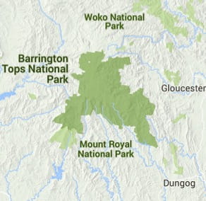
Barrington Tops National Park
Visitor info
All the practical information you need to know about Barrington Tops National Park.
Getting there and parking
Get driving directions
Southern Barrington Tops:
- From Dungog, take Chichester Dam Road for about 10km before turning left on Salisbury Road.
- After about 27km, you'll reach the Lagoon Pinch to Williams River precinct of the park.
Eastern Barrington Tops:
- From Gloucester, take Bucketts Way before turning right onto Gloucester Tops Road.
- After about 30km, you’ll reach the Gloucester River precinct of the park, and further on you’ll find the Gloucester Tops precinct.
Northern Barrington Tops:
From Gloucester:
- Take Thunderbolts Way, which becomes Scone Road and Barrington Tops Forest Road.
- After about 45km, you'll reach Cobark picnic area.
- Continue on for other sites within Polblue and Devils Hole precinct of the park.
From Scone:
- Take Gundy Road, then Hunter Road to Moonan Flat.
- Just past Moonan Flat turn right onto Moonan Brook Road.
- After about 2km, turn left onto Barrington Tops Forest Road.
- You can reach the Barrington Tops precinct by turning left onto Barrington trail south from Barrington Tops Forest Road.
Please note: The condition of the gravel roads in Barrington Tops National Park can vary depending on weather and level of use. This includes Barrington Tops Forest Road, which at times can be corrugated with potholes.
Be prepared for variable road conditions at all times, and drive carefully according to conditions (this includes reducing speed).
For more information about road conditions in the area, contact Gloucester Visitor Information Centre on 1800 802 692, the Gloucester office on (02) 6538 5300, the Scone Visitor Information Centre on (02) 6540 1300, or the Scone office on (02) 6540 2300.
Park entry points Show more
- Barrington Tops access See on map
- Burraga Swamp picnic area See on map
- Gloucester Tops access See on map
- Jerusalem Creek bottom carpark See on map
- Polblue Ridge access See on map
- Salisbury Road access See on map
Parking Show more
- Cobark Park picnic area See on map
- Edwards Swamp walking track See on map
- Gloucester Falls picnic area See on map
- Gloucester Tops picnic area See on map
- Honeysuckle picnic area See on map
- Junction Pools campground See on map
- Little Murray campground See on map
By bike
Check out the Bicycle information for NSW website for more information.
By public transport
For information about public transport options, visit the NSW Country Transport website.
Best times to visit
There are lots of great things waiting for you in Barrington Tops National Park. Here are some of the highlights.
Autumn
Take to the park's walking tracks to make the most of cooler and drier daytime weather.
Spring
Look out for ground orchids and other wildflowers along the Polblue Swamp walking track.
Summer
Look out for the eastern water dragon basking on rocks around the streams.
Facilities
Toilets Show more
- Aeroplane Hill walking track
- Devils Hole lookout walk and picnic area
- Edwards Swamp walking track
- Gloucester Falls picnic area
- Gloucester River campground and picnic area
- Honeysuckle Forest track
- Honeysuckle picnic area
- Jerusalem Creek picnic area
- Junction Pools campground
- Little Murray campground
- Polblue campground and picnic area
- Williams River picnic area
- Wombat Creek campground
Picnic tables Show more
- Cobark Park picnic area
- Devils Hole lookout walk and picnic area
- Gloucester Falls picnic area
- Gloucester River campground and picnic area
- Gloucester Tops picnic area
- Honeysuckle Forest track
- Honeysuckle picnic area
- Jerusalem Creek picnic area
- Lagoon Pinch picnic area
- Little Murray campground
- Polblue campground and picnic area
- Williams River picnic area
Barbecue facilities Show more
Maps and downloads
Prohibited
Pets
Pets and domestic animals (other than certified assistance animals) are not permitted. Find out which regional parks allow dog walking and see the pets in parks policy for more information.
Smoking
NSW national parks are no smoking areas.

Contact
- in the North Coast and Country NSW regions
Barrington Tops National Park is always open but may have to close at times due to poor weather or fire danger.
-
-
Gloucester office
02 6538 5300
Contact hours: Monday to Friday, 8.30am to 4.30pm. - 59 Church Street, Gloucester NSW 2422
-
Email: npws.barringtontops@environment.nsw.gov.au
-
Gloucester office
-
-
Scone office
02 6540 2300
Contact hours: Monday to Friday, 8.30am to 4.30pm. - 19 Hayes Street, Scone NSW 2337
-
Email: npws.barringtontops@environment.nsw.gov.au
-
Scone office
Nearby towns
Dungog (20 km)
Dungog is a country town with character, backed by magnificent rolling hills, national parks and state forests. It's in the heart of dairy and beef cattle country.
Gloucester (39 km)
Famous for gold deposits and the bushranger Captain Thunderbolt, Gloucester is located in the north Hunter region, east of Barrington Tops. The nearby state forests and national parks are ideal for walking, camping and outdoor adventure sports.
Scone (72 km)
Nestled in the picturesque Upper Hunter, Scone is known as the horse capital of Australia.