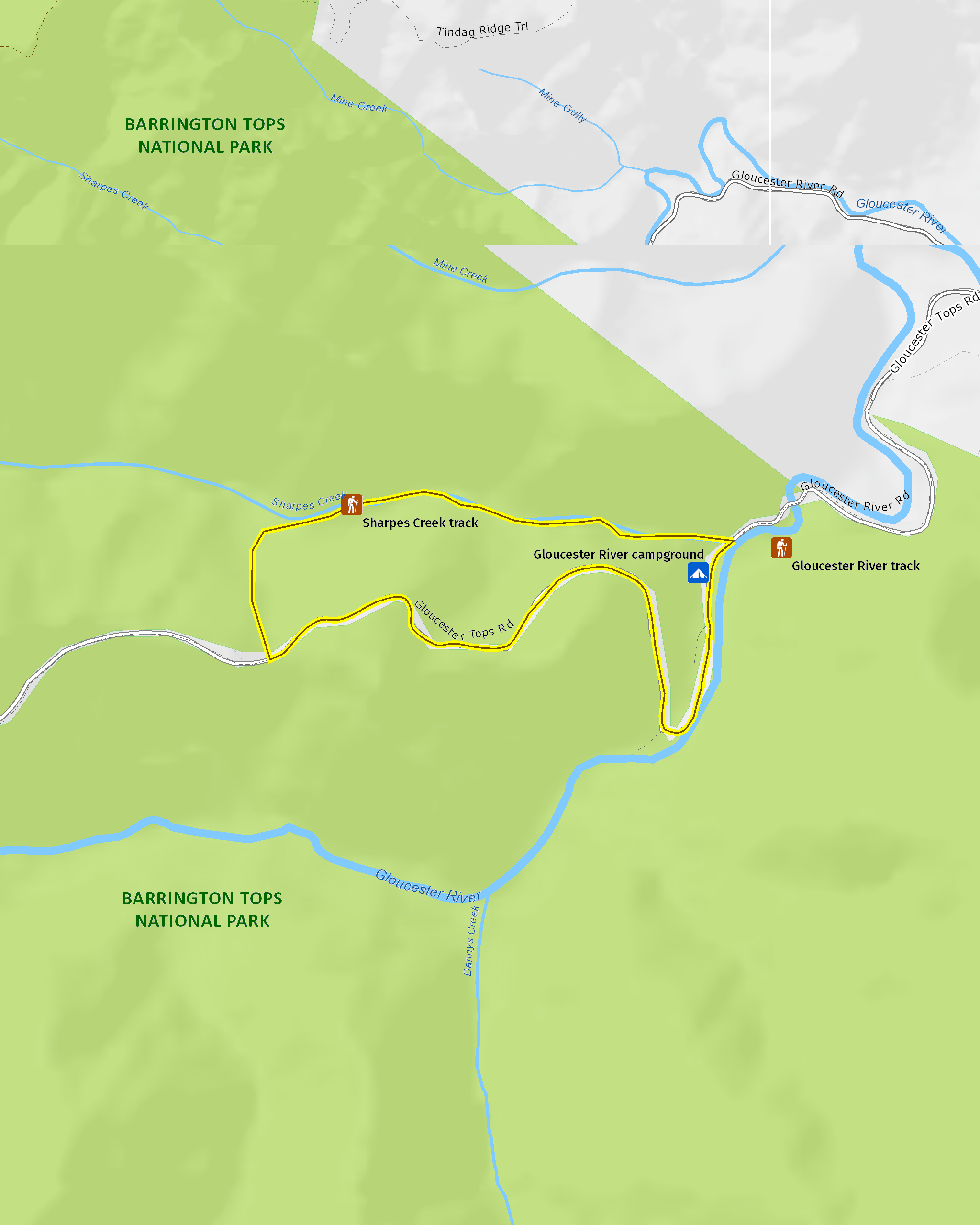
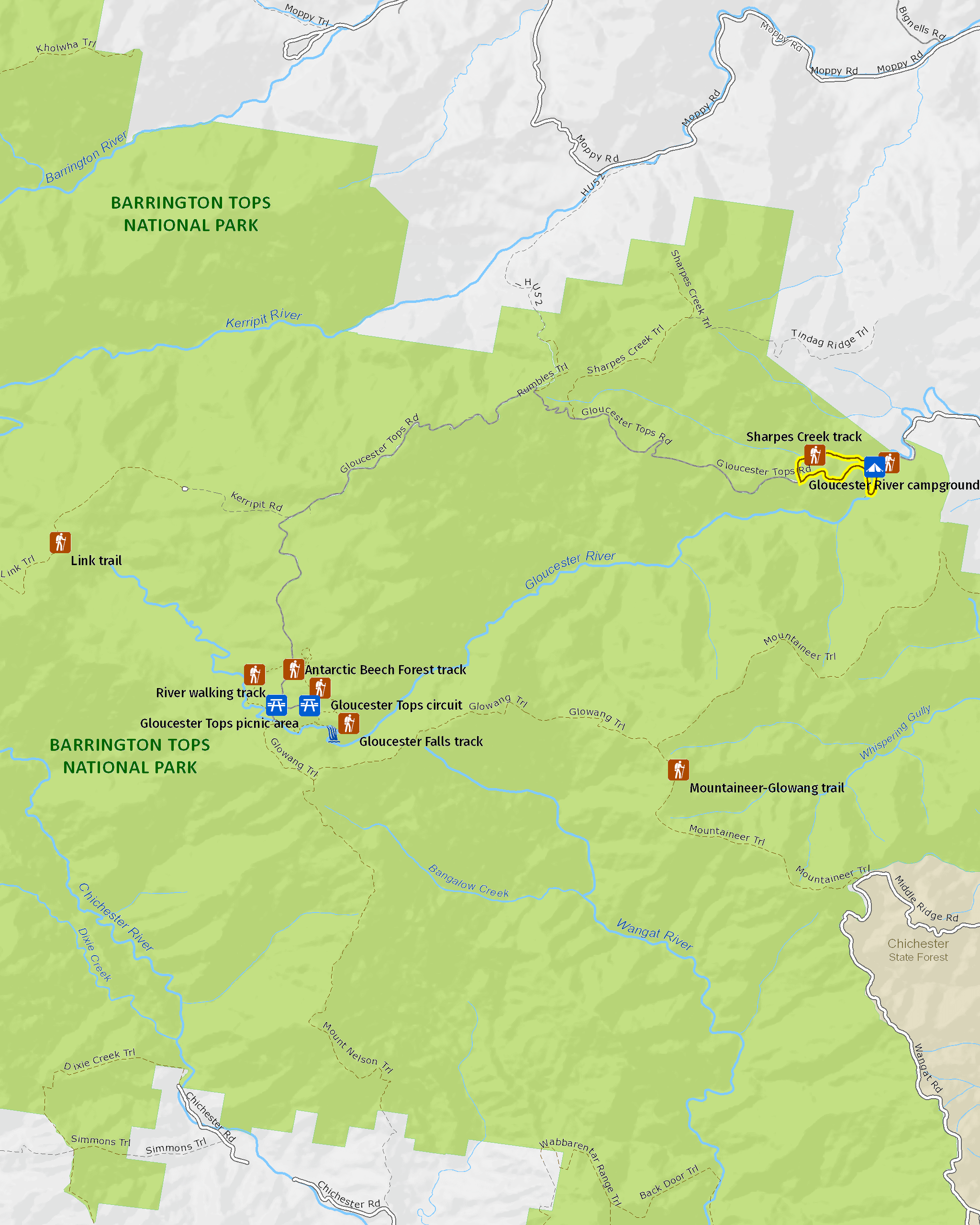
Sharpes Creek walking track
Barrington Tops National Park
Overview
Moderately difficult, Sharpes Creek walking track features rainforest, scenic river views, wildlife, and birdwatching in Barrington Tops National Park near Gloucester.
- Distance
- 4.5km loop
- Time suggested
- 1hr 30min - 2hrs 30min
- Grade
- Grade 4
- Trip Intention Form
-
It's a good idea to let someone know where you're going. Fill in a trip intention form to send important details about your trip to your emergency contact.
- What to
bring - Drinking water, sunscreen, hat, sturdy shoes
- Please note
- If retracing your steps, the walk is 3km return. If opting to walk back via the road, it will be a harder track of 4.5km.
- The heart-shaped leaves of the rainforest giant stinging tree can inflict a painful sting, so be cautious, particularly with children.
- It’s a good idea to bring a topographic map, compass and GPS.
- Check the weather before you set out as the road to Gloucester River and Gloucester Tops may be inaccessible during periods of wet weather
- Toilets and picnic facilities are located at Gloucester River campground
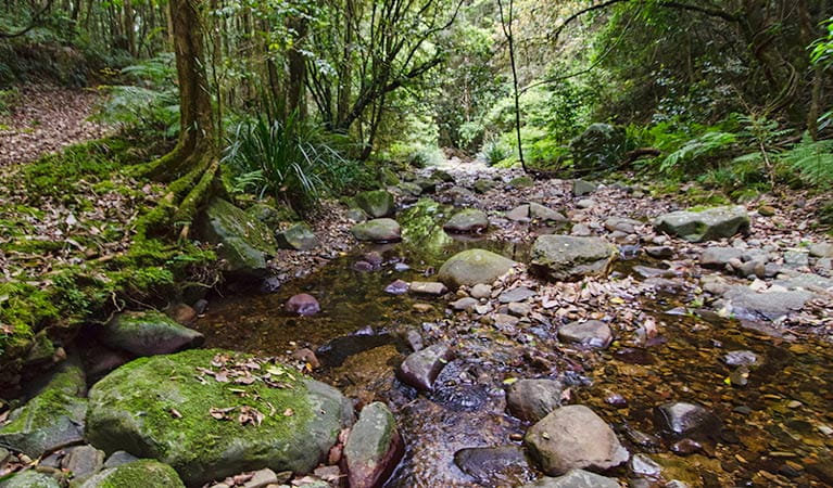
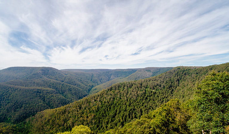
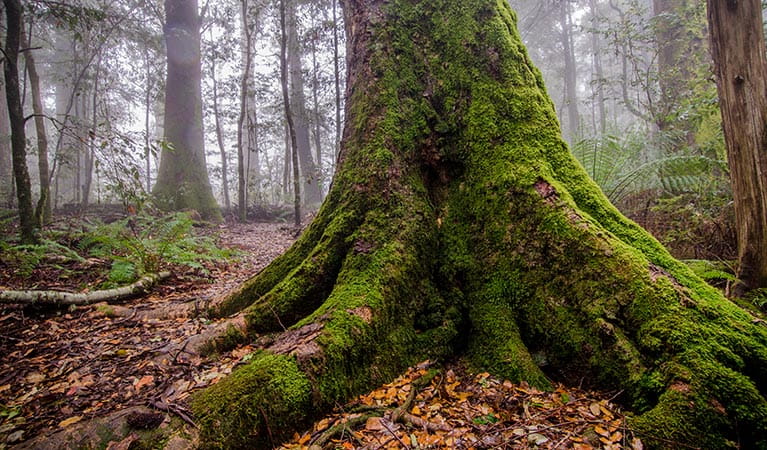
An invigorating walk to enliven the senses, moderate Sharpes Creek walking track combines an environment of river, rainforest and gums with excellent wildlife and birdwatching. It's truly a great adventure for friends or family on a camping holiday, in the river country of Barrington Tops National Park near Gloucester River campground.
You’ll cross the creek several times, so keep an eye out for platypus and eastern water dragons. Smooth dark lumps of basalt stand out in the creek bed, carried down from the slopes above, creating an eye catching hump in the river. The track winds up through the valley as lush rainforest gives way to drier eucalypt forest.
Soak in the scenic views of the canopy and beyond as Sydney blue gums soar overhead. You may see rare rufous fantails or golden whistlers flitting among the trees. Retrace your steps or opt for the steep climb up to the road, lined with huge grass trees. For a longer loop add in the Gloucester River walking track then round off your day with a refreshing swim and a hearty barbecue beside the river.
Map
Map
Map legend

Local alerts
For the latest updates on fires, closures and other alerts in this area, see https://www.nationalparks.nsw.gov.au/things-to-do/walking-tracks/sharpes-creek-walking-track/local-alerts
General enquiries
- National Parks Contact Centre
- 7am to 7pm daily
- 1300 072 757 (13000 PARKS) for the cost of a local call within Australia excluding mobiles
- parks.info@environment.nsw.gov.au
Park info
- in Barrington Tops National Park in the North Coast and Country NSW regions
Barrington Tops National Park is always open but may have to close at times due to poor weather or fire danger.
Visitor info
All the practical information you need to know about Sharpes Creek walking track.
Track grading
Features of this track
Distance
4.5km loop
Time
1hr 30min - 2hrs 30min
Quality of markings
Clearly sign posted
Experience required
Some bushwalking experience recommended
Gradient
Very steep
Steps
Occasional steps
Quality of path
Rough track, many obstacles
Getting there and parking
Sharpes Creek walking track starts from Gloucester River campground in the Gloucester Tops precinct of Barrington Tops National Park. To get there:
- From Bucketts Way, between Gloucester and Stroud.
- Turn into Gloucester Tops Road and continue to Gloucester River campground
Parking
Parking is available at Gloucester River campground.
Best times to visit
There are lots of great things waiting for you in Barrington Tops National Park. Here are some of the highlights.
Autumn
Take to the park's walking tracks to make the most of cooler and drier daytime weather.
Spring
Look out for ground orchids and other wildflowers along the Polblue Swamp walking track.
Summer
Look out for the eastern water dragon basking on rocks around the streams.
Maps and downloads
Permitted
Fishing
A current NSW recreational fishing licence is required when fishing in all waters.
Prohibited
Pets
Pets and domestic animals (other than certified assistance animals) are not permitted. Find out which regional parks allow dog walking and see the pets in parks policy for more information.
Smoking
NSW national parks are no smoking areas.
Learn more
Sharpes Creek walking track is in Barrington Tops National Park. Here are just some of the reasons why this park is special:
World Heritage-listed rainforests
The rainforests in Barrington Tops National Park are part of the Gondwana Rainforests of Australia World Heritage Area; the most extensive strip of diverse rainforest anywhere on earth. The World Heritage Area is a direct window into the past and the future, providing a link to the ancient pre-human world and a stunning and irreplaceable record of life on our planet. You can explore the rainforest on one of the park's many walking tracks, like the Honeysuckle Forest track, the Rocky Crossing walk or the Antarctic Beech Forest track. Listen out for the lyrebird whose mimicking calls ring out through the rainforest.
- Antarctic Beech Forest walking track Antarctic Beech Forest walking track offers rainforest, cascades, scenic views, and birdwatching in Barrington Tops National Park, near Gloucester.
- Careys Peak walking track Easy Careys Peak walking track offers picnicking, scenic views, birdwatching, and historic heritage in the sub-alpine region of Barrington National Park, near Scone.
- Cobark Park picnic area Take a break at Cobark Park picnic area to plan your adventures in the plateau region of Barrington Tops National Park—1 hour from Gloucester.
An ancient landscape
Barrington Tops National Park and the adjoining State Conservation Area are the traditional land of several Aboriginal groups, including the Worimi and Biripi people, the Gringai clan of the Worimi people and Wonnarua people. The rainforests of Barrington Tops offered a wealth of resources for Aboriginal people, including many edible fruits, like the native cherry, lilly pilly and figs. Today, the history of Aboriginal people in Barrington Tops is recorded in oral history and in the presence of Aboriginal sites. Barrington Tops National Park protects ancient campsites, scarred trees and sacred ceremonial places.
A dramatic wilderness
Most of Barrington Tops National Park is declared wilderness; large, natural areas of land that, together with their native plants and animal communities, remain essentially unchanged by modern human activity. Wilderness areas in NSW represent the largest, most pristine natural areas within NSW - the last of Australia's wild and untamed places. The edges of the wilderness area of Barrington Tops are easily accessible; some of the most spectacular views in the park are from Careys Peak and Devils Hole and Thunderbolts lookouts. You'll notice the varied textures of the forest below you, with the ranges of the Barrington Wilderness running east and south from the plateau like the fingers of an outstretched hand.
- Barrington Tops and beyond tag-a-long 4WD tour Get off the beaten track with As the Crow Flies 4WD Tours for an exciting tag-along adventure in Barrington Tops National Park, near Gloucester.
- Barrington trail Take the challenge of the Barrington trail, a 4WD trail in Barrington Tops National Park. Open between October and May every year, plan your 4WD camping holiday now.
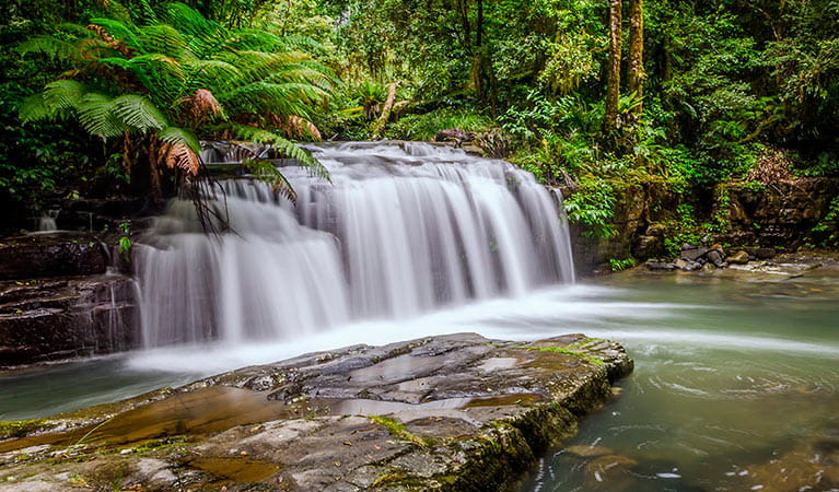
- Gloucester Tops circuit Walk through snow gum woodland and ancient rainforest to lookouts and waterfalls, along the Gloucester Tops circuit. This 8km loop combines 3 popular and scenic walks in Barrington Tops National Park.
- Majestic Barrington mountain bike tours Enjoy spectacular scenery as you cycle through Barrington Tops National Park and beyond on this supported mountain bike tour with Aussie Bike or Hike, near Gloucester.
- Rocky Crossing walk Rocky Crossing walk along Williams River offers scenic rainforest views, wildlife and birdwatching on a long easy track in Barrington Tops National Park, near Dungog.
Plants and animals protected in this park
Animals
-
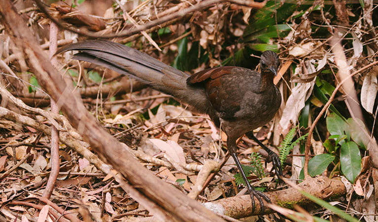
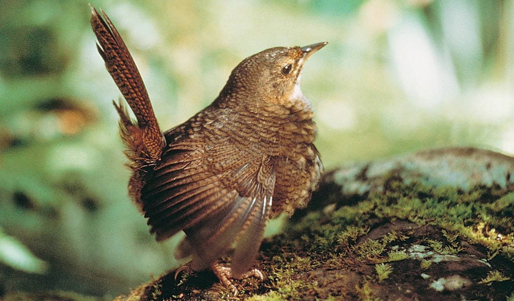
Superb lyrebird (Menura novaehollandiae)
With a complex mimicking call and an elaborate courtship dance to match, the superb lyrebird is one of the most spectacular Australian animals. A bird watching must-see, the superb lyrebird can be found in rainforests and wet woodlands across eastern NSW and Victoria.
-
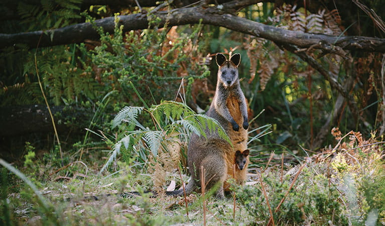
Swamp wallaby (Wallabia bicolor)
The swamp wallaby, also known as the black wallaby or black pademelon, lives in the dense understorey of rainforests, woodlands and dry sclerophyll forest along eastern Australia. This unique Australian macropod has a dark black-grey coat with a distinctive light-coloured cheek stripe.
-
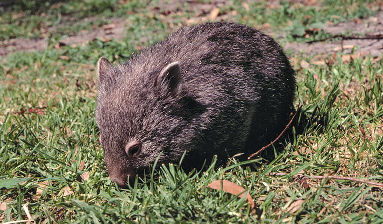
Bare-nosed wombat (Vombatus ursinus)
A large, squat marsupial, the Australian bare-nosed wombat is a burrowing mammal found in coastal forests and mountain ranges across NSW and Victoria. The only other remaining species of wombat in NSW, the endangered southern hairy-nosed wombat, was considered extinct until relatively recently.
-
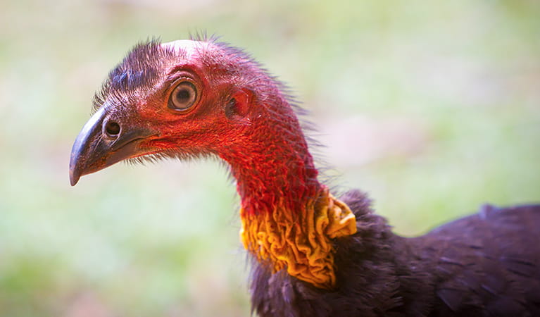
Australian brush turkey (Alectura lathami)
The Australian brush turkey, also known as bush or scrub turkey, can be found in rainforests along eastern NSW. With a striking red head, blue-black plumage and booming call, these distinctive Australian birds are easy to spot while bird watching in several NSW national parks.
-
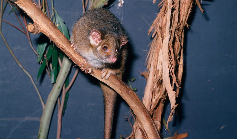
Common ringtail possum (Pseudocheirus peregrinus)
Commonly found in forests, woodlands and leafy gardens across eastern NSW, the Australian ringtail possum is a tree-dwelling marsupial. With a powerful tail perfectly adapted to grasp objects, it forages in trees for eucalypt leaves, flowers and fruit.
-
Rufous scrub-bird (Atrichornis rufescens)
The vulnerable rufous scrub-bird is a small, ground-foraging bird that lives only in isolated rainforest areas of south-eastern Australia.