Rocky Point walking track
Yuraygir National Park
Overview
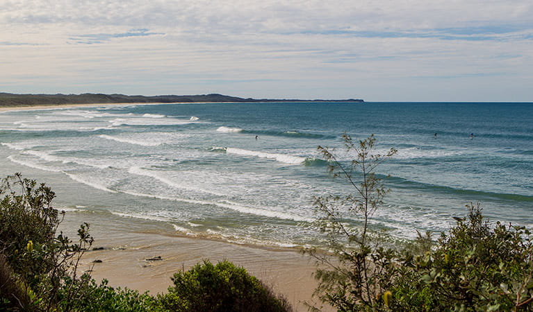
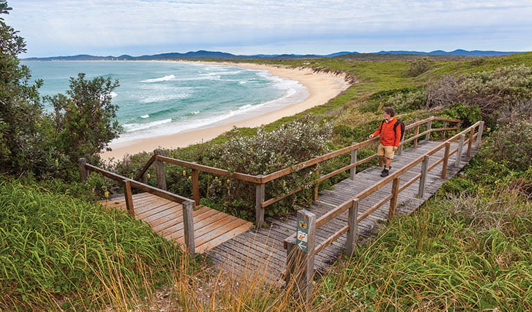
Rocky Point walking track is an easy walk, with spectacular coastal views and plenty of great vantage points for whale watching, making it an ideal family day out.
- Where
- Yuraygir National Park in North Coast
- Accessibility
- No wheelchair access
- Distance
- 1.8km return
- Time suggested
- 30min - 1hr 30min
- Grade
- Grade 3
- Entry fees
- Park entry fees apply
- What to
bring - Drinking water, hat, sunscreen
- Please note
- Check the weather before you set out and ensure you're well prepared. Weather can be unpredictable and extreme in this area.
If you’re looking to experience this spectacular stretch of pristine coastline in an hour or two, Rocky Point walking track is the perfect choice.
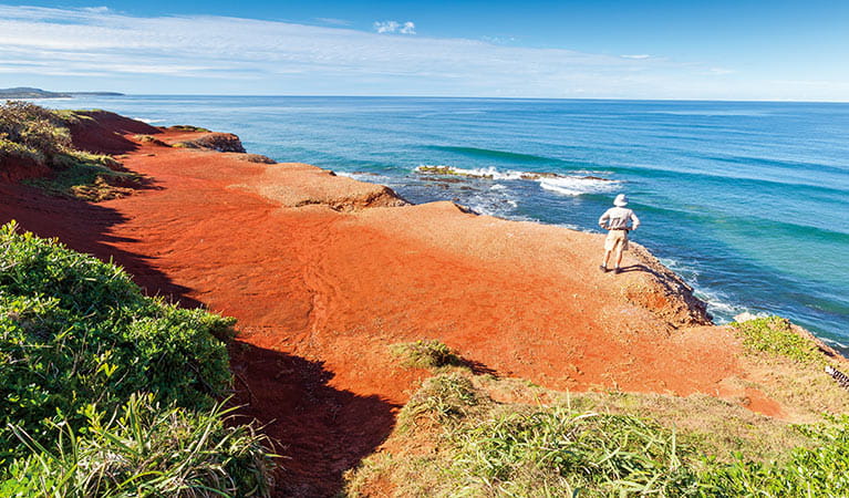
This short walk offers outstanding examples of Yuraygir’s stunning coastal landscape, with beautiful views of sandy beaches and rocky headlands. It’s an easy walk, suitable for all ages and fitness levels, making it a perfect family day trip.
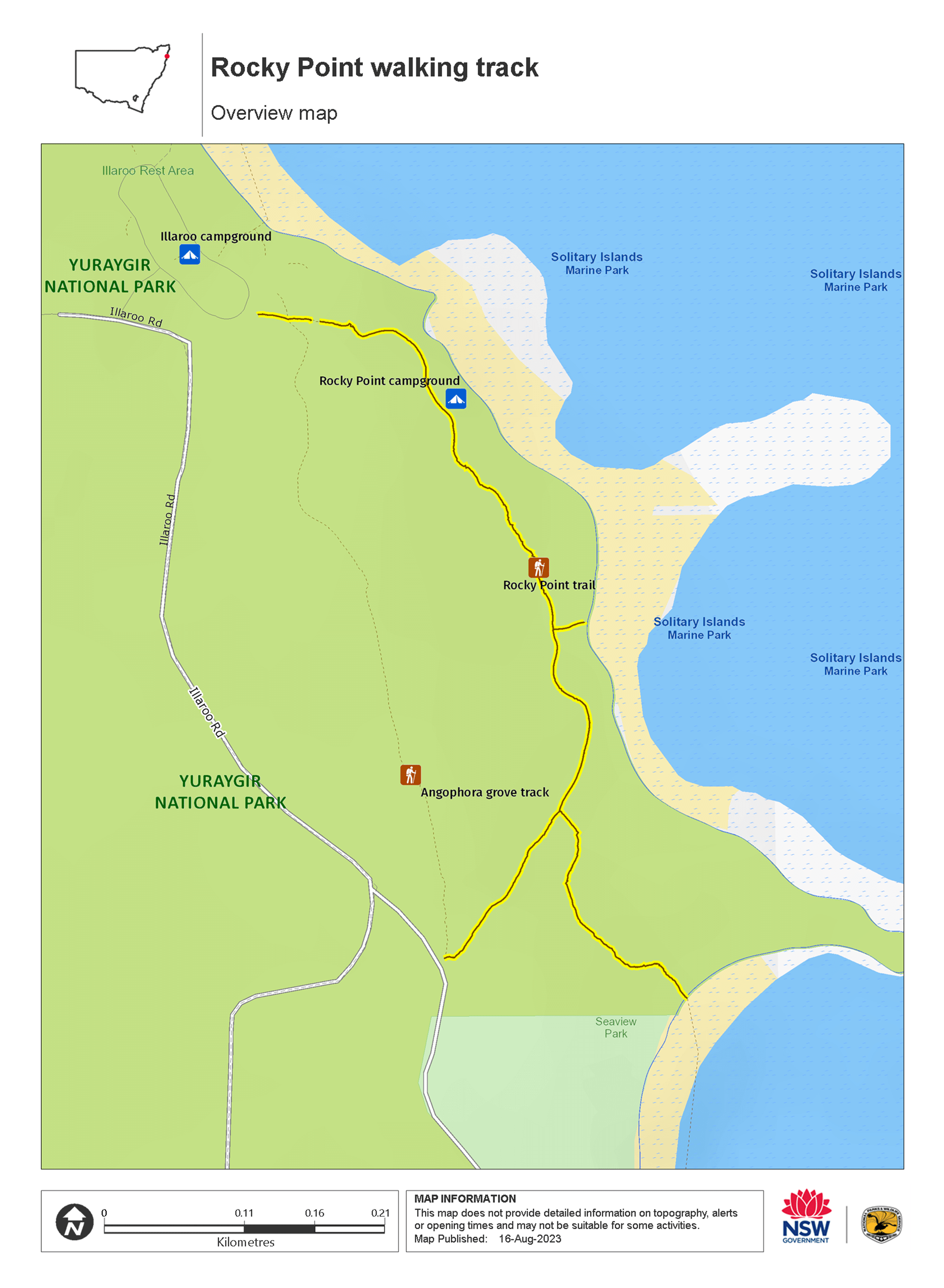
Starting at Illaroo South picnic area, you’ll have several walking tracks to choose from. Follow the track signs to enjoy wide coastal views, intimate forest shades or sandy beaches.
For birdwatchers, be sure to pack your binoculars as this is a great area to see coastal birds such as ospreys and brahminy kites. In winter, enjoy whale watching as you admire the incredible humpback whales on their annual migration. And if you're looking for somewhere to pitch your tent, this track passes both Illaroo campground and Rocky Point campground.
Map
Map legend

Local alerts
For the latest updates on fires, closures and other alerts in this area, see https://www.nationalparks.nsw.gov.au/things-to-do/walking-tracks/rocky-point-walking-track/local-alerts
General enquiries
- National Parks Contact Centre
- 7am to 7pm daily
- 1300 072 757 (13000 PARKS) for the cost of a local call within Australia excluding mobiles
- parks.info@environment.nsw.gov.au
Park info
- in Yuraygir National Park in the North Coast region
Yuraygir National Park is always open but may have to close at times due to poor weather or fire danger.
-
Park entry fees:
$8 per vehicle per day.
Buy annual pass.
Visitor info
All the practical information you need to know about Rocky Point walking track.
Track grading
Features of this track
Distance
1.8km return
Time
30min - 1hr 30min
Quality of markings
Clearly sign posted
Experience required
No experience required
Gradient
Short steep hills: There are short, steep hills, especially at the start of the walk.
Quality of path
Formed track: The track is 1m-wide formed hard-packed sand, with many uneven sections due to plants, rocks and tree roots.
Steps
Occasional steps: Close to the start of the walk, there's a steep uphill section with 52 steps and then a downhill section with 55 steps. The steps are timber, uneven and shallow, with a corded handrail.
Further along the track, there's a side path with another 23 timber steps.
Getting there and parking
Rocky Point walking track is in the Minnie Water precinct of Yuraygir National Park. To get there:
- Follow Pacific Highway approximately 10km south of Grafton
- Turn left at the Wooli turn-off and follow the signs to Wooli
- Approximately 5.5km north of Wooli, turn left onto Minnie Water Road.
- Follow the signs to Illaroo campground from Minnie Water Village
- Illaroo South picnic area is located 800m north of Minnie Water Village
Parking
Parking is available in a bitumen seal carpark at Illaroo South picnic area, where this walk begins. It can be a busy place on the weekend, so parking might be limited.
Best times to visit
There are lots of great things waiting for you in Yuraygir National Park. Here are some of the highlights.
Autumn
Autumn is the perfect time of year to go beach fishing along the park's coastline.
Spring
The park's heathlands provide a spectacular display of wildflowers. Check them out on your choice of walking track, including the Wilsons Headland walk and, of course, the Yuraygir coastal walk.
Summer
Visit in summer to make the most of the park's countless beaches and waterways. Swim, surf or snorkel – cooling sea breezes provide welcome relief in hot weather.
Winter
Plan a winter trip to go whale watching. The sight of migrating whales swimming north to warmer waters is second-to-none, and there are magnificent viewing points at Red Cliffs lookout and Brooms Head.
Weather, temperature and rainfall
Summer temperature
Average
20°C and 26°C
Highest recorded
42.5°C
Winter temperature
Average
9°C and 20°C
Lowest recorded
2.7°C
Rainfall
Wettest month
March
Driest month
September
The area’s highest recorded rainfall in one day
300mm
Facilities
There's an accessible flush toilet and picnic tables at Illaroo South picnic area where this walk begins.
Maps and downloads
Accessibility
Disability access level - no wheelchair access
Rocky Point walking track may be challenging for people with reduced mobility:
- Near the start of the walk, there's a steep uphill section with 52 steps and then a downhill section with 55 steps. The steps are timber, uneven and shallow, with a corded handrail that doesn't fully support a person's weight.
- Further along the track, there's a side path with another 23 timber steps.
- The walk has short, steep hills, especially at the start.
- The track is hard-packed sand, with many uneven sections due to plants, rocks and tree roots.
There's an accessible flush toilet at Illaroo South picnic area where this walk begins. The toilet block is set along a bitumen seal pathway and has a timber walkway with handrails leading to the entrance.
Permitted
Fishing
A current NSW recreational fishing licence is required when fishing in all waters.
Prohibited
Pets
Pets and domestic animals (other than certified assistance animals) are not permitted. Find out which regional parks allow dog walking and see the pets in parks policy for more information.
Smoking
NSW national parks are no smoking areas.
Learn more
Rocky Point walking track is in Yuraygir National Park. Here are just some of the reasons why this park is special:
A watery wonderland
The park not only boasts a superb coastline but also features rivers, lakes and estuaries, so swimmers and snorkelers are spoilt for choice. Remember your fishing rod - the waters off the park are excellent for jewfish and groper, and Sandon River is among the state's most popular fishing spots. If surfing is your thing, you can't beat the legendary Angourie Surfing Reserve - it hosts what's arguably Australia's best right-hand point break. Yuraygir is also a paddler's paradise, its sheltered waterways provide the ideal setting for canoeing, kayaking and boating.
- Angourie Bay picnic area After surfing or swimming at the Clarence Coast’s famous Angourie Headland, stop off at the scenic Angourie Bay picnic area for a tasty picnic lunch with the family.
- Wooli to Red Rock walking track Wooli to Red Rock walking track, part of Yuraygir coastal walk, is a moderate hiking route with river crossings, scenic coastal views and great opportunities for birdwatching.
Important landscapes
When you visit Yuraygir, you're entering one of the most diverse bioregions in Australia. Wander past age-old coastal landforms, littoral rainforest, eucalypt forest, woodland and wetlands - much of which simply wouldn't be there without the park's protection. Pay a visit to Shelley Headland to see the state's most significant remaining example of grassy clay heath.
- Angourie to Brooms Head walking track Angourie to Brooms Head walking track, part of Yuraygir coastal walk, is a hiking route offering scenic lookouts and opportunities for beach walking, birdwatching, and seasonal whale watching.
- Yuraygir coastal walk Hike the multi-day Yuraygir coastal walk on the Clarence Coast near Yamba. You’ll find loads of places for whale watching, snorkelling and swimming, with overnight stops at beach campgrounds.
- Yuraygir guided treks with Home Comforts Hiking Home Comforts Hiking offers guided treks of Yuragir coastal walk with overnight accommodation in 4 charming coastal villages. It’s a great way to explore this beautiful coastline near Yamba and Coffs Harbour.
Precious and protected
At Yuraygir, you can see some of the country’s most vulnerable native wildlife up close, such as squirrel gliders and eastern grass owls. See if you can spot a rufous bettong, a rarely-seen rabbit-sized marsupial also know as the rufous rat-kangaroo. Or even the shy Queensland blossom-bat, Australia’s smallest fruit bat. The threatened green and golden bell frog is one of the 25 amphibians within Yuraygir – likely to be found around swamps, lagoons and flood plains. Keep an eye out for coastal emus, once so prevalent and now, sadly an endangered species with fewer than 100 left in the park.
- Wilsons Headland walking track The easy Wilsons Headland walking track is ideal for whale watching along the Clarence Coast. Starting at Boorkoom campground, the hiking track offers scenic coastal views.
- Yuraygir coastal walk Hike the multi-day Yuraygir coastal walk on the Clarence Coast near Yamba. You’ll find loads of places for whale watching, snorkelling and swimming, with overnight stops at beach campgrounds.
Treasured culture
The landscape of Yuraygir National Park has been, and remains, the Country of Aboriginal groups. Generations of Yaegl and Gumbaynggirr People camped, fished and held ceremonies here and numerous areas remain of strong spiritual significance to the Aboriginal community. Take the Freshwater Walk and view the most impressive pandanus palms - this important Gumbaynggirr ceremonial plant was used to weave neckbands, dillybags and baskets.
- Brooms Head to Illaroo walking track Brooms Head to Illaroo walking track, part of Yuraygir coastal walk, is a hiking route with river crossings, beach walking, scenic coastal views and birdwatching opportunities.
Plants and animals protected in this park
Animals
-
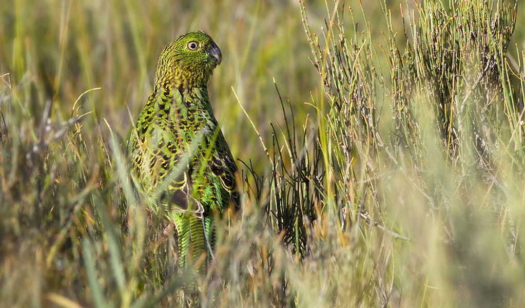
Eastern ground parrot (Pezoporus wallicus wallicus)
The eastern ground parrot is a beautiful, ground-dwelling native bird that lives in low heathland habitat along the NSW North and South coasts and escarpments. It’s listed as a vulnerable species in NSW.
-
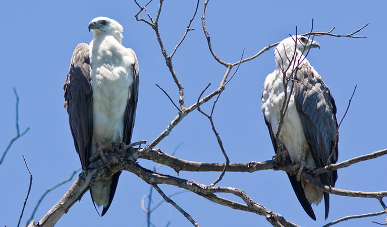
White-bellied sea eagle (Haliaeetus leucogaster)
White-bellied sea eagles can be easily identified by their white tail and dark grey wings. These raptors are often spotted cruising the coastal breezes throughout Australia, and make for some scenic bird watching. Powerful Australian birds of prey, they are known to mate for life, and return each year to the same nest to breed.
-
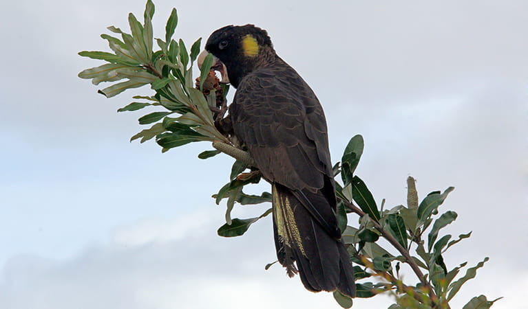
Yellow-tailed black cockatoo (Calyptorhynchus funereus)
The yellow-tailed black cockatoo is one of the largest species of parrot. With dusty-black plumage, they have a yellow tail and cheek patch. They’re easily spotted while bird watching, as they feed on seeds in native forests and pine plantations.
-
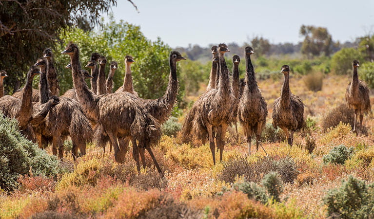
Emu (Dromaius novaehollandiae)
The largest of Australian birds, the emu stands up to 2m high and is the second largest bird in the world, after the ostrich. Emus live in pairs or family groups. The male emu incubates and rears the young, which will stay with the adult emus for up to 2 years.
-
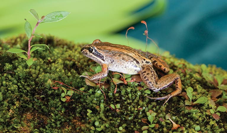
Brown-striped frog (Lymnastes peronii)
One of the most common frogs found in Australia, the ground-dwelling brown-striped frog lives in ponds, dams and swamps along the east coast. Also known as the striped marsh frog, this amphibian grows to 6.5cm across and has a distinctive ‘tok’ call that can be heard all year round.
-
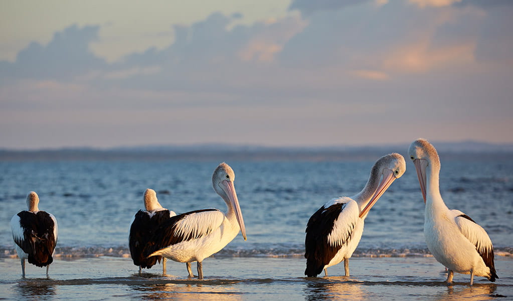
Australian pelican (Pelecanus conspicillatus)
The curious pelican is Australia’s largest flying bird and has the longest bill of any bird in the world. These Australian birds are found throughout Australian waterways and the pelican uses its throat pouch to trawl for fish. Pelicans breed all year round, congregating in large colonies on secluded beaches and islands.
Plants
-
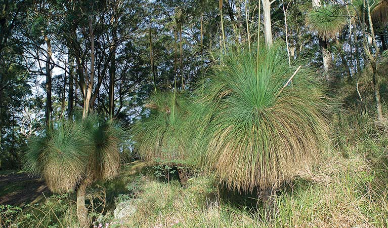
Grass tree (Xanthorrea spp.)
An iconic part of the Australian landscape, the grass tree is widespread across eastern NSW. These Australian native plants have a thick fire-blackened trunk and long spiked leaves. They are found in heath and open forests across eastern NSW. The grass tree grows 1-5m in height and produces striking white-flowered spikes which grow up to 1m long.